Archive for May, 2008
May 15, 2008 at 9:33 pm · Filed under Places to go
Ocracoke is the southernmost of the inhabited Outer Bank islands, and was the subject of much of Bert Gildart’s article on the Outer Banks that appeared in the Spring 2008 issue of Airstream Life magazine. Bert’s article was a key inspiration for us to come here, so we wanted to explore it before we migrated north.
To get to Ocracoke from Hatteras, you take a free ferry. The ferry is 40 minutes long and runs every half-hour. We had worked that into our schedule, but we hadn’t foreseen massive congestion at the ferry dock. So many people were waiting in line that although we arrived at 11 a.m., we had to wait until 12:30 to get on a ferry. Fortunately, we’d brought lunch …
 Near the ferry dock are many examples of overly massive houses that appear to be relatively new. The size of these McMansions is astonishing, especially on an island with limited natural resources (fresh water, sewage disposal, fuel, space). Most of them seem to be four stories tall, and we are talking about single-family homes. Presumably some are rentals. If the Park Service didn’t own most of the land, these islands would be absolutely overrun with hideous development and the local character of the islands would disappear.
 I’d recommend the ferry as a fun & free tour, if it weren’t for the wait we encountered. Getting a few miles from Hatteras to Ocracoke took us over two hours, but once the boat starts moving it’s a nice trip.
On a calm day the water is clear green and the shifting sand below is clearly visible. The channel that the ferry runs in is very shallow. A crewmember on the ferry told us that if the ferry sank, the people standing on deck wouldn’t even get their feet wet.
Emma was a bit concerned that in heavy seas the boat might tip over. In fact, it would strike the bottom before it could tip that far. Even if you fell off you could swim a hundred feet and then walk the rest of the way to shore. But if you don’t know this, it does seem like you are out in the vast ocean at times, especially when large swells come in from the Atlantic through the inlet between islands.
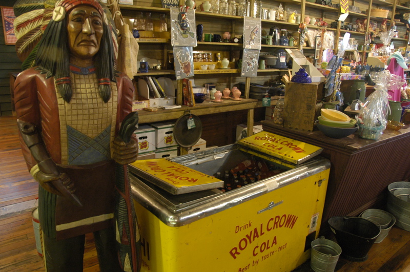
 Ocracoke is basically a lot of National Seashore with a small town at the southern end. The town is a cross between a charming historical village and a modern tourist trap. You can see the ongoing struggle between the two. It seems like the factions have each established their own strongholds: modern tourism along the harbor, and historical treats hidden on interior streets paved with oyster shells.

There are a few interesting things to see in town: a couple of historical cemeteries, the lighthouse, the harborfront. (You’ll see that despite my earlier complaints about photographing lighthouses, I couldn’t resist trying again today.) To really get involved you will want to talk to people and hear the stories. It’s all about the little things here. There’s no “high concept” entertainment. I would have liked an interpreted walking tour of town, but we got here so late because of the ferry delay that we didn’t have time. We settled for walking the town on our own, and three ice cream treats afterward.
If you care to keep your RV in the center of Ocracoke, within a short walk or bike ride of everything, you can stay where Bert & Janie stayed. There’s a small RV park called Teeter’s just off the main street, next to a historical cemetery and across the street from a candy stand. The park is just a grassy area crowded with RVs, but you’d go there to have the convenience of being right in town.
We have extended our stay in Frisco for another two nights. The cold showers are actually pretty refreshing after a day of sticky hiking, and I can’t think of any place to go to which would have a nicer view than this campground. Our water is holding out fine and our batteries are 98% full every afternoon. Friday we expect rain but that’s OK. I’m planning a work day and we’ll still get out for a little while anyway.
May 14, 2008 at 9:38 pm · Filed under Places to go

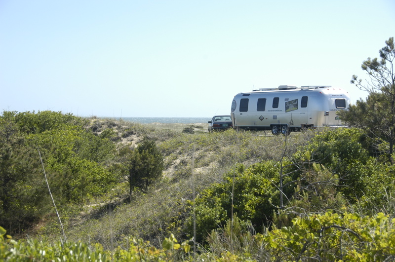
We made the right choice in coming to one of the National Seashore campgrounds. We are at Frisco, one of four campgrounds maintained by the National Park Service. The sites are well spaced and separated by dunes and natural vegetation. The views from the upper sites are magnificent, and the lower sites are just a short boardwalk from the beach. There is endless open beach to walk on, collect shells, surf, and even drive if you have 4WD.
Of course, this all comes at a price, and I don’t mean dollars. The “price” is some slight inconvenience. There are no hookups, and no dump station. This means we have to be very careful with our water usage if we want to stay a while. We have not had access to a dump station or electricity since we left Santee State Park three nights ago.
So we are using the campground showers, which feature only cold water. I tried them today and found that pulling the shower rope over my head resulted in a powerful inundation. It’s refreshing to say the least. Looking on the bright side, it gets the job done, and the cold water motivates you not to waste any.
The key to survival is to time the shower for the hottest part of the day. Since it’s currently not exceeding mid-70s here at any time of day, that means a limited window of cleansing opportunity. But this sort of inconvenience has kept the crowds away from our campground. They are at the many RV resorts in the area, where they can get full hookups, a game room, mini golf, a pool, laundry, etc. While those things are useful when you need them, we came here prepared to go without, specifically so we can stay here.
Electricity is no problem this time of year. The sites at Frisco have no overhanging shade trees, the days are long, and we don’t need the power-hungry furnace at night. Our two solar panels are producing much more power than we need. This morning we were fully re-charged before noon. Of course, if some weather moves in we would have much lower power generation, but we have enough battery capacity to ride out a couple of cloudy days.
Anyone who wanted to stay here in an RV could do as well as us even without a gray water holding tank or solar panels. A simple “blue boy” external wastewater holding tank, and a quiet Yamaha generator would do the trick.
 The first stop of our travels today was the iconic Hatteras Lighthouse. Everyone takes the same picture of the thing, and most of them are awful. It’s hard to photograph a really tall object (lighthouse, redwood tree, skyscraper) and end up with a photo that makes visual sense and looks interesting. I played around with it a little, but there wasn’t much satisfaction in it. I’d rather shoot photos that are more evocative, and a big stack of painted bricks just doesn’t do it for me.

We were surprised to find that the National Seashore has a Junior Ranger program, which of course Emma had to do. It’s a pretty easy one, so she snagged her badge before lunchtime.
Everything is expensive on the islands, especially fuel. Now I regret passing up those gas stations in mainland North Carolina selling unleaded at $3.69. Here it is running as high as $4.07. But I was particularly offended by the local campground that refilled my 30# propane tank last night and presented me with a bill for a whopping $43.20! That’s six bucks a gallon, plus tax. When I commented on the outrageous price, I was told, “Gas is expensive. Everything costs.” For comparison, the current price in Richmond VA is $4.50 per gallon.
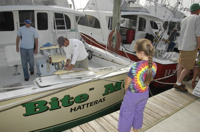
One of the activities on the island is to go to Hatteras Harbor when the fishing charters come back, around 4:00-5:00 pm, and see the catch. It’s a small show, watching the proud fishermen posing with their yellow fin tuna, king mackeral, wahoo and dolphin (not the porpoise type, but a fish). The fish sometimes cleaned right on the boat, and others are cleaned & frozen at a nearby hut.
I took a lot of photos today from all over Cape Hatteras, more than I can fit into the blog, so there’s a new Flickr photoset online if you want to peruse that.
 Our final activity of the day was to hit the beach. Yesterday it was too windy, but today things are much calmer. Two boardwalks stretch from campground to beach, so access is easy. The surf is still much too high for swimming, but there’s some shelling, some birding, and lots of space to just walk and breathe in the salty air. If you look closely, there are a lot of little things to occupy one’s attention.
We bought two nights at Frisco when we arrived, but clearly we are going to need more time to explore the area. Other than the water limitations, we have no reason to leave. There aren’t any mosquitoes at all, I’m able to work conveniently from the Airstream, and we are in a nice spot at a cheap price. Tomorrow morning I’ll pay for a couple of more nights, and then we may move up the coast.
May 13, 2008 at 4:46 pm · Filed under Roadtrips
We set the alarm for 6 a.m. so we’d be ready to get on the 7:00 a.m. ferry if it were running. I was thinking this was a waste of a perfectly good opportunity to sleep in, since the forecast was for continued strong winds all day, but for whatever reason we did it anyway.
At 6 a.m. the alarm rang, and I gave serious consideration to the idea of getting up, but decided the bed was too warm and the trailer was too cold. (It dropped into the mid-50s last night and we have not been using the furnace.) Eleanor got up and dressed, apparently feeling industrious, and she went out to the toll booth to have a talk with the ticket-seller.
 The 7 a.m. ferry did leave, but we stayed to consider our options. I didn’t want a wild ride on the waves even if the ferry captain was willing to go. The waves looked every bit as menacing as they did the day before, and the wind was scarcely less. Officially, the forecast was for 20-25 knot winds and seas 2-3 feet, but that seemed optimistic. The ferry is scheduled to take 2.25 hours, which is a long time to be holding onto one’s stomach.
Finally we decided to take a chance and go, so we shoehorned the Airstream onto the ferry. That was an interesting process in itself, since I don’t have much faith in strangers who want to guide me forward or backward. I was busily watching in all directions as we crept on board and into the narrow lane, but the crew didn’t want me to watch the side mirror. They wanted me to look only at them and trust them to get me past protruding corners and curbs.
 Not a chance. I had already read the ticket they gave me which says very clearly: NOT RESPONSIBLE FOR VEHICLE DAMAGE ON BOARD. The guy waving to me to come forward and go more to the right wasn’t going to pay to have my aluminum fixed if it turned out he had miscalculated, so I double-checked in the side mirror. He got annoyed that I wasn’t solely focused on him and came over to fold my side-view mirror in! The mirror was nowhere near any object it might hit, so I’m pretty sure this was done to prevent me from using it. Now I was annoyed, and I went even more slowly to compensate for the loss of a perfectly useful safety device.
When it was over, the Airstream was parked so close to the curb that the sidewalls rubbed on the way out (bad for the tires), and we could open the entry door only about a foot. But it was enough to squeeze in, which was all we wanted.
Having an RV on an ferry like this is definitely the way to go. Bigger ocean-going ferries tend to lock the vehicles below deck and you can’t get to them, but in this case we had access to the Airstream, which is like having a first-class cabin on a cruise. For two hours we had all the comforts, privacy, and more space than anyone else. Outside it was far too windy to be enjoyable, and on the upper deck there were hordes of high-school aged children, who had been released from two tour buses to ransack the ship. Every car owner was subject to sporadic sneak attacks from kids chasing each other around and being generally as obnoxious as high schoolers are capable of being, but inside the Airstream we were completely at home, enjoying a quiet view of the turbulent sea going by.
 Apparently the Bonine worked because I felt fine for the entire ride, and it was very wavy. Seas were running 4-5 feet with occasionally larger swells. We’d know we hit one of those when the ferry made a huge BANG sound. The high schoolers stood up in front and screamed whenever they got drenched by the spray.
Our criteria for a campground on the Outer Banks was simple: someplace with good cellular service (so that you dear blog readers would not be deprived, and so I can get some work done), chosen from the four primitive National Seashore campgrounds. I wanted the Cape Hatteras National Seashore campgrounds because they had a reputation for beauty (well deserved, I can now see), and they provided a very affordable alternative to the commercial campgrounds which are currently running up to $80 per night.
Ocracoke Campground, the southernmost of the four National Seashore campgrounds, looks great but there’s not a spec of cell phone signal there, so we passed it by. This meant a second ferry to Hatteras, which is free and takes about 40 minutes. Once again we struck the fierce waves and the winds seemed even stronger than before.
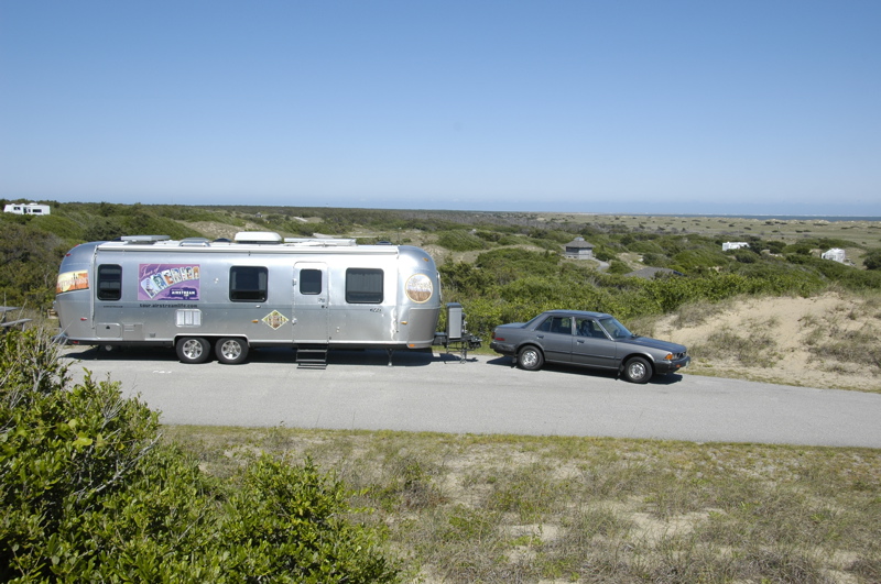
Just a few miles north of the ferry landing we found the second campground, called Frisco, and determined that the cell phone does work in about half the sites. We picked a site in the highest part of the campground (for best possible coverage) and settled in.
We have a magnificent view. It’s one of those ten-million-dollar views that you can get one of two ways: (1) Buy a ten-million-dollar piece of property; (2) Buy an RV and stay at one of many magnificent public lands for $20 per night. We chose Option 2.
It is a short walk to the National Seashore from here, but today the beach is uninhabitable due to the high winds. The fine sand will pelt you mercilessly and flay the flesh from your skeleton. We had this experience yesterday at the ferry dock, although we still have some flesh left.
Tomorrow is forecast to be much nicer: warmer and with only 10-15 knot winds. This is after all near where the Wright brothers chose to work on heavier-than-air flying machines because of the constant breeze. It seems the wind never really stops, and the mosquitoes have learned to make aircraft carrier landings as a result. Fortunately we have not yet seen any mosquitoes and I hope that this is their week for vacation.
Our coordinates: 35 °14’11.17″N 75 °36’27.01″W
May 12, 2008 at 2:19 pm · Filed under Roadtrips
Cedar Island NC is just 50 miles from where we narrowly avoided tornadoes last night. We crossed lots of little bridges from one shallow island to another, and eleven miles of salt marsh, to arrive at the Cedar Island ferry dock.
 The low pressure system that brought us the thunderstorms last night is exiting with a parting gift: gale-force winds that have whipped the normally placid Pamlico Sound into a tempest. Since the ferry to Ocracoke has to cross 22 miles of this water, we knew that our 2 pm reservation was in serious jeopardy, but we figured we’d come out anyway and see.
 It was even windier than I expected. Just waiting in the line, the Airstream is rocking in the wind, and the wind is getting worse. Officially the ferry cancels if the winds in the Sound exceed 45 knots, and so far they have canceled the noon, 2 pm, and 5 pm ferries. I bought Bonine (seasickness medicine) at Wal-Mart last night, preparing to “tough it out” if the ferry was running, but I won’t get a chance to try it today.
When we arrived there were about half a dozen vehicles parked in the standby area, all with very glum-looking people sitting in them. It turns out they had good reason to look that way. The nearest alternative ferry to the Outer Banks is about six hours’ drive from here. They had the difficult choice of waiting 2-3 more hours to see if the next ferry would be canceled, or starting a very long drive and arriving at midnight, if at all.
On the other hand, we are in fine shape. We have no reservations on the island (a case of our “no reservations” policy working for us), and we are in our Airstream with all the comforts of home. In fact, we are home. So we dropped the tongue jack and the four stabilizers to reduce the rocking, and set to the ordinary tasks of our day, such as making lunch.
We are actually pretty comfortable despite the tremendous winds. We had bought a chocolate cake last night to celebrate Mother’s Day with Eleanor (a Mother’s Day which will live in infamy thanks to that near-miss by a tornado) and since we didn’t get a chance to eat it, we broke it out for a post-lunch treat. My phone works fine, and I’m able to get online and do some work.
We’re also making good use of our solar panels. The sky is studded with cumulus clouds whipping by, and between clouds we are making enough power to fully recharge the trailer’s batteries, and run my laptop as well. Since the campgrounds we are heading to don’t have hookups, we expect to be on solar power for as long as a week, so this is a good start.
Now we have a reservation for the 2 pm ferry on Tuesday, but from the marine weather report it looks unlikely that we will actually go anywhere. We may well be parked here until Wednesday, when the wind is finally forecast to calm. That may seem tedious but it beats driving six hours to try to get another ferry, especially when I’m sitting here eating chocolate cake and surfing the web.
 It seems likely we will be able to stay parked in line overnight, but if someone asks us to move along, there is a campground adjacent. The campground is one of those afterthought parks attached to a motel, with a couple of dozen spots featuring water & electric, six or so with full hookups, and nothing else. You pick a spot and then register at the motel.
 We’d get one, but the handful of full-hookup sites are taken and there’s no dump station. We already have water and electric, and really the only reason we’d go to the campground would be to empty our holding tanks in preparation for more boondocking on the Outer Banks.
This spot reminds me of an article which appears in the Summer 2008 issue of Airstream Life (which is already in the mail to you — I promise!). Tom Palesch wrote a nice piece about what he calls “Big Water Camping,” meaning camping at marinas where ocean-going vessels come to call. It turns out you can do it at a lot of places around the Great Lakes. We’re getting a version of that right now, camping near the ferry dock. There are big boats, a visitor’s center, a post office, a motel with restaurant, and a tremendous view of salty waves frothing just beyond.
So we’ll stay right here and see if we get a lucky break in the weather. In the meantime, we’ve got a free waterview campsite for the day, and there’s plenty of chocolate cake.
Our coordinates: 35 ° 1’1.26″N 76 °18’56.05″W
May 11, 2008 at 9:48 pm · Filed under Maintenance, Mobile technology, Tips & Ideas
We had two near-misses today.
We stopped at the Wal-Mart in Morehead City, NC, because our ferry reservation from Cedar Key to Ocracoke is for 2:00 pm on Monday. Nothing to do for a few hours but hang out, which I was really looking forward to after driving about 280 miles from Santee SC today.
One thing I had wanted to do for a while was install the Doran 360RV tire pressure monitoring system we obtained last week in Florida. Yes, after all those tire failures and flats, we are finally doing something about it. While I can’t stop the nails and screws from puncturing our tires, at least I can know we’ve got one before a tire blows out.
The 360RV consists of four pressure sensors which screw onto the tire stems (with locking collars so they don’t come off), and a monitor for the truck. John Irwin had emailed me a few days ago to say he, too, had gotten a Doran unit, and today he wrote that the installation was “absolutely child’s play.” That was enough to encourage me to open the box and put the sensors on.
The first sensor I installed, on the left rear wheel, immediately caused the monitor to start beeping an alarm. It showed 32 psi in the tire, which is painfully low. I thought, “Darned thing … already giving me bad information,” and then I noticed the tire did look low. So I checked it with my digital gauge. Yep, 32 psi when it should have been at least 60 psi.
So I started my relationship with the Doran 360RV by owing it an apology. It was right to be alarmed about the state of that tire.
“Bob,” a motorhome owner who was parked next to us, lent me his air compressor and a power connection to his generator. (I do have a 12v compressor but it is rather slow.) I pumped all the tires up to exactly 65 psi, and then checked the suspicious one for what I knew had to be there.
And there it was: a screw, deeply embedded in the tread, right on the edge of the sidewall where it can’t be patched. Another $150 tire gone. That’s the fifth tire this year, and it’s only May.
So let me just get this off my chest now. ALL YOU PEOPLE WITH SCREWS: PLEASE KEEP THEM OFF THE ROADS!
This was the first near-miss. I say that because if I hadn’t been installing the Doran 360RV, I probably would not have noticed that tire until later, and it could have shredded on the road. Did I need further evidence that we needed a tire pressure monitor?
A few minutes later, Eleanor came out to say there was a tornado warning for the area. I watched the radar loop on TV and the weatherman was talking about three “hook echoes” in the radar. Hook echoes are the signature of tornados. Tornados make RVs and virtually everything else go flying. Plus, the storms had the potential for 65 MPH winds and nickel-sized hail. I wanted to drive away, but trapped between a line of heavy thunderstorms and the coast, we had no place to go.
So I came to the conclusion that we needed to evacuate the Airstream for the safety of the concrete block Wal-Mart. We packed up the dinner we were about to eat, grabbed our rain jackets, and went inside. I also took the precaution of shutting off the propane at the tanks, in case the worst-case scenario happened.
Now, if I had thought about it some more, I would have taken a couple of other things, too. Our walkie-talkies would have been handy if we were separated. Our cell phones worked but the cell phone tower was right next to the Airstream, so if one went, the other probably would too. I also would have grabbed a flashlight, in case the power went out in the Wal-Mart.
This was our second near-miss. For about 20 minutes, we had just rain and a spectacular lightning show. Eleanor wandered into the store to ask about tires, and then suddenly, “it” hit. The parking lot disappeared in black rain, the windows began to shake, and I heard a rumble like a freight train. I remembered that people often describe the arrival of a tornado sounding like that. I grabbed Emma by the jacket and we went to a spot I’d previously picked out inside the store, where two cinder-block walls formed an L and where there were tables to duck under.
I have to admit that it was terrifying for a minute or two. People were starting to panic, while others were obliviously trying to exit the store into the vortex. We heard several loud bangs, and then the sliding doors in front of the store blew outward. The managers secured the doors and locked them while we hung back in our safe spot wondering if it was time to duck under the table yet.
I was worried about Bob and his wife, parked out there by our Airstream, but in the midst of this, I saw Bob fire up his motorhome and drive over to Lowes. He parked under their pick-up area’s awning, safe from hail and mostly in the lee of the wind.
When it was over, I surveyed the parking lot. A lot of carts got loose and damaged cars, but the worst happened to a different motorhome parked about 300 yards from our Airstream. It was blown over, and slid down a shallow embankment to come to rest in the Lowes parking lot. When I got there the police were already on the scene and the occupants had exited by breaking through the windshield.
I’m pretty sure they got hit by at least a strong downburst, if not a bit of tornadic activity. The motorhome was facing into the prevailing wind, whereas the Airstream got it directly broadside. The Airstream survived just fine (as far as I can tell in the dark), but the motorhome took it hard. Was it the aerodynamic advantage of the Airstream, or just luck?
Tomorrow we will recover from all of this. I’ll go shopping for a tire and install it on the trailer, and inspect the Airstream for damage on the windward side. With luck it will be a bright sunny day and this little nightmare will be behind us. But two near-misses in one day … it makes me think.
May 11, 2008 at 12:33 pm · Filed under Places to go
I’m finally getting to post at a grocery stop near Lumberton NC … there was no cell service in the state park campground. They did have wifi at the Visitor’s Center but I was too wiped out yesterday to make use of it.
Is it the humidity? I’m not sure, but after our day at Congaree National Park (about 35 miles north), we were all collapsing. We only hiked 2.4 miles on the boardwalks, so I can’t claim it was the exercise.
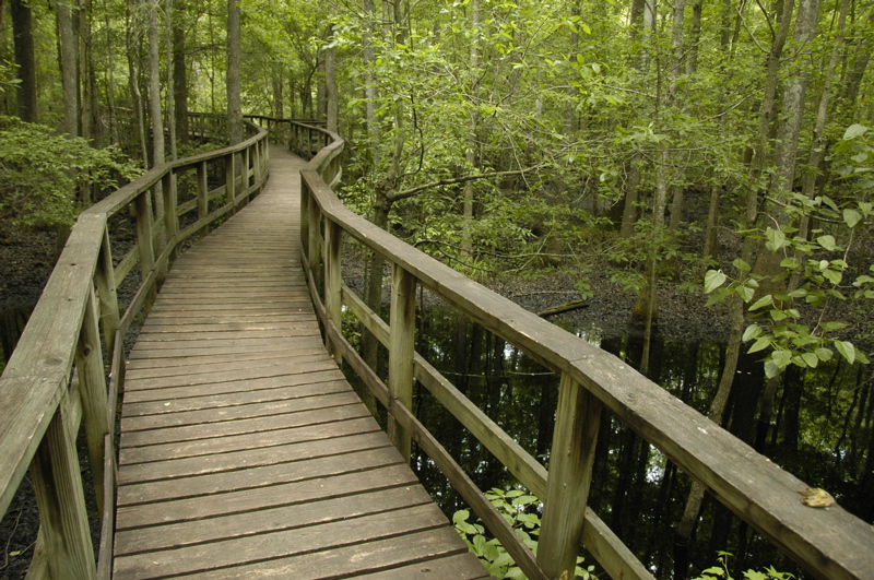
Congaree is a really “different” type of national park. At first glance, it’s a swamp. But there’s a lot more to it than that. It’s really a forest that floods about 10 times a year, and that regular flooding inspires an amazing diversity of creatures and plants. The trees are very tall — a fact of which the Visitor Center displays, brochures, and movie all tout extensively — and it has a canopy like a rain forest, so it’s dim and humid down below.
 In our little 2.4 mile walk we managed to spot three different types of skink, some very pretty damsel flies, a barred owl (photo below), a snake we haven’t yet identified, and lots of other insects. Especially mosquitoes. This is the only national park we’ve ever seen with an official “mosquito meter.” Fortunately, the buggers were only “mild” by my estimation, and we brought deet along. I wouldn’t want to be here when the meter reads 5 or 6.

There are a lot of other trails in the park, and in the right kind of weather I could see hiking all of them. You are free to go off-trail in this park as well, but the rangers advise bringing a compass since it is easy to get lost among the tall trees and featureless mud. For our part, doing the Junior Ranger program (badge #33) and stopping many, many times to examine bugs and such kept us in the park for about four hours.
This morning thunderstorms invaded South Carolina, and we were awoken at 5 a.m. by the sounds of heavy raindrops pounding on the aluminum roof and the plastic vent domes. It’s like having a gang of monkeys on tympani up in the trees, a noise designed to wake you up.
It’s a sound we haven’t heard in a long time. As I lay in bed thinking about it, I could see how drastically this changed my plan for the day. We were going to cover 300 miles today and position ourselves for an early-morning ferry ride to Ocracoke NC on Monday morning. At this writing we are in the clear, between rain bands, but expecting more tonight and tomorrow thanks to a giant low centered over Indiana.
With rain, everything slows down. Disconnecting the utilities in the rain, visiting the dump station in the rain, towing on I-95 in the rain ““ all of these things take more time. We will have to set our goals a little lower, and possibly get up earlier on Monday to make up for it if we have to pause later today.
May 9, 2008 at 11:59 pm · Filed under Places to go, Roadtrips
We passed a warm and humid night, parked in the back of Cracker Barrel, with all three Fantastic Vents running to circulate some air. Thank goodness for those fans. On nights like that, they are the best upgrade we ever installed. We’ve even survived boondocking on 100-degree nights in Death Valley with them.
Our plan shaped up enough for us to know where we were going today. We towed just 118 miles up to Santee, SC, and the Santee State Park on Lake Marion. It’s a large shady park with two campgrounds in mixed deciduous forest, and it would be a fine overnight stop for anyone coming up I-95, but our real goal was to have a place within a reasonable commuting distance of Congaree National Park ““ with 30-amp electrical hookups for the air conditioning.
 The major theme of Santee State Park seems to be boating on the lake. The lake features a flooded cypress “forest,” which is an unusual feature. Since we didn’t happen to strap a boat to the roof of the Honda, we walked the ¾ mile nature trail instead.
Frankly, there wasn’t a lot of interesting nature revealing itself on the trail, except insects such as spiders, beetles and ticks. Emma discovered a few ticks on her shoes from a short sojourn off the trail into some grass, but fortunately I’d sprayed her legs with bug repellent before the hike and we were able to evict the ticks before they got a nibble of her.
 For most of the hike I was elected to walk in front so my face would collect the webs strung across the path, and I eventually amassed quite a collection of them. Finally I started keeping my eyes open for spider webs, and that led to my involvement in trying to photograph spiders in their webs. It’s a worthy photographic challenge, one which will probably keep me occupied for a while just like hummingbirds and bees have occupied me at various times. Right off the bat I can see I don’t have the right lens for the job “¦
Even in the shade of the trees, the humidity slowed me down. Just that little walk made me look forward to some air conditioning. We have not yet escaped the southeast humidity, and it’s likely we’ll find more of the same up north in a few weeks. I’m going to have a tough readjustment to northeast summer conditions.
 South Carolina can be such a polite place. I haven’t heard Eleanor referred to as “ma’am” more than once or twice a year, but here she has gotten that treatment half a dozen times this evening.
The peak of “sir” and “ma’am” occurred when we stopped at the Lone Star Barbecue & Mercantile for the nightly dinner buffet. This place is built out of four buildings recycled from the former community of Lone Star: O.K. Zeagler’s General Store, the post office, Dantzler’s Social Hall, and Schuler’s General Store. Now connected together along State Park Road, they make a popular restaurant. On Saturday nights the line can go “all the way out to the oak tree,” we were told.
Maybe I was just hungry, but I can recommend the Lone Star for a taste of local food. It’s nothing fancy, just good southern cooking. Between the three of us, we had fried chicken, green beans, “tomato pie,” mashed potatoes, “hash” (a semi-sweet puree of beef, I think) over rice, macaroni & cheese, banana pudding, and Indian pudding with butterscotch topping for dessert. $9.99 for adults and we sure didn’t leave hungry. Being just a couple of miles off I-95, this place is a great lunch or dinner stop for anyone passing by.
Fuel report: towing at 60 MPH on the flatness of I-95 through Georgia and South Carolina, with the A/C on and only mild crosswinds, the Armada got 11.0 miles per gallon. That’s about the best it has ever done, and fairly good for a gas engine pulling an 8000 lb trailer.
By comparison, towing at 72 MPH in west Texas, in similar conditions, the Armada got between 8.6 and 8.9 MPG. That means going 60 saved us about 20% on our fuel bill. I’m going to work a 60 MPH speed limit into all my long-distance travel plans going forward.
« Previous entries ·
Next entries »
 Ocracoke is basically a lot of National Seashore with a small town at the southern end. The town is a cross between a charming historical village and a modern tourist trap. You can see the ongoing struggle between the two. It seems like the factions have each established their own strongholds: modern tourism along the harbor, and historical treats hidden on interior streets paved with oyster shells.


