Archive for September, 2008
September 13, 2008 at 5:21 pm · Filed under Where's George?
Back in mid-August, following a $1500 round of repairs at Airstream, a faithful blog critic who goes by the alias of “Dr. C” suggested that we “pass the digital hat” for donations. This was intended to help us with the financial cost of traveling around and tantalizing you with blog entries about all the fun we are having.
Dr. C’s comment was well-intended but I was pretty sure we wouldn’t be inundated with money, so I responded by saying that we already get a lot of non-financial support from blog readers, and that was good enough. I further said that if anyone felt blog readers could do more, they should write their suggestions on the back of a $20 bill and mail it to me.
 Well, somebody actually did that, and so I got the $20 bill pictured at left when we picked up our mail in Kanab yesterday. The letter came anonymously, with a postmark of Troutdale (Oregon? Virginia?) over a “Princess Aurora” postage stamp. At least, I think it was Troutdale — the cancellation was not clear.
Despite my severe disappointment that the sender ran out of fifties, I appreciate the thought and want to put the bill to good use. I have registered it at Where’s George.com, a website that — believe it or not — tracks the progress of US currency as it is spent.
The system depends on people voluntarily going to the website and entering information about the bill, when they get it. To alert people to the trivial importance of doing so, along the top edge of the back of the bill I have written “Please track me! at wheresgeorge.com”.
Let’s see if anyone actually does. You can follow the progress of the bill by following this link. If there are updates posted online, I’ll get an email too, and I’ll mention it on the blog.
Of course, to get the bill started in circulation, I need to spend it. It’s my responsibility and I intend to rise to the occasion soon. I think we may try one of Kanab’s little restaurants on Sunday. Hopefully the bill will begin its own Tour of America soon and not end up stuffed into a mattress somewhere, and we’ll be able to see where this thoughtful donation goes from here.
September 12, 2008 at 5:21 pm · Filed under Tips & Ideas
We’ve moved on from Bryce Canyon to Kanab UT for a few days. It’s time to resupply the ship and do some serious work.
Our last hike in Bryce yesterday was terrific, and I’ll have photos uploaded to Flickr soon. But there’s no getting away from the fact that the park is crowded. We rarely had solitude, which we’ve come to expect often in other national parks. We would have had to hike many miles from the rim to get the sort of peace that is available in abundance at less popular parks.
Looking at the park service’s report on 2007 visitation yesterday, I was curious to see some of the least-visited parks that we’ve been to. Given that we like quieter places, I was wondering which ones we’ve missed.
Turns out we’ve missed a lot of them. Of 360 parks in the report, the least-visited one we’ve been to is Fossil Butte National Monument (Wyoming), ranked #314 overall with 19,853 visitors. I remember that visit well. Emma got a lot of attention from the rangers, and only a handful of people walked into the visitor center while we were there. It was also memorable for the broken lug stud later that day.
Hovenweep NMON in Utah ranks #305 in the list. We loved that place for its solitude, the unique Ancient Puebloan ruins, and the beautiful campground.
Before we started full-timing, we visited St-Gaudens National Historic Site in New Hampshire (#303), and I remember parking our 1968 Airstream Caravel on the grounds (there’s no camping) for the afternoon. It’s a nice site, attributed to a famous artist, but slightly obscure.
Vermont’s only national park is Marsh-Billings-Rockefeller National Historic Park. Until a few years ago, we didn’t even have that one, and the only slim presence of the park service was the Appalachian Trail. We’ve visited it several times. It’s ranked #296.
Ft. Laramie NHS (Wyoming) is #286. This is a great piece of western expansion history and worth the small detour to visit. If you’re already wandering through Wyoming you’re off the beaten path, so why not explore a few miles further?
Gila Cliff Dwellings NMON (New Mexico) is #284. We visited it when Eleanor was very pregnant with Emma, in early 2000, making it Emma’s first national park. The ranger who guided us was extremely concerned about Eleanor’s condition, since she was in that point of the pregnancy where she looked somewhat like a kangaroo. But we were the only people on the trail that morning and so we got a very personal guided tour, up and down the ladders of a cliff dwelling.
We’ll be making a point of seeking out some of the less-visited sites in the future. Tomorrow we are planning to spend part of the day at Pipe Spring NMON (#277), only about 35 miles from Kanab. When we get back to Tucson, we’ll finally make a trip to nearby Tumacacori NMON (#280), too.
Looking through the list, I see “the ones that got away,” and now I’m sorry we passed them by. When we went up to Scotts Bluff (Nebraska, #214) we made a decision to skip Agate Fossil Beds (#332) because it was hard to get to and there weren’t any facilities. In all the years we lived in the Boston area, we never once visited Saugus Iron Works NHS (#348). Last fall when we were in Montana we skipped Grant-Kohrs Ranch NHS (#321), which was a shame. Bert Gildart even mentioned it in an article in Airstream Life a couple of issues ago.
Well, you can’t see them all, although some people are trying. In Great Sand Dunes we met a guy who was up over 200 parks so far. He’d been at it for decades. He even bagged some very remote and hard-to-reach parks, such as the National Park of American Samoa, Dry Tortugas NP (Florida), the Virgin Islands parks, most of the Hawaiian parks, and all of the Alaskan parks. He was seriously dedicated to the task, even to the point of tracking new national parks that have been proposed so he can plan visits.
 Collecting the National Parks Passport stamps at every park has been something we’ve been doing since 1997. It’s a great way to keep momentos of your travels in a cheap and portable format. The ink stamps are free, and since there are hundreds of them, you can collect for a long long time. Some people feel rather passionate about it and go to extraordinary efforts to hit as many parks as they can. We’re taking a more measured approach, just visiting the parks as we see the opportunities. Still, with all this time traveling, we’ve accumulated 110 stamps so far.
More surprising to me is that we have absolutely no stamps from the “National Capitol Region”, which includes Washington DC. That’s the easiest place in the world to collect stamps because of all the national park sites clustered in the District. We’ve been there many times, but for some reason I always forget to get the dozen or so stamps that can be found there.
After my photo collection, the battered blue Passport book is my most prized souvenir. I recommend that anyone who likes visiting national parks buy this inexpensive book and start collecting the stamps too. Each one reminds me of a great time in a great place, and without this book I would probably forget the dates of our visits. Big or small, every national park has been a place we’d like to remember.
September 11, 2008 at 11:19 am · Filed under Places to go
When met Rick on the road at Escalante a couple of days ago, he told us he was coming out of Bryce Canyon and heading for Capitol Reef. We exchanged tips about the respective parks, but his warnings about Bryce were not very encouraging. It was crowded, he said, and solitude on the trails was going to be hard to find.
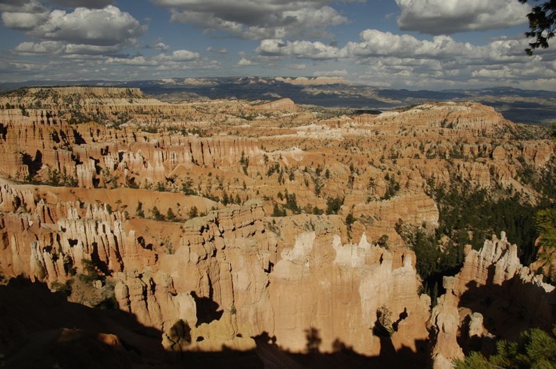
 He wasn’t exaggerating. For whatever reason, Bryce has been chosen by far more people that the other Utah parks we’ve visited, in fact, one million visitors per year. Now, Bryce is a very nice park, but I can’t quite see that it is twice as good as Capitol Reef or Mesa Verde (each of which get about half a million visitors per year), or three times as good as Big Bend. I suspect the volume of visitors has to do with the fact that it is close to Grand Canyon and Zion, and because you can see the best views from your car without any hiking effort.
The tour buses are here in vast fleets, segregated by foreign country. Standing at the overlooks I could tell which bus had arrived by a sudden wave of people speaking a different language. There were Japanese, Italian, German, and Scandinavian waves, and as tour groups tend to do, they would all go to the same place at the same time. This caused logjams here and there, but Bryce has been engineered to handle the crowds, like Disneyland. There are bus depots at the major stops, special bus parking areas, and traffic patterns. A shuttle service operates in the park and reduces individual car traffic & parking problem, too. Still, I wonder if in a few years cars may be prohibited from parts of the park as is currently done in Zion.
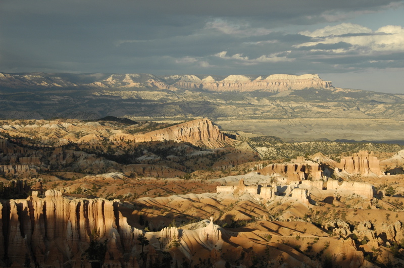
In Zion, you are in the bottom of the canyon looking (and hiking) up. In Bryce, you are on a narrow ridge that defines one edge of a valley, and all the hikes go down. It’s more like Grand Canyon in that respect, but the valley (they call it a canyon) is not as well defined on the opposite side. The best viewing is in sunny conditions, especially as the sun is rising or setting.
 One popular ranger-led activity is pictured at right. Care to guess what it is?
Tree-sniffing! The bark of the Ponderosa Pines sometimes has a distinct odor like butterscotch, if you’re willing to press your nose to one and take a big sniff. Being able to watch this is one of the upsides of having crowds in the park.
Part of the reason the park is still so busy is that the season is very short. The park had its last snow in mid-June, and temperatures began to go below freezing at night in mid-August. Days are warm right now, but storms are frequent and the lightning is really dangerous. People stand out on the exposed ridges and get zapped at the rate of about one person every other year. We got chased off Rainbow Point by an approaching line of showers and high winds while we were observing a 1,600 year-old Bristlecone Pine tree. With the constantly-changing weather (and a bit of laziness), we were only able to hike about three miles all day.
 After two nights, we are being forced out by an incoming tour. The campground we are staying in can’t accommodate us any longer, and the national park campgrounds are still very full. Weighing the options, we’ve decided to leave Bryce Canyon and head south to Kanab for a few days. We are booked into the North Rim of the Grand Canyon starting on Wednesday, so we have a few days to get ahead on work, and make some side trips. But since it is only about 80 miles to Kanab, we will take advantage of Bryce’s shuttle system to have one last hike. We’ll park the Airstream in the large shuttle parking lot, hike the Queen’s Garden/Mojave trail (2.9 miles), and then proceed south to Kanab.
 Also, we have confirmed that we will be going to the Albuquerque Balloon Festival Oct 3-6. This is a major detour east, but it will allow us to visit several other national park sites and explore some of so-called “Indian Country” (mostly the Navajo reservation but also passing by the Hopi, Zuni and several other tribal territories). See approximate trip plan at right — click to enlarge. We’ll go past Monument Valley, spend a few nights in Gallup, drop by some national monuments in New Mexico, and then go check out a few sights in southern New Mexico before heading to Tucson. At this rate, we’ll be back to winter home base in mid-October, just in time for the nice weather down there.
September 10, 2008 at 7:28 am · Filed under Travel / lifestyle musings
Bryce is at over 8000 ft elevation, something to keep in mind if you visit here. It may not seem like a large difference from the other parts of the Colorado Plateau, but it has made an enormous difference since we got here. In Capitol Reef every day was in the mid-80s, and nights were so comfortable that we slept with the roof vents open. But that was at 5400 ft, and a cold front has moved in as well. This morning at Bryce Canyon I woke up before dawn to find the outside temperature at 30 degrees, and the furnace cycling on and off every 10-15 minutes.
The furnace is kind of noisy when it runs, and it gets annoying when it is cycling a lot. It also is a greedy consumer of propane, so I got out of bed and fired up the catalytic heater to see how it would fare with the cold. The catalytic is virtually silent and 100% efficient, so it uses less fuel. We’ve run it a few times this year, but never in such chilly temperatures. Since it has a maximum output of 9000 btus (compared to 30,000 btus for the furnace), I was interested to see how it would do.
Well, the results are in: at full bore, with 30 degrees outside, the catalytic heater is just enough to keep the trailer at about 60 degrees. The middle of the trailer gets warmer than the ends, since the heat has to passively convect through the trailer on air currents, but it’s not bad at all.
Being up this early, and having silenced the furnace, I have been able to listen for sounds from outside. No coyotes howling here, or bugling elk, or even chirping crickets. Instead, I’m surprised at the amount of car traffic I can hear heading into the park at 6:30. People must be starting early for all-day hikes into the canyon.
At 6 a.m. I was treated to a classic “stupid camper trick.” Someone two sites away fired up their generator. After about a minute of running rather loudly, it shut off, and I presumed that they realized their mistake. There’s no need to run a generator in a full-hookup campground with 30-amp power at every site. But no, the motorhome user tried again a couple of minutes later. After three tries to get the generator started, it fired up again and ran for several minutes more in the pre-dawn darkness. This is the sort of thing that ensures your neighbors will not be friendly in the morning.
I can’t imagine any legitimate reason for running the generator under these conditions. My guess is that when I see the motorhome later this morning it will be bearing the giant labels of a rental. They are everywhere right now: big white box Class C motorhomes emblazoned with “ROADBEARRV” or “Cruise America” or “Moturis” or “El Monte RV”. Inevitably, this time of year, they are being driven by European tourists who have come over to take advantage of the weak US dollar, the lack of crowds in the school season, and the endless beauty of America’s western national parks.
They also love the fact that our fuel is only $4 a gallon, compared to the $10 they are used to paying back home, and who wouldn’t love the fall weather? I’m glad people in other countries recognize that the American southwest is one of the most incredible places in the world. They seem to really appreciate being here.
Most of these folks are British or German, but I heard more foreign languages while at Capitol Reef than I think I’d hear in an afternoon at the United Nations. They seem to have some experience with driving motorhomes so they aren’t always terrifying, but I still always watch carefully when one comes down the road. I think they should paint the rental RVs yellow or orange, like rental trucks, so that people can immediately know that there’s quite possibly a clueless newbie driving that huge box.
The sun is still below the horizon but there’s some light in the sky now, and I can see the motorhome in question from my window. Yep, it says “Cruise America” all over it. From his dress, the occupant appears to be American. He has clothes hanging from the radio antenna, and at 7 a.m. he is taking down a clothesline strung from the passenger’s rear-view mirror to a tree on our site. He is hustling to get packed up, like a tornado is coming. Doors are banging open and shut every minute or so, and various thumps are emanating from the interior. When outside, he is storming back and forth and shaking his hands from the cold. Maybe he’s in danger of paying for another day, and wants to get back to the rental office soon.
I would hate to count the number of breaches of RV etiquette that I see and hear being committed next door. Fortunately, I was already awake, and I’m not a stickler for etiquette anyway. Mostly it’s an amusing show that reminds me of when we got our first Airstream and had to learn the ropes.
I’d hate to learn on a rental RV. One of the first things I noticed about having a travel trailer is that everything is highly personalized. There’s no single “right way” to do everything. You have to work out your own systems, your own storage methods, your own checklists, and get to know your equipment. You can’t do that with a rental because you can’t personalize it. With our own trailer, when I spotted a problem, I could modify things to work better. It’s like having your own apartment versus living in a motel. It’s fine for a short time, but over the long run you want your own stuff.
At this point we have our trailer so thoroughly tweaked and tricked out that it’s hard to imagine being in another. Everything is the way we need it to be, which is probably why we feel so comfortable in it. The catalytic heater is just the latest example. I like the fact that we have our home equipped “just so.”
The Cruise America motorhome has now departed, after several minutes of idling in the campsite and much revving of the engine. We won’t miss him. Things are quiet again. Eleanor is up with the sun, making coffee in the kitchen, and I think this cold morning calls for hot cereal and tea for me. We’ll have a few minutes of time to ourselves before Emma wakes up, and then start planning a day out in Bryce Canyon.
September 9, 2008 at 10:52 pm · Filed under Roadtrips
 Our goal today was to drive 118 miles from Capitol Reef to Bryce Canyon, via Utah’s semi-famous Route 12. This route goes through parts of the Dixie National Forest and the northern edge of Grand Staircase-Escalante National Monument (BLM). We’d been told it was an eye-popping drive, but unfortunately the weather was uncooperative and a lot of the views from 9000 feet and above were obscured by passing rainshowers and fog.
Coming down past Boulder, the view improved. We had considered stopping at the Calf Creek BLM campground, but passed it by with a note to perhaps visit it on another trip. It’s located down in an absolutely beautiful canyon, not far from the spot we were overlooking in the photo at left.
I must be getting used to driving out here on the Colorado Plateau. We rolled up and down grades ranging from 8% to (briefly) 14%, climbed above 9000 feet on curvy roads with no guardrails, in and out of rainshowers, and my reaction to most of it was “ho hum…” Not that it wasn’t beautiful, but the adrenaline rush that usually accompanies towing under such conditions was distinctly muted. Mostly I toodled along, one hand on the wheel, one hand on the transmission stick, thinking about when we should stop for lunch.
Which eventually we did, at the visitor center in Escalante. While we were parked there, we ran into Rick, another Airstream full-timer traveler who has been out on the road for about three months so far. He’s got a sweet 1976 Airstream 30 footer that he refurbished and customized. We hung out for a couple of hours, swapping travel notes, and may meet up again later this winter. Rick’s blog is a bit out of date but he’s planning to get caught up on his latest travels.
With all the puttering, we didn’t get to Bryce until about 5 p.m. The national park’s campgrounds were mostly full, and the few remaining spaces were either too short or very unlevel. The entire North campground seems to have been built on a hill. Also, the site were entirely shaded, which would give us no useful solar power. We decided to go upscale and pay for Ruby’s campground just outside the park entrance.
This is a big luxury for us. We’ve been camping without hookups of any type for a week, which has allowed us to stay close to the parks we’ve been visiting. Upgrading to a commercial campground is like splurging on a five-star hotel. We’re getting full hookups, wifi, a laundry, two swimming pools, two restaurants, and my phone works too. We’ll catch up on laundry, work, email, phone messages — all those annoyances of “real life” –and work in a few hikes in Bryce too.
September 8, 2008 at 3:14 pm · Filed under Places to avoid, Places to go, Travel / lifestyle musings
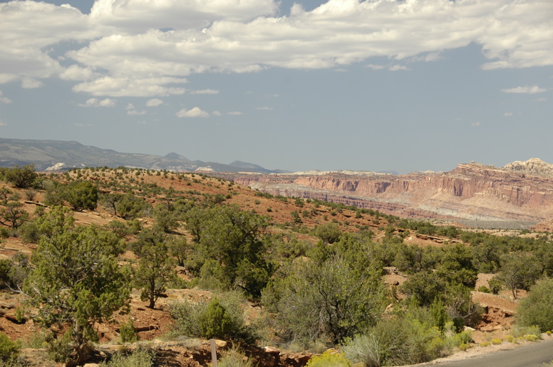
In my rush to post a quick blog entry yesterday I didn’t have time to describe the setting of Capitol Reef. The park is 100-mile long north-south sliver of Utah, surrounding an ancient fold in the Earth’s crust where tectonic plates collided, forced a ridge to the surface, and then weathered into remarkable canyons.
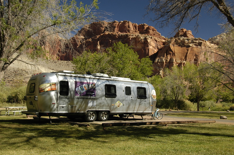
They call this the “Waterpocket Fold” because the geography traps pockets of water which encourage plants and animals in this part of the Utah desert. Indeed, in the center of the Waterpocket Fold are the remains of the historic town of Fruita, where Mormon settlers lived from the 19th century until 1969 and raised fruit trees. The park is centered in Fruita, and the National Park Service still operates the orchards for visitors to pick fruit seasonally.
Fruita is really a series of strips of lush cultivated land inside the canyons, flattened out and manicured into parklike settings. After driving through a hundred miles of red rock desert, it is startling to arrive in Fruita, where green grass and shade trees are everywhere, and a creek flows rapidly alongside the campground. It is like arriving at a city park, an oasis in the midst of dry sandstone and crystal clear blue skies.
The skies are part of the reason the night stars and daytime views have been so startling. The average summer day visibility here is 145 miles! Very little pollution from southern California, Las Vegas, or southern Arizona arrives here ““ so far ““ and there’s not as much airborne dust, pollen, or humidity as other places. The result is magnificent views day or night. Yesterday we could easily see mountains a hundred miles away, from Panorama Point.
In the campground our view is quite different. We are sitting in a canyon looking up at sheer rock walls on both sides. The sun reaches our solar panels more than two hours after it has lit the high peaks of the canyon walls, and we are in shade about two hours before actual sunset. (Fortunately, we are still getting enough solar power to keep up with our daily usage.) From the bedroom’s front window we get a marvelous view of the glowing red sandstone in the light of the setting sun each evening.
The danger of visiting so many incredible western parks in such a short time is that you can begin to lose appreciation for them. It’s easy to say, “Ah, that’s just another pre-historic petroglyph,” or think, “I already hiked a canyon, so let’s skip that.” On a daily basis we are seeing things and hiking places so wonderful that any one of them would be the highlight of a week’s vacation. Too much of that is like eating too much dessert, and we don’t want to get sick of this only halfway through our planned loop of Utah.
We also are spending a lot of time studying the history of the area (Butch Cassidy, Mormon settlers, the “Fremont people,” early European explorers, geologic history, etc.) I have been reading a book about Utah’s outlaws every day, in addition to guidebooks, maps, and interpretive signs everywhere we go. Emma has been working on Junior Ranger projects continuously for over a week, and she needs a break from that too. Even though we are having fun, we are constantly learning about where we are, and eventually that can be a burden too.
So once again our trip plan is changing. (It will keep doing that.) Rather than rush down to Bryce Canyon today, we are spending another day, and possibly delaying our arrival in Bryce. Everyone is telling us that the Rt 12 route from Torrey to Boulder and Escalante is one of the most stunningly beautiful drives in the country. We were originally planning to cover the 118 miles from here to Bryce Canyon in an afternoon, but now I’m thinking we might take most of the day just to get to Escalante, or spend the night at Calf Creek (BLM) for a night. That will allow plenty of time to stop and take pictures along the way, or visit roadside attractions like historic sites.
For today, our plan is very low-key. I’ve been working on the magazine since 7 a.m., and will probably spend the rest of the morning at that. Eleanor and Emma will go explore some of the historic structures of Fruita, and then around noon we’ll go to Torrey to pick up our mail and send/receive email at Robber’s Roost (a local bookstore/café). We might drive another dirt road down a canyon just to see what’s there, but we won’t do any hikes.
In other words, today is a day “off” from the schedule of hiking and studying. It’s funny how a day of business and errands can be a welcome relief from physical recreation. Emma has announced that on her day off she is planning to spend the entire day in bed reading. I think we’re all looking forward to a day like that.
Late note: We found Robber’s Roost to be a very comfortable cafe (and smallish bookstore), but the free wifi didn’t work. There was a connection error when I tried to join the network with my Mac. We asked permission from the on-duty manager to unplug one of their computers and use the that computer’s Ethernet cable to connect to the network. He said it would be no problem. Later, when I was outside on the phone, the Uber-Manager showed up and bitched Eleanor out for connecting to the Ethernet. “I charge for that, you know!” Turns out she knew the wifi was misconfigured so that only PCs can connect to it (not Macs, for some reason), but rather than fix it she chose to blame the Macs instead. The on-duty manager was embarrassed. I could have fixed their wireless router but didn’t even bother to suggest it. The “high speed Internet” connection turned out to be dial-up, too. Go for the coffee, but don’t bother going for the Internet. Go to the burger shop instead.
Second late note: There are few services near Capitol Reef Nat’l Park. Gas is available in Torrey (11 miles from the visitor center), but not much else. Verizon and Sprint have no service here. (We made a few calls “roaming” on some local network, but I’d be careful about that if you don’t have a roaming plan as Eleanor’s phone does.) There is one ATM that we know of, but it didn’t work. The town shuts down even more in the winter season, which I think means all the art galleries close. Come here with everything you might need.
September 7, 2008 at 5:34 pm · Filed under Uncategorized
(Still in Utah, Karen!)
 I’m a bit rushed in posting this blog entry because I am sitting in Slacker’s Burger Joint (“shakes & ice cream”) in Torrey UT, 11 miles from the campground in Capitol Reef, and my milkshake has already melted. I don’t think they will toss me out on account of that, but still it feels like I should have completed all my online business before the end of the shake.
Because I am in a rush, it is hard to summon the superlatives that can adequately describe what we’ve seen in the past two days. Southern Utah is amazing. It is beautiful. It is filled with endless opportunities for exploration, and best of all it is uncrowded. I feel incredibly lucky to be here right now and although we are going to be in Utah for at least another 10 days, we are already talking about coming back.
When I have more time I will post a Flickr album of some of the sights and let you see what I’m talking about. Just the drive up from Natural Bridges through a narrow section of Canyonlands and up to Capitol Reef, was magnificent.
 As everyone predicted, Capitol Reef is a great park. We took it fairly easy yesterday, attending a 3 p.m. ranger talk about petroglyphs, meeting some new friends (Bob and Donna, great people), checking out the Visitor Center, eating pie from the historic farmhouse, and attending the 8:30 ranger talk at the Amphitheater. The latter item involved old time fiddling music and dancing — by us, the audience — while bats flew overhead eating up all the bugs.
 The rest was good for Emma’s ankle, but we didn’t want to be burned out on hiking when we get to Bryce Canyon in a few day, so today we did just one easy hike down a dry canyon to a section of “narrows” where the red sandstone towered about 300 feet above us. The roundtrip was about 2.5 miles. The rest of the time we’ve been cruising the 9-mile scenic drive, trying some of the dirt side roads down winding canyons, and now checking out Internet in nearby Torrey.
We’ve decided to stay a third night at least in Capitol Reef, so I’ll have to commute into town daily for an Internet fix, but that’s not much of a price to pay. This place deserves to be savored a bit more.
« Previous entries ·
Next entries »


