Archive for Roadtrips
April 19, 2008 at 10:19 pm · Filed under Roadtrips
 The casino on Lake Charles did not get our business for breakfast. As it turned out, not only does I-10 roar overhead the RV parking area, but a very loud train comes by three or four times at night. The deafening noise of this train and its long horn blasts will wake anyone with normal hearing. So I slept until nine and found that Adam and Susan had uncharacteristically arisen very early and had breakfast already. We skipped the call of the buffet and just piled into the Armada to continue our journey.
Since we had only about 200 miles to go and all day to do it, we decided to try an alternate route to the New Orleans area. US 90 drops south and comes to the west bank of the Mississippi River via Houma. This is a road I’d never driven, despite having lived in Louisiana for five years back in the 1980s.
US 90 brought us past a turn-off for Avery Island, which is a spot of land surrounded by a meandering river (hence, “island”), where Tabasco sauce is made. Although it seems to be in the middle of nowhere, it is a fairly popular tourist destination. The Tabasco factory offers a free tour, but it costs $1 to cross the little bridge to enter the “island.” (This money is dedicated to maintaining security and ecological conservation on the island, says the brochure.)
Avery Island is a salt dome, which is basically a very deep salt deposit underground that has been pushed up by geologic forces. As a result, the island is a high point of land — a hill in a place where otherwise are no hills. Salt is mined, trapped natural gas and oil are pumped out, and on the surface they grow peppers for seed. It’s a pretty industrious little place.
It’s also somewhat exclusive. About 80 houses are on the island, all occupied by the families of full-time workers. Avery Island is really a factory town, privately owned by the family that owns the factory, and exploring the island (other than the factory and nearby Jungle Gardens attraction) is not encouraged.
The tour and look at Avery Island are worth the 6 mile detour off US 90, and the $1 toll, in my opinion. You get little samples of Tabasco sauce in the deal, too, and of course there’s a “country store” with everything imaginable that might involve Tabasco, including apparel and ice cream. (Eleanor says to try the Jalapeno ice cream.) There is a bus parking area which gave us plenty of room for the two RVs, so we stayed long enough to have lunch.
Tabasco factory coordinates: 29 °54’34.81″N 91 °54’11.34″W
The rest of US 90 was typical southern Louisiana driving: long stretches of bumpy concrete interspersed with occasional towns clustered around waterways. Eleanor spotted an alligator walking in a ditch near the road at one point, reminding me how very different everything has become since we crossed the invisible line between desert and swamp somewhere in east Texas.
We are now in a state park just outside New Orleans. We are close enough that this evening we drove over to Algiers and caught the ferry across the Mississippi (free for walk-on passengers) to Canal Street in New Orleans, and spent the evening walking the French Quarter. It appears completely unchanged since Katrina, which is not a surprise since the French Quarter sits on relatively high ground and was relatively untouched. The only thing that seems different is that Bourbon Street has gotten even sleazier, if that’s possible. It’s like an X-rated carnival midway now.
I got my long-awaited muffaletta from Frank’s, which was just as good as I remembered it, and then we experienced the rowdy bustle of Cafe du Monde around 9 p.m. for two orders of beignets, coffee, and chocolate milk. Emma, loaded up with powdered sugar and chocolate milk, was very happy. We all were. New Orleans’ French Quarter is a mad colorful display of excess sitting astride dignified history and fine dining. You can’t help but find it intriguing and repellent all at once.
April 18, 2008 at 6:33 pm · Filed under Roadtrips
Some days you can chew up hundreds of miles with the smooth asphalt whizzing beneath the wheels, just placidly towing along, one hand on the steering wheel and the other hand picking up snacks all day long. Those days seem to just drift by, like a day floating in an inner tube down a lazy river.
And then there are those other days, like today, when every inch of potholed roadway seems to have to be fought for against insane car drivers, mercenary trucks, and looming Jersey barriers. Those days are twice as long as other days.
We covered about 300 miles today, a big day for us, from Austin TX to somewhere near Sulphur LA. Along the way we plodded through stoplights on Rt 290 east of Austin and dodged maniacs in Houston traffic. Our favorite was a woman driving with a cast covering her entire left arm, and her right hand holding a cell phone near her mouth. Only her right elbow was contacting the steering wheel, in heavy Houston traffic. From there it was a series of construction zones along I-10 until we reached Westlake LA, home of the Isle of Capri floating casino on the shore of Lake Charles. It was not a pleasant drive.
After a drive like that, we are all pretty well worn out. We’ve made camp in the RV parking lot at the casino, and will just hang out and relax for a while. There are about a dozen other RVs here, some of which look like they’ve been here for several days. We have a nice view of Lake Charles from our front window and the constant roar of I-10 traffic overhead on the bridge.
Emma is challenging anyone who will sit still to a game of checkers, and that may be the height of our evening entertainment. Maybe we’ll watch a movie. We have low aspirations, as you can see. Tomorrow we might try the breakfast buffet in the casino, before we head out again. I’m anxious to get to New Orleans and get started on some of my favorite things there: crawfish, a muffaletta from Frank’s, beignets late at night at Cafe du Monde, and a long walk to get reacquainted with post-Katrina New Orleans.
Our coordinates: 30 °14’11.06″N 93 °14’54.63″W
April 16, 2008 at 10:01 pm · Filed under Places to go, Roadtrips
I’m still catching up on emails and blog entries since we came out of Big Bend. I came back to 229 emails, of which about 150 were spam. The rest required time to deal with …
My blog yesterday about being misguided by the GPS, and the need to keep your eyes open to “sanity check” routes was reinforced on our way out of South Llano River State Park. A bridge on the way to I-10 was being renovated, and orange signs said the clearance was 10 feet wide and 10 feet high. Our trailer is nine feet seven inches tall and eight feet six inches wide, so we would have cleared it, but our friends following us in their motorhome were too tall. This meant an abrupt detour and some quick navigating to get back to I-10 via an alternate route.
Since I needed to get back to reliable Internet, we decided to head straight for Austin for a few days. This meant skipping the hill country west of Austin, which is a shame. Still, we paused in Fredericksburg, a German-accented town in the hill country, for lunch and pastries, with the two Airstreams parked on a side street. We also stopped at the Lyndon B Johnson State and National Historic Park. Everyone checked it out while I stayed behind in the Airstream to deal with about fifty of the most pressing emails.

When we are in Austin we always visit Pecan Grove RV Park. I’ve written about it before (you can check the archives using the Search box at right). It’s one of a dying breed of urban RV parks, just a short hike from all kinds of downtown attractions. Massive economic pressure seems sure to doom this funky green oasis. The neighboring park (Shady Grove) just closed down last week and sold for $8 million.

The clock is ticking on Pecan Grove, but the residents here have a campaign to save it somehow. The only strategy I’ve heard so far that seems to have a chance is to get the park named a historic landmark. Considering all the amazing people who have lived here, and the things that have happened here, it might just work.
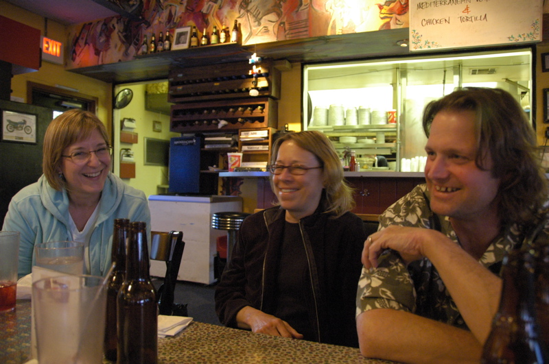
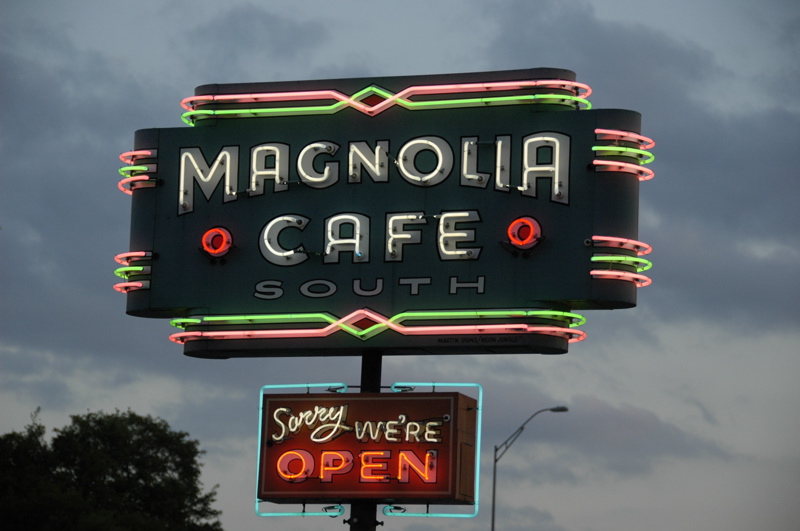
At lunchtime I was visited by John Irwin, who writes for Airstream Life magazine, and this evening we went out for dinner at the Magnolia Cafe on Congress Street with my friend Vicki, who lives here. We realized tonight that we’ve known each other about twenty years. Was it that long ago that we were cycling the streets of eastern Massachusetts together?
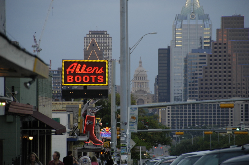
Austin seems to have a much higher ratio of neon-lit signs than other cities. I’ve noticed this in past visits but never had a chance to really get out at sunset and shoot the signs. Tonight I captured a few, and I hope to get out again on Thursday night for a few more.
Austin is a great town, with a really lively vibe. It has great food, lots of live music, and interesting people. Unfortunately, in some ways it is outgrowing its infrastructure. Traffic is often terrible. That’s another reason I’m glad we are able to stay in the heart of the city here at Pecan Grove. We’ll spend another couple of nights, so I can continue to get caught up on work, and then press on to Louisiana.
April 4, 2008 at 9:36 pm · Filed under Roadtrips
In the history of our travels, today will be recorded as one of those days that hopefully makes us stronger. Adversity is good for that, if nothing else.
When planning the return trip, I carefully considered the amount of pesos I had left. Everything in Mexico seems to require cash (in the entire trip I never saw an opportunity to use a credit card), and so I was careful to ensure that we had enough pesos for a full tank of fuel, plus the tollbooths on Rt 15, plus a little extra.
This would have worked out well if we hadn’t run into a speedtrap near the airport in Hermosillo. We were in the lead, with Adam & Susan following, and so intent on finding the first turn of the detour that we apparently coasted through a speed zone at perhaps 35-40 MPH. I saw a guy in a white shirt waving me to the left turn lane, who turned out to be a Hermosillo police officer.
He spoke no English and we speak virtually no Spanish. This was a worst-case scenario, because (as best we could determine), he felt we were facing a fine of 650 pesos (about $65) and, after confiscating my driver’s license, explained with much sign language that we were expected to drive to the central police station, pay the fine, and return to the scene of the crime with the receipt to retrieve my driver’s license.
Now, I can’t blame the guy for the communication problem, because we were in his country and hadn’t bothered to learn enough of the local language to make this process easier. He was being very friendly about the whole thing, and even started off the conversation with a handshake. But we could not conceive of how we were going to negotiate Hermosillo traffic to the police station, find parking for a 53-foot combination, and return to the side of the road, in anything less than a day or two. We also didn’t have an adequately detailed map of Hermosillo on us, since we only planned to pass through, and the GPS doesn’t contain city maps in Mexico. So it looked like a no-win situation.
We tried to call friends in the US for translation assistance, but of course Telmex did not remove the international call block on my phone as they had promised to do, so the phone was utterly useless in this instance. Fortunately, the police officer realized his compadre did speak some English, and the second officer was more sympathetic to our plight. He accepted 500 pesos, and gave us a receipt and my license back. We chatted a bit about his three kids, his trip to Disneyland, shook hands, and very carefully began to flee Hermosillo. At least the ticket is unlikely to be reported to my insurance company, so my rates won’t go up.
This episode wiped out most of the cash I had set aside for fuel, creating a new problem. We stopped at a Pemex station on the north side of Hermosillo, and I waved my only remaining peso bills at the attendant, a 100 and a 50. I made it clear that was the amount of fuel I wanted, verified he had zero’d out the pump, and stood by to make sure.
Then Eleanor called out, “We have a flat!” Sure enough, the rear curbside tire had a huge screw-like object embedded in the edge of the tread, and air was loudly hissing out of the tire at an alarming rate. OK, one problem at a time. I went back to the pump and found that the attendant had put in 200 pesos worth of fuel. I had a brief argument with him and once again waved my 150 pesos at him, and he just shrugged (not understanding a word of what I had said, I am sure) and waited.
I decided I had bigger fish to fry, so we dug up another 50 pesos in change, paid for the 28 liters of fuel with a scowl, and quickly backed the trailer into a quiet spot away from the pumps to change the tire.
My tire-changing skills have had a lot of practice lately. I can change an Airstream tire in less than 10 minutes working alone. With Adam’s help it was probably even less this time. The tire, however, was a total loss, so that was an expensive flat. I tossed it in the spare holder and made a note to get a new tire in Tucson.
At this point you can imagine that I was not especially cheery. Between the ticket and the tire our tab for driving through Hermosillo was about $180. Moreover, we were almost completely out of cash, our credit cards were just bits of plastic that nobody seemed to respect, and we were facing 180 miles of road and three tollbooths with no spare tire or money.
I considered stopping for the night at the same campground where we stayed on the way in, so that we could replace the wounded tire and perhaps find some money, but an overwhelming desire to get away from Hermosillo suddenly came over me.
The drive up Rt 15 is supposed to be pretty good. It is, after all, a toll road, and the fee for us to drive it was 156 pesos. For that you might expect a smooth road, but Rt 15 has been neglected too long and long stretches of it are riddled with bumps and potholes, and the parts that are not afflicted are covered in orange cones for the reconstruction work. The speed limit periodically dropped from 100 kph to 40 kph (about 25 MPH) for miles, and this drastically extended the trip. In all, our drive from Bahia Kino to Tucson took over nine hours, including stops for fuel, flats, bathroom stops, lug nut checks, and border delays.
This time, to avoid the nerve-wracking downtown Nogales roads that make you feel like you are a rock in an avalanche, we took the commercial truck route through Mariposa. The roads are better, but a few miles before the border we ran into a typically Mexican traffic situation. We found ourselves in a line of tractor-trailers parked in the travel lanes, waiting for … something … We could not tell what, and there were no signs to suggest what we were doing there.
After a few minutes, a man came by and gestured adamantly that we were to go into the left lane and bypass the trucks. We did so, very reluctantly, because the left lane turned out to be the median strip and it was barricaded by large concrete planters. We zig-zagged around these obstacles until we came face-to-face with a fence.
We sat there for a minute or two, absolutely bewildered, and finally observed a black SUV passing us driving in the oncoming traffic lane. It waited until there was no traffic coming, then scooted about 300 yards on the wrong side of the road and disappeared to the right behind a barricade. We realized we were expected to do the same.
So we did, and after the strange detour found ourselves in front of the immobile line of trucks. We waved to a guy with a big gun in an army uniform, who apparently had no interest in us, and continued on, wondering what the heck had just happened. Only a few hours earlier we had been fined $50 for driving too fast past the airport, and now here we were not only allowed to drive on the wrong side of the road against oncoming traffic, but actually encouraged to.
But at this point we were getting used to strange checkpoints and frequent contacts with officialdom. In all, we were stopped nine times by officials, once by the Hermosillo Police, twice at tollbooths on Rt 15, once at a military checkpoint, once at the commercial truck station, again at a third toll booth, twice at US customs (first at the entry point, then again for agricultural inspection), and finally by the US Border Patrol along I-19 in Arizona. We must be pretty clean by now, because everyone has had a good look at us.
Beside the speeding fine, we lost 231 pesos to the tollbooths, 20 pesos in tips to the guys at the gas station who washed our windows without being asked, and four raw eggs to the Agricultural Inspector. By the end, we were completely tapped out of cash and dipping into emergency dollars. My advice to those who would drive into Sonora: bring lots of folding money and don’t expect an ATM around the corner.
Thus it was a great relief to pull into the Shell station on the US side of the border and swipe the old credit card again. It’s always a sensation to come back into the USA from Mexico, because you are struck by the absence of trash by the roadsides, and the sudden disappearance of shacks and tortilla sellers along the roads. The lack of killer speedbumps (“topes”) is nice too. I liked Mexico but life is pretty convenient here in el norte.
We are home again in Tucson, for four nights. We need to move a few more things into the trailer for extended travel, clean the house, get a new spare tire, and finalize details with our house-sitters.
I’ll post pictures of the brutal huge screw-thing in our tire tomorrow when I get it fixed, and if we are lucky we’ll go on a nice hike up in the Rincons this weekend too.
March 30, 2008 at 8:52 pm · Filed under Roadtrips
Our departure from Tucson was dramatic. We cleared the driveway and street in front of our house of all vehicles except the two Airstreams, then parked Adam & Susan’s motorhome to the right, and David & Ariadna’s Safari 28 slide-out (identical to Bert & Janie’s) to the left. It’s a good thing we have great neighbors who not only tolerated us but actually got a kick out of it.
I was actually sorry to leave. The past few days have been terrifically fun with our friends, the weather has been spectacular, and the house is becoming very comfortable. Bert advised me that this was a good thing, because it meant I’d be happy to come back to home base. He’s got a point there. Adam said the same thing in a different way, “We miss every place we leave. There are too many great places. It’s a good problem to have.”
The “loose caravan” style worked well for our drive down to Nogales, 79 miles away. Crossing the border was a non-event, as it was the last time we entered Mexico. They use a red/green light system, and once again we got the green light, which means “drive on through.” The downtown border station is narrow and riddled with speedbumps so that you can only creep through at 5 MPH for a couple hundred yards. After that, we navigated the gauntlet of Nogales, dodging double-parked cars, slamming on the brakes for various obstacles (people, motorcycles, potholes), and hoping fervently that we made it through the town without any new scratches.
Once out of Nogales the drive is easy, even pleasant, and very scenic at times. We hung together, communicating by walkie-talkie, just because we weren’t sure where we’d stop. Highway 15 is a four-lane divided route, but the roughness of it meant that most of the time we were unable to match the posted 100 kph (62 MPH) speed limit. Only toward Hermosillo did the road smooth out, but by then it was getting late and so we decided to stop here rather than press on to Bahia Kino. Our total trip time: 6.5 hours, including innumerable bathroom stops for the kids, border crossing, fuel stop, one organizational meeting, and one wrong turn. That’s a lot of time to go about 250 miles, by US Interstate standards.
A tip for those coming down for the first time: bring lots of cash. The Pemex stations did not accept credit cards and ATM machines (el cajero automatico) were nowhere to be found. Also, to get to Hermosillo we passed through two tollbooths (cuotas) which totaled 156 pesos (about US$15). The campground here in Hermosillo also accepts only cash (US$20), so I ran through about US$100 in no time at all. Tomorrow I’ll find an ATM and get a pile of pesos out.
Tonight all three Airstreams are parked in a small (10-site) campground just off Rt 15 in Hermosillo. We can hear the highway, but the sites are modern, the utilities work just fine, and the wi-fi works. For $20 we’re all satisfied with it.
It looks like wi-fi will be the salvation of this blog. It’s very common in campgrounds here, probably because Americans really like it. It certainly gets my attention when the campground says “wi-fi”, even though I’m accustomed to it not working in the US campgrounds. Tomorrow we’ll head about 70 miles over to Bahia Kino and if we have wi-fi there, the blog will get updated.
February 21, 2008 at 10:33 am · Filed under Roadtrips
I busted out yesterday, with a big roadtrip to Las Vegas. I need to meet some folks here and there, so I put together a trip which will keep me out and about through Monday.
No Airstream this time, and no family either. We debated the ideas but neither made sense for this trip. I’ll be moving fast and light for a few days, and there are things to be managed back at the homestead. So Eleanor and Emma are in Tucson — still in the Airstream — taking care of things while I’m zipping around in the Fit trying to get my stuff done as quickly as possible.

First stop was near Prescott AZ to see “Peewee” Schwamborn, the son of Helen Byam Schwamborn. He was called Peewee because he was only 12 years old when we came along on Wally Byam’s first caravan, to central America. He ended up being on almost every major caravan Wally ran through the 1950s, and he has a huge treasure trove of artifacts and papers about Wally and Airstream.
Peewee, now more properly called Dale, was also a scout (at the age of 21) on the famous Cape Town to Cairo Caravan in 1959-60. He had an amazing life thanks to Airstream and Wally Byam. The last time I visited him he and I were laughing about how Wally Byam bought an Isetta microcar in Italy and Dale was elected to drive it from the docks in New York City to Los Angeles, at 45 MPH all the way. He’s got a million stories like that, and his archives are amazing. Dale’s photos and scans have appeared in Airstream Life magazine many times.

Dale, his mother Helen Byam Schwamborn, and Wally Byam’s Isetta
The drive through Arizona from south to north is very long, but I never find it tedious. My route, from Tucson to Phoenix and then Prescott, up to I-40 and west to Kingman, then up to the Hoover Dam, was over seven hours. But in Arizona the landscape keeps changing. Down south it’s saguaro and creosote bush, then urban traffic in Phoenix, then fast-rising mountains up to 5,000 feet into green forests. In Prescott it’s dry and cool, but very pretty with pink-orange granite dells everywhere. Along I-40 you’re in the kind of country that inspired the landscapes and scenes in the movie “Cars”, and then there’s an open stretch from Kingman heading north before you arrive at the Hoover Dam.
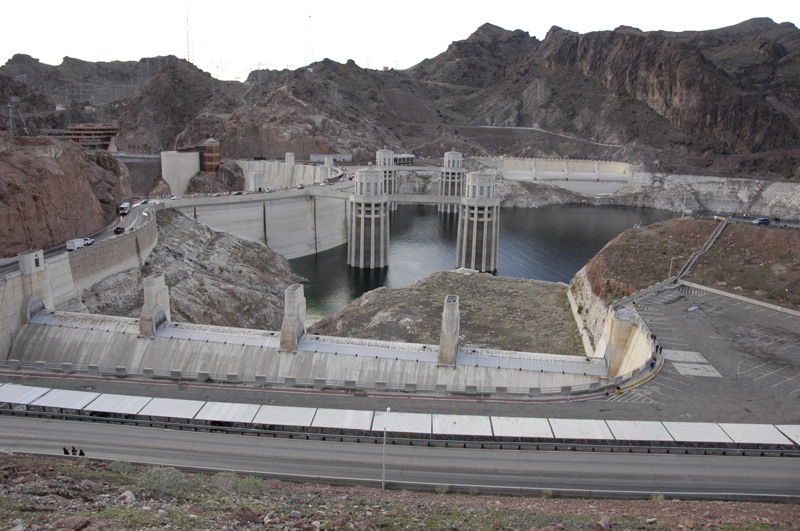
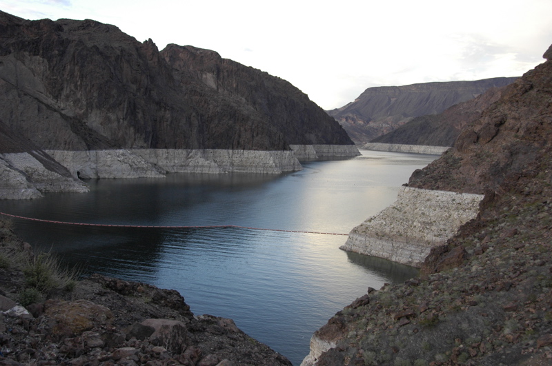
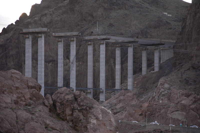
I always love crossing the dam. I look up to the new bypass they’re building, which soars far above the Black Canyon, and think that it will be a shame when I can no longer wind down to the dam and cruise across it at a leisurely 15 MPH. The bypass will have an astonishing view down into the canyon but I expect that traffic will never have a chance to slow down enough to see it.

The water in Lake Mead is very low these days. Every time I see it, it is a bit lower. Some scientists say this is a normal cycle for the lake, and others are predicting that with global warming effect the lake will be unusable by 2021. Who knows? But if it does run dry, Las Vegas is in trouble. The city gets 90% of its water from the lake.
I’ll be reporting from Las Vegas and the surrounding area for the next few days.
January 23, 2008 at 10:57 pm · Filed under Home base, Roadtrips
Just north of Tucson are the Santa Catalina Mountains, and up into those mountains is a road called the Catalina Highway. If you follow that road about 29 miles you will find yourself a lofty 8,000 feet above sea level. It’s an incredible thing, to depart the warmth of Tucson and arrive at a ski area — the southernmost ski area in North America — in less than an hour, with snow and pine trees and log cabin chalets everywhere.
The Catalinas are an example of “sky islands” which dot southern Arizona. By sticking up abruptly in the desert they create ecosystems that contain all the things you’d find a thousand miles north of here. I’ve wanted to go up to the highest point in the Catalinas, called Mt Lemmon, ever since we decided to settle in the area, and today I finally got a chance.
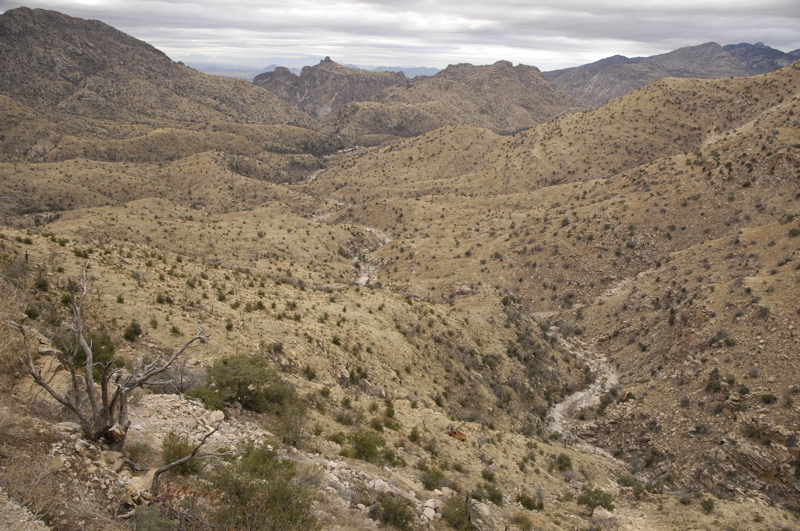
The road itself is a marvel. It twists and climbs through 5,000 feet in just a few miles, providing spectacular views from overlooks along the way. Half a dozen campgrounds are available too, although only one can accommodate RVs over 22 feet long. Several are for tents only. They look terrific for a hot summer day, located above 4,000 feet where the saguaros no longer can grow but where pine trees thrive.
 Although the first half of the route looks dry (and is, much of the year), there are numerous perennial waterfalls. Hiking trails are everywhere, or you can just drive from pullout to pullout and take in the views.
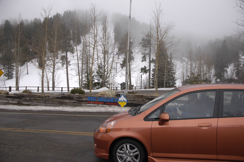
Above 8,000 feet there are numerous “cabins” on leased land in the National Forest. A lot of these cabins have been expanded to ridiculous size and made into (apparently) year-round homes. They form a small town called Summerhaven, which consists of one short main street, a few retail shops (general store, pizza parlor, gift shop, real estate office), and lots of residences either newly built or under construction. In 2003 there was a devastating forest fire up there, and so half the residences are being rebuilt, and it seems that money is no hindrance in many cases.
Near the center is a short spur road that leads to Mt Lemmon’s summit, the ski area and the ski area’s restaurant. The ski area is closed Tuesday and Wednesday even this time of year. It’s not a large place but it’s all we’ve got down here in southern Arizona. We’re lucky to have a ski area at all.
Being up there, I felt like I was back in Vermont or perhaps somewhere in Colorado. The clouds were blowing through and the temperature was in the upper 20s or low 30s at best. Crusty snow was everywhere. I had to remind myself that only 29 miles down the hill we’d be back in Tucson, AZ.
 This evening we went out for Vietnamese food, which was great, but they’ve started supplying fortune cookies like Chinese restaurants. When fortune cookies are handed out, I always seem to get the lamest fortune. This was no exception.
What does this strange little slip of paper mean to tell me? Is this good fortune or a prediction of a long and difficult life? Does this have anything to do with the fact that Eleanor doesn’t tow the trailer? And what do I win at the end?
One other thing: a couple of weeks ago we launched the Airstream Life Media Community. It’s a free service which allows you to share Airstream-related photos and videos with other people. There are already about 70 photos uploaded and several videos, and I’d like to encourage more. Check it out and upload your favorite Airstream pictures or even short videos! The more, the merrier!
« Previous entries ·
Next entries »