Archive for Roadtrips
September 27, 2008 at 10:43 am · Filed under Roadtrips
“There’s not much there,” I was told about the Navajo country, by somebody in Utah. That’s true in the sense that there is little in the way of tourist traps, adventure tours, and shopping malls. But as it turns out, the absence of “things” is part of the interest of the area. There are fewer signs of man, which makes the ones you do see more obvious.
The Navajo Nation is a study in the collision between traditional and modern life, and so almost every little thing tells a story. Little hogans (traditional round houses) sitting next to 20th century mobile homes are everywhere. Everyone drives pickup trucks, but horses roam free by the roadside. In canyons people live by traditional means, but just above them on the mesa their neighbors have a satellite TV.
Across from the entrance road to Navajo National Monument is a coal mine, which pumps out coal from the Black Mesa to feed the Navajo Generating Station in Page, 80 miles away by electric train. The power station eats 1,000 tons an hour of coal, and it all comes from the mine near Shonto, in the heart of Navajo country.
 Driving east on Rt 160 from Navajo National Monument, you soon come to a turn in the road where you must decide if you are heading north to the famed Monument Valley (setting of many a western) and into Utah, or continuing south-east to Canyon de Chelly. Since we started our great circle tour of national parks up at the intersection of the Four Corners, and are heading to Albuquerque, our choice was obvious.
The ride, along Rt 160 and Rt 59 is stark but beautiful. It is designed to bore children and people who are mostly interested in their next shopping opportunity, but we liked it just fine. We stopped in the small town of Many Farms at the intersection of Rt 59 and 160, and caught up on our laundry at the combination gas station/convenience store/ laundromat.
This was really the first time we’d been among the local people in a normal setting. I don’t count the interactions with weavers and painters at the national monument, because they are sort of “on show.” There’s nothing like a laundromat to bring everyone to the same level: we’re all just there washing our clothes, being regular people. Like many towns, the people we encountered ran the gamut.
A panhandler knocked on the door of the Airstream looking for a dollar, while we were getting the laundry together. From his eyes and general appearance I would have to say he was an alcoholic. In the parking lot a crew of two was working hard on some maintenance task, in the convenience store a steady stream of people came and went (including Navajo, white missionaries in ties, and traveling businessmen from outside the reservation), and in the laundry young women were tending to their laundry with toddlers running around their feet. In short, it was just a slice of modern life.
I may have been looking for something else, but really, at laundromat sitting at the intersection of two highways, there’s not much else you could expect. The inner workings of the Navajo community aren’t on display everywhere. So for a glimpse into the community, I bought the local paper (Navajo Times) and read that while the laundry spun.
The Navajo Times is surprisingly well-written, for what I would guess is a relatively small-circulation publication. I’m used to local newspapers being total rags, filled with generic wire stories and relatively little local news. What there is of local news is usually badly written by underpaid recent college graduates. The Navajo Times exceeded my expectations. It appears to hire reporters who actually do their research and write readable articles.
The subject matter, however, was discouraging. Of the lead articles, most were related to various people attempting to scam others. A real estate agent from out of state, already arraigned in court in Montana on bad-check and fraud charges, showed up in the community of Teec Nos Pos and scammed locals with promises of a resort development. The Speaker of the Nation is embroiled in a scandal with an architect who says he was cheated out of $250k in fees “” it’s not clear who is scamming who. A local woman who donated land to the airport now says the town has taken more of her land than she agreed to “” she doesn’t read or write but somehow managed to sign a contract. It all sounds like history repeating itself. Battles over land and money continue.
It’s not far from Many Farms to Chinle, the town that forms the gateway to Canyon de Chelly. We pulled into the national park campground, called Cottonwood in the early afternoon (carrying lots of fresh laundry at last) and settled into a site that has good sun coverage most of the day. We’ve been running on solar power since a week ago Thursday, with great success, and we don’t expect to see a power outlet until at least Monday.
There is cell phone coverage in the area of the campground and visitor center, but it is an independent operator and so for most people calls will incur “roaming” rates. We won’t be making any calls in the next couple of days. We also found a pleasant surprise: the Thunderbird Motel, which borders the campground, provides free wi-fi. We can pick up the signal from the Airstream since we are parked very close to the motel, so once again I can keep the blog updated in a place where I felt I would have no chance of getting online. Today we will do some exploring of the canyon, and I’ll tell you about the unique features of this particular National Monument.
September 22, 2008 at 2:19 pm · Filed under Maintenance, Roadtrips
Leaving the Grand Canyon’s north rim to Page AZ is one of those spectacular roadtrips that can only be found in Arizona or Utah. From Grand Canyon you cruise along Rt 67 to Jacob Lake, a small outpost in the Kaibab National Forest that is a nice destination in its own right but massively overshadowed by the Grand Canyon 47 miles away.

 From Jacob Lake the road descends on Alt. Rt. 89, passing from Ponderosa pine forest, past gorgeous views of the Vermillion Cliffs, and eventually to high desert. At a viewpoint near the Vermillion Cliffs, just after entering the Navajo Nation, there is a large pullout where Navajo women have set up stands to sell art and crafts made by dozens of Navajo artists they represent. The stop is worth making just for the views of the Vermillion Cliffs — the best view we’ve seen yet — but the items for sale are also beautiful.
A bit further you pass the little outpost called Cliff Dwellers, where there is a small motel, a restaurant, and a few homes butted up against the red stone of the cliffs. Amazingly, fly fishing in the perennial streams of the nearby canyons seems to be the major attraction of Cliff Dwellers.
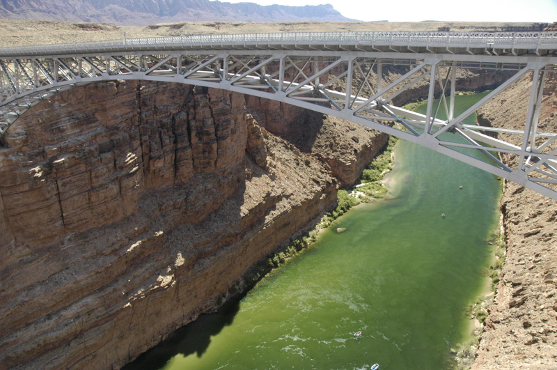
The road bottoms out at about 3,000 feet at Navajo Bridge, which crosses the Colorado River at a narrow spot above a very tall gorge. The bridge, originally built in the 1920s, is a steel arch type which appears to hang 700+ feet above the deep green water of the river below. Actually, it was replaced in 1995 by a larger but nearly identical bridge, and so you can now walk across the old bridge for the view. Well worth the stop, but keep in mind that there’s no RV parking. We “invented” some along the exit road and the ranger on duty did not mind. There are covered picnic tables near the bridges so it makes a nice lunch stop.

From Navajo Bridge the road climbs again to the south, until Alt Rt 89 joins Rt 89 and you have a choice: Flagstaff or Page. We turned left (north) to Page and immediately began a climb through the red cliffs where pullouts give you an outstanding view of the plateau below. The road slices through a notch in the cliffs and you’re back up at 6000 feet. Then it slowly descends down a tilted plateau to Page.
Page was originally a workers town for the builders of the Glen Canyon dam that formed Lake Powell. When the dam was proposed, there weren’t any towns for 80 miles, no roads, and no rails. Today it’s a modern town with golf courses and marinas on Lake Powell, but it’s still a long way from anything. This, plus the fact that it is located smack in the middle of some of the most beautiful landscape in the southwest, makes it a popular stop for RV’ers.

The National Park Service offers a free 45-minute tour of the Glen Canyon dam, and this is another stop well worth making. The views from the bridge and from the Visitor Center are breathtaking on a nice day — and it’s usually a nice day out here. Emma snagged a Junior Ranger badge there, too, in about 90 minutes.
The last time we were here we stayed at Wahweap Marina on the shore of Lake Powell. It’s a very nice spot, but this time we wanted easy access to services. The Super Wal-Mart on the main road is unbelievably convenient, with a Shell station across the street that has an RV dump, fresh water, propane, gas, diesel, and air. We needed three of those things, plus a bunch of supplies at the Wal-Mart.
Last night while taking a shower I noticed the water was extremely sluggish going down the drain. Not surprising, since I live with two females who have long hair, and we have to take apart the bathroom sink trap two or three times each year to remove clogs of hair. But the shower drain is not as accessible, which is why we always have a small screen in the drain to catch hair. So what was the problem?
We tried a jug of liquid drain stuff last night but there was no effect at all. This morning we ran into the Wal-Mart for a snake, and it was a bomb too. It hit the pipe walls at the trap and wouldn’t go any further. Then we got a plunger and applied some effort with that.
The plunger yielded some small improvement, plus a lot of sand regurgitated by the drain. Aha! We washed off some dirty feet back at Great Sand Dunes National Park last month. We think that, combined with the other things that go down the drain, the sand had formed a clog that corrosive drain cleaners couldn’t touch.
At this point the shower is usable but still slow. We could have an Airstream dealer take apart the drain (requiring opening of the belly pan beneath the trailer), but first we’re going to try to use the water hose at the Shell station to push the sand through the trap. That requires removing the lower half of the bathroom window, then the screen, so we can snake the hose into the bathroom, but I’ve done it before and it should be reasonably straightforward. This is what on-the-road maintenance looks like sometimes.
September 9, 2008 at 10:52 pm · Filed under Roadtrips
 Our goal today was to drive 118 miles from Capitol Reef to Bryce Canyon, via Utah’s semi-famous Route 12. This route goes through parts of the Dixie National Forest and the northern edge of Grand Staircase-Escalante National Monument (BLM). We’d been told it was an eye-popping drive, but unfortunately the weather was uncooperative and a lot of the views from 9000 feet and above were obscured by passing rainshowers and fog.
Coming down past Boulder, the view improved. We had considered stopping at the Calf Creek BLM campground, but passed it by with a note to perhaps visit it on another trip. It’s located down in an absolutely beautiful canyon, not far from the spot we were overlooking in the photo at left.
I must be getting used to driving out here on the Colorado Plateau. We rolled up and down grades ranging from 8% to (briefly) 14%, climbed above 9000 feet on curvy roads with no guardrails, in and out of rainshowers, and my reaction to most of it was “ho hum…” Not that it wasn’t beautiful, but the adrenaline rush that usually accompanies towing under such conditions was distinctly muted. Mostly I toodled along, one hand on the wheel, one hand on the transmission stick, thinking about when we should stop for lunch.
Which eventually we did, at the visitor center in Escalante. While we were parked there, we ran into Rick, another Airstream full-timer traveler who has been out on the road for about three months so far. He’s got a sweet 1976 Airstream 30 footer that he refurbished and customized. We hung out for a couple of hours, swapping travel notes, and may meet up again later this winter. Rick’s blog is a bit out of date but he’s planning to get caught up on his latest travels.
With all the puttering, we didn’t get to Bryce until about 5 p.m. The national park’s campgrounds were mostly full, and the few remaining spaces were either too short or very unlevel. The entire North campground seems to have been built on a hill. Also, the site were entirely shaded, which would give us no useful solar power. We decided to go upscale and pay for Ruby’s campground just outside the park entrance.
This is a big luxury for us. We’ve been camping without hookups of any type for a week, which has allowed us to stay close to the parks we’ve been visiting. Upgrading to a commercial campground is like splurging on a five-star hotel. We’re getting full hookups, wifi, a laundry, two swimming pools, two restaurants, and my phone works too. We’ll catch up on laundry, work, email, phone messages — all those annoyances of “real life” –and work in a few hikes in Bryce too.
September 1, 2008 at 1:13 pm · Filed under Roadtrips
Early Sunday morning the rain began in Silverton, a tap-tap of fat drops that steadied into a drizzle by the time we got out of bed. This rain had been forecast, but the Silverton forecasts are often wrong (I was told), so I had hoped it would not come.
Our task for the day was to drive back along the Million Dollar Highway to Durango and then to Mesa Verde National Park. This is the same highway we arrived by, which meant again we needed to cross two very high passes with steep ascents and descents: Molas and Coal Bank. Now the task was complicated by wet roads and occasionally dense fog.
So we prepped everything, donned our rain gear, and said goodbye to Mike and Tracy. We expect to see them again over the winter in Tucson and perhaps Quartzsite, and even Silverton next summer.
Like bats before flight, we first stopped at a nearby campground to offload about 200 pounds of black and gray water. (Campgrounds will usually allow you use of their dump stations even if you aren’t staying there, for a fee, in this case $5.) Two hundred pounds may not seem like much in the context of a combined rig that weighs closer to 14,000 pounds, but amazingly it does help a bit with the power when climbing 7-8% grades for many miles.
Since driving conditions had the potential to be nerve-wracking as we wound up and down the steep grades with few guardrails, everyone kept silent. This is a technique used by airline pilots (the “sterile cockpit” rule, which says that there can be no unnecessary chatter on the flight deck of an airliner below 10,000 feet), and it really helps. I got the rig into a nice steady groove in second gear as we climbed out of Silverton, and we rolled along steadily until the road finally straightened out 20 miles later.
Steady is the key. A road like this is constantly inciting you to speed up on descents and slow down on ascents & curves, and if you give in to it you will find yourself either standing on the accelerator or brake nearly all the time. This is hard on the rig and can easily lead to loss of control. Remember, you’ve got thousands of pounds of cargo behind you, just aching to push you sideways on a descending turn. On a climb the engine or transmission can easily be overheated. And brakes will fade to worthlessness once they get too hot.
So we used every advantage we had. The Hensley hitch kept the trailer straight, we stayed in second gear the entire time for engine braking, and I tapped the disc brakes lightly on the descents when engine braking wasn’t enough. I kept the speed within a band from 15 MPH (on the hairpins) to 35 MPH, and watched the RPM gauge to keep the transmission in its ideal range for cooling.
Cars and motorcycles stacked up behind us, and would occasionally pass in suicide maneuvers. The entire road is a no-passing zone, for good reason. The speed limit is generally 30-35 MPH and much slower in curves. There are few pull-outs, so most of the time there’s nothing you can do about impatient people who want to shave two minutes off their trip. If you find yourself in this situation, don’t let pressure from vehicles behind cause you to drive beyond your rig’s abilities. If you are wrecked on the side of the road after going too fast on a wet foggy mountain pass, will they stop and take responsibility for it? Will they go to the hospital on your behalf, or buy you a new truck? Unless you are sure the answer to all these questions is “Yes,” let “˜em wait, or use the next available pull-out.
The only really intimidating part of the ride was one point when we were descending to a steep hairpin turn in dense fog. I could not see the turn even two hundred feet from us, but fortunately the GPS map showed me it was coming, and being in fog I already had the Nissan and Airstream slowed down to 20 MPH. Steady as she goes.
I’ve mentioned before not to trust the GPS when going to state or national parks, but I’ll say it again. Coming to Mesa Verde from the east, Garminita wanted us to exit the highway onto a dirt road named “H-5.” Knowing that she tends to get excited when we approach a national park, I disregarded this and continued another mile down the road to the proper (and well-marked) exit. Good thing, since H.5 doesn’t go anywhere. I pity the RV’er who follows that direction from their GPS. Attempting a U-turn on a narrow dirt road (or worse, backing up a half-mile) is not fun.
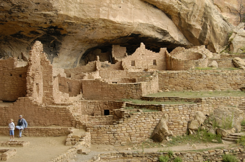
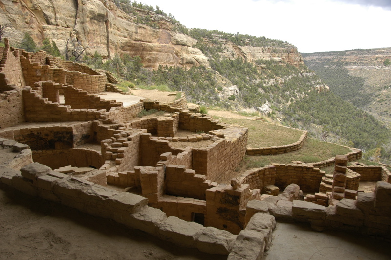
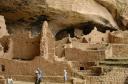
Mesa Verde is a large park containing over 600 cliff dwellings, 4,200 other ancient dwelling sites, and many miles of twisting roads. Those roads connect to just a handful of sites that are open to the public, and trailers or motorhomes with vehicles in tow can’t traverse them. Motorhomes over 25 feet long or 8000# GVWR are prohibited entirely from the road to Wetherill Mesa.
Even after driving five miles into the park to set the trailer in Morefield campground, it was another 11 miles to the Visitor Center, and an additional 12 miles to Wetherill Mesa, where we took our first tour of a cliff dwelling.
I had chosen to stay in the park at Morefield because (1) we always like the national park campgrounds for their convenient access, low prices, and generally attractive settings; (2) the NPS website said, “It never fills,” so even on Labor Day weekend we didn’t need to worry about reservations. Alas, Morefield was a slight disappointment. Now I know why it never fills. The price when we arrived was not $14 as published on the website, but a startling $24.05 per night. That’s a lot for an unlevel, weedy, primitive site (meaning no hookups). Bathrooms are nearby, but showers are inconveniently located over a mile away. Still, the location is at least five miles closer than the nearest commercial campground.
Since we arrived in Mesa Verde in the early afternoon, there was time to explore one end of the park. At the Farpoint Visitor Center, the road forks into two. One road leads 12 miles to Wetherill Mesa, and the other road leads 5 miles to Chapin Mesa. Although the distances don’t seem long, the twistiness of the roads means that the 12 mile drive to Wetherill takes about 30 minutes. Since there are multiple sites to visit at both mesas, and the drive times are long, it’s impossible to see everything in one day.
We caught the last (4 pm) tour of the day at Long House, the second-largest cliff dwelling in the park. It’s also the longest tour, at 90 minutes. This visit made up for the tedious drives of the day, because Long House is just spectacular. With overcast skies in the afternoon, the light was perfect. Inside the dwelling I used bounce flash to fill in a few shots, but for the most part it was just natural light. I shot over a hundred images and wished I’d had time for many more. I’ll be setting up a new album on Flickr for some of my favorites.
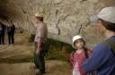

Getting to Long House requires a tram ride, a steep set of stairs, and a hike of about half a mile. Exactly at the end of the tour, the skies opened up and a deluge started “¦ and of course, being optimistic, we left the rain jackets back in the car. We weren’t the only ones. Half a mile later, about a dozen of us arrived at the tram stop utterly drenched, and then sat down on the flooded plastic benches of the tram for a soggy open-sided ride back to the parking lot.
The rain meant there was no chance of us attending the Ranger talk in the amphitheater at Morefield campground, so we dragged our dripping selves back to the Airstream and fired up the catalytic heater to maximum. If there’s any fun in getting soaked in the rain, it’s the moment you take off all the wet clothes and put on dry ones, while standing in front of a toasty heater.
We hung our wet stuff in front of the heater, including our shoes and Emma’s stuffed cat Zoe (she goes along for every hike and really doesn’t like getting wet), and watched a movie while eating pecan-crusted boneless trout filets that we bought at the Great Machipongo Clam Shack in Virginia last May. That made a fine end to a long and wild day, and it felt well worth the trouble of towing the Airstream over the mountains to have it waiting for us with warmth and dinner and comfort.
August 28, 2008 at 11:38 pm · Filed under Roadtrips
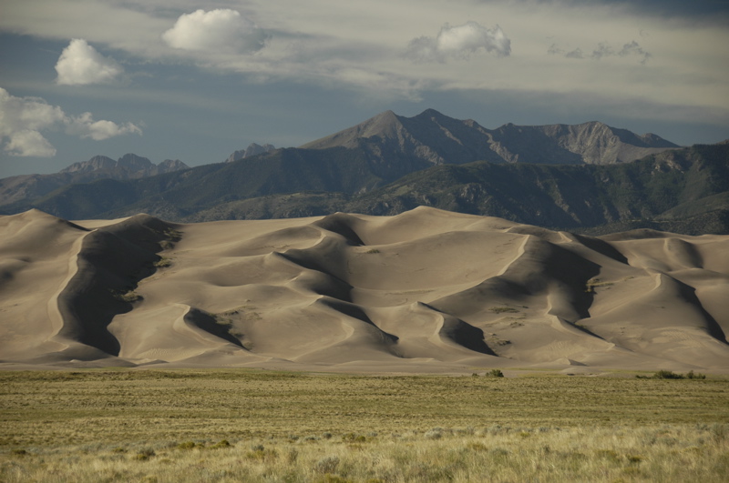
We have departed the Great Sand Dunes for points west.
This has been an incredibly convenient park. Near the campground they not only have a recycling center, a bear-proof trash drop-off, a dump station, and good-tasting water, but also compressed air. It’s provided for people who have had to lower their tire pressure when driving on the sandy 4WD roads. I took the opportunity to get all of the trailer’s tires to exactly 65 psi cold, and then we headed over to the Visitor Center to show the rangers Emma’s efforts in the Junior Ranger booklet.
 The rangers were suitably impressed with her work and her drawing of the dunes, and the fact that she had been in the park for three days. So they awarded the ultimate bonus of the Junior Ranger program: both a badge and a patch.
Our goal for the day was Silverton, where our friends Mike and Tracy live. It’s not on the way to anything we had planned to see, but the opportunity to enjoy their hospitality and local guidance was worth wandering 50 miles off course.
Driving around Colorado means you’ll eventually have to cross a mountain pass. The big ones all have names, and you’ll remember them, because each pass has its own personality. They vary in steepness, length, height, and fear factor, but they are all memorable.
In our travels we have crossed some doozies. Slumgullion Pass on the road between Durango and Creede was really a nail-biter. Monarch Pass was memorable for the aerial tramway we rode at the 11,000 foot summit. At those altitudes the gas-powered Nissan doesn’t put out its full power, so we generally gear down to 2nd and roll up the mountain grades at 35 to 40 MPH. That’s fine, since the speed limits on the twisting state highways leading toward passes are usually about 45 MPH, and slower in the hairpin curves.
Today we set a record: three passes in one trip segment. The first was Wolf Creek Pass, about 9,400 feet. The second was Coal Bank Pass, at 10,600 feet, and the third (right on the heels of Coal Bank) was Molas Pass at 10,800 feet. At Molas the summit feels like you’re on the top of the world. Ten thousand foot peaks are scattered around below you, and vast deep valleys are far below.
Of course, what goes up must go down, and that means four or five miles of 7-8% descent. That’s enough to smoke your brakes if you aren’t careful. Our procedure has been to keep the truck in 2nd and tap the disc brakes once in a while to keep the speed under 40 MPH, and 25 MPH in the curves.
Coal Bank is right up there with Slumgullion for sheer terror. Much of the road involves incredibly long drops off the non-existent shoulder, and there are few guard rails. Cross the white line with a wheel and it will be the last thing you do. I kept my eyes focused on the road and tried not to look down the steep embankments, although Eleanor was right there with a running commentary about the cliffs.
After that experience, we were glad to wind down into the little former mining town of Silverton, where Mike and Tracy live part of the year in a little century-old house on the main street of town. (When they are not here, they’re off in their Airstream Classic motorhome, which for the record goes up Coal Bank Pass at about 20 MPH. Mike says, “I’m the guy I used to be stuck behind when I was younger.”)
We’ve been given a fine courtesy parking spot next to the house, and an invitation to stay up to 20 days, the legal limit here. We’ll probably stay two or three days, although I could certainly yield to the temptation to stay longer. Even with only a couple of hours before sunset, I could see that Silverton has a lot of things to explore: historic architecture, hummingbirds, hiking, 4WD explorations, abandoned mines, local characters, etc. We’ll start checking it all out on Friday.
August 20, 2008 at 6:03 pm · Filed under Roadtrips, Travel / lifestyle musings
We’ve been pondering the choices ahead, and have made some decisions. Mostly, we’ve decided that the opportunity to go explore a bunch of the country’s best national parks in late August and September is too much to miss. The Four Corners region is one of the most densely packed areas of national parks, and some of the most famous and beautiful ones are here. We don’t know when we’ll get this chance again.
If we head straight back to home base, we’ll have about 850 miles to drive and we’d see maybe three or four great spots along the way. But if we take a convoluted route of about 1,500 miles through southern Colorado, Utah, and northern Arizona, things get considerably more interesting. We will get to visit:
- Great Sand Dunes National Monument and Preserve
- Mesa Verde National Park
- Hovenweep National Monument
- Yucca House National Monument
- Natural Bridges National Monument
- Canyonlands National Park
- Capitol Reef National Park
- Bryce Canyon National Park
- Grand Canyon National Park (north rim) (Not shown on route map)
- some of Monument Valley
- Navajo National Monument
- Canyon de Chelly National Monument
- Petrified Forest National Park (previously visited)
- the White Mountains of northern Arizona
The added mileage will cost about $300 in fuel. We’ll also spend about $400 in additional campground fees. For that we’ll get four or five weeks of travel through 11 national parks. That’s a heck of deal for $700. Since we are spreading the cost out over a month, we can afford it more easily. It’s about $20 per day.
The real consideration is keeping up with work. The western national parks are generally out of range of cellular Internet and voice. A few campgrounds have wi-fi (which we know from past experience is unreliable), and a few spots can be reached from towns with cell phone service like Cortez CO. We’re going to have to juggle work and play carefully.
The idea is one we’ve used all along. When things are quiet, we scoot into a national park and drop off the network for a few days. Then, we drive to the nearest place where I can get online and Eleanor can catch up on groceries, laundry, etc., and settle in for a few days of work and homeschooling. Three or four days later, we move on to the next remote park and repeat. The challenge in the four corners region especially is that there’s a lot more “remote” territory than anything else.
It’s also much more expensive to park in a wi-fi enabled campground than in the national park campgrounds we favor, usually by a factor of two. Since we are trying to compensate for higher fuel prices, we’ve been tending to free and cheap campsites more than usual. The work periods will drive up our expenses. That’s a good motivator for me to get the jobs done as quickly as possible. Efficiency pays when you’re working and full-timing.
With all these competing factors, we can’t say we have a firm plan, only a route and a set of guidelines. So we can’t make reservations. We’ll just have to wing it, as usual. Sounds like fun to me.
August 16, 2008 at 9:24 pm · Filed under Roadtrips
I suppose if I must have a cold while trying to cross a broad swath of the USA, Kansas is a good place to have it. That’s because I can never equalize my ears when I have a cold. Nothing works for this problem, including medications and various techniques used by divers. So typically a cold means I am restricted to one elevation until it clears up, and absolutely no flying.
Fortunately, the drive east to west across Kansas is a gentle rise most of the way. We pulled out this morning from our quiet and scenic spot by the lake near Baldwin City at about 1,600 feet elevation, and eventually ended up here in Goodland at 3,700 feet. That climb — if you can call it a climb — was spread over about 300 miles, or about 3.6 feet elevation gain per mile. Nice and gradual, and easy on the three people in the car who have colds at the moment.
Yes, now there are three. Emma started having symptoms last night. Only Eleanor has so far escaped the viral wrath from Florida. After two long days in the car I thought Emma would appreciate a short day today, with lots of breaks to run around, but when she got the cold we changed the plan. There’s nothing like a virus to take the edge off a kid. She was happy to spend most of the time sitting in the car playing with her toys, and I was happy to have Brett as chauffeur for most of the day.
Goodland is a nice place to stop along I-70. We’ve been here before. The town is big enough to have good services, and small enough that there’s not much traffic. Since we have only 200 miles or so before Denver, we’re going to spend sometime here on Sunday to explore the various sights in town.
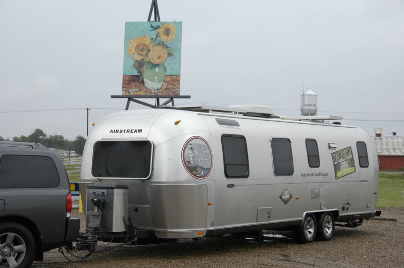
Tourist attraction: The giant Van Gogh reproduction in Goodland KS
Maintenance report: I think there is something wrong with the auto-leveling system on the Armada. It has a factory-installed airbag suspension in the rear, but it appears to have a slow leak. We’ll check that in Denver at a Nissan dealer.
Solar report: We’ve been running on battery since we left Jackson Center, with all three fans running all night and lots of light and water pump usage. We haven’t been frugal with our power at all because there has been abundant sunshine to recharge the batteries. This afternoon the batteries were at 81%, not bad. It’s summertime and the livin’ is easy … on solar power.
Next entries »
 Driving east on Rt 160 from Navajo National Monument, you soon come to a turn in the road where you must decide if you are heading north to the famed Monument Valley (setting of many a western) and into Utah, or continuing south-east to Canyon de Chelly. Since we started our great circle tour of national parks up at the intersection of the Four Corners, and are heading to Albuquerque, our choice was obvious.