Archive for Places to go
October 9, 2008 at 11:19 am · Filed under Maintenance, Places to go
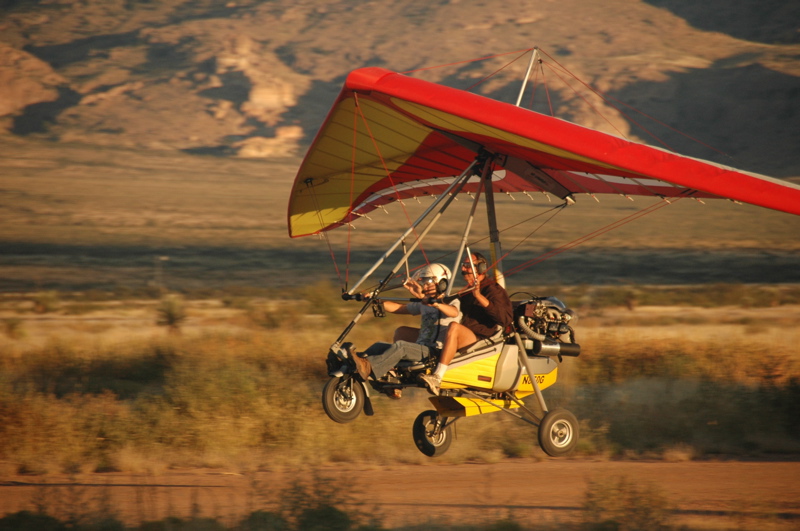
Our last(?) stop before Tucson is an assignment I’ve given myself, for the magazine. There’s a little airpark in the very remote town of Rodeo NM, where a group of “Sky Gypsies” fly light sport aircraft from a 7200 ft packed dirt airstrip. While I like flying, the real reason we are here is because this park contains a small array of vintage Airstreams, polished and arranged in a semi-circle next to the runway.
This is the fun part of my job. I interview everyone I see, take a lot of pictures, and then write up the experience for the blog and (eventually) the magazine.
 The Airstreams are housing for members of the park association as well as students who come here to get certified to fly light sport aircraft. Neil Bungard teaches these folks in Air Creation planes every morning and evening when the air is relatively calm and the temperatures are moderate. It takes about 28 hours of flight instruction to get certified, and so having the Airstreams as temporary housing is handy.
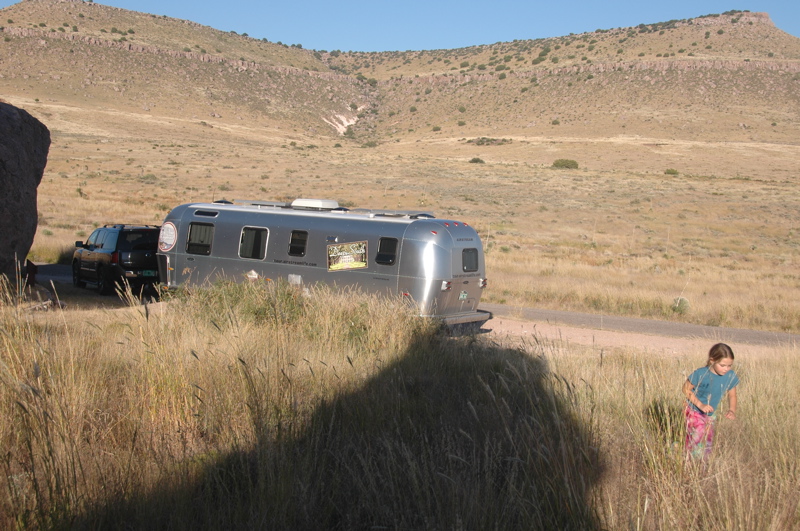
 We parked our Airstream in the gravel lot adjacent to the field for a night. There are no hookups and no formal transient spots for visiting RV’ers, but plenty of room to just dry camp. At night it’s very quiet, but in the morning and evening it’s nice to hear the sound of little aircraft engines practicing touch-and-goes on the runway. For a pilot, aircraft noise is a good thing.
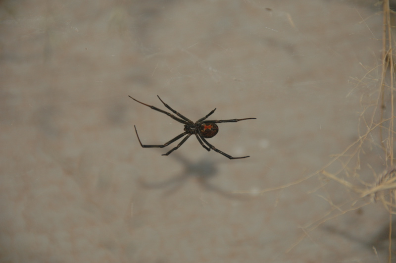
We’re 30 miles from a very lonely stretch of I-10 out here. This is a quiet corner of New Mexico. It’s 60 miles to a grocery store. Apparently it’s a popular place for retired astronomers to go, since the night sky is very dark and clear. It’s also a great place for observing the natural desert world. There are lots of interesting creatures here, including giant grasshoppers, tarantulas, and javalinas. Emma found a black widow spider last night, which was exciting for her but then caused her to worry they’d climb into the trailer while she was sleeping.
Coming into the park requires a half mile drive down a washboard gravel road. When making a 90-degree turn at low speed on this road, the right rear tire of the Nissan blew out. (The on-board Tire Pressure Management System that comes with the Nissan was no help at all — it alarmed 30 seconds after the tire blew out.)
I’ve been watching the Nissan’s tires for a few months. They are nearly worn out after about 40,000 miles, and my plan was to replace all four when we reached Tucson. Apparently I waited a bit too long. This one seems to have failed as a result of wear, sharp rocks, and the added stress of carrying a trailer. There was a two-inch long rip in the tread, emanating from a central failure point. There was no sign of a nail or other object (other than rocks) that caused the failure.
We put the spare on but it’s a solid 80 miles to the nearest tire shop, so I am taking a few steps to reduce the risk of the other rear tire going. We are going to transfer some cargo from the Nissan to the Airstream to lighten the tire load, and increase the rear tire pressure slightly. We’ll also keep the speed down on the highway today, although lately we never tow over 62 MPH.
October 8, 2008 at 2:15 pm · Filed under Maintenance, Places to go, Travel / lifestyle musings
From Albuquerque south we made very few stops yesterday. We paused for lunch and a water fill at a truck stop along I-25, then for chiles in Hatch, and not much else. It’s a peculiar feeling to know that we are headed somewhere to stop indefinitely, and I think that contributed to a sense that we had no particular purpose for being on the road.
When you don’t know where you are going, it’s helpful to stop and take stock. So we pulled into City of Rocks State Park in southern New Mexico for a night. Eleanor and I remember City of Rocks from our only previous visit, in early 2000 when Emma was still a womb passenger. I remembered thinking back then that we should come back sometime and camp with a tent, but we never did. Finally, we’ve come back with an Airstream and an 8-year-old. The rocks are the same, but everything about us seems different.
Along the road yesterday I noticed that we’ve once again broken a belt in a trailer tire. That’s (I think) the fifth one in a year. This particular tire was a TowMax Power King, which is sold by Les Schwab tire stores. At this point I have not found any brand that seems to last longer than any other. The TowMax on the other side is still holding up fine, as are the Goodyear Marathon and Carlisle, but none of them are older than a year.
The tire appears usable for now. The broken belt is revealing itself by unusually fast wear on the outer edge. In about 500 miles it will be bald there, but I’ll replace it before then. Since we had the axles aligned in August, I’m fairly sure that this is not an alignment problem, but there will be no doubt when we remove it. A broken belt causes the tire to bulge out along the tread, which is what causes the rapid wear. I’ll take pictures of the tire when it is removed, so you can see what I’m talking about.
 We’ve got one more stop to make on this trip, in the remote town of Rodeo, NM. It’s a tiny place 30 miles south of I-10 in a very lonely corner of New Mexico. There’s an ultralight airport based there, run by a group of flying fanatics. Students who come down are housed in Airstreams parked on the property. We’re going to head down there tonight and spend some time learning about the place and the people who run it. I may even get a chance to take a ride in one of the ultralights.
After that stop, we will head to Tucson, wash the trailer at a local truck stop, and then park it. It needs some maintenance. We’ve got a list of about a dozen things to do for it, including repairs, upgrades, and cleaning.
I have decided to extend the blog for a bit longer. In addition to having maintenance tasks to talk about, there are things that need to be said about the process of coming off the road. It’s a very emotional change for us, and I don’t want to underplay the significance of it. I also want to summarize some of my feelings about the past three years. Stopping travel (even for a little while) is a part of the process of full-timing, so it seems legitimate to continue the Tour of America blog long enough to cover all of those items.
This is a chance for you to ask questions, too, so if there’s something you’re wondering about, ask away! I’ll blog our return to suburbia and all the other things over the next few days.
October 4, 2008 at 6:10 pm · Filed under Places to go
Yesterday we met with 28 other Airstreams at the Camping World on I-40, and the entire line of aluminum caravanned together to the Balloon Fiesta Park on the north side of Albuquerque. From a gravel lot overlooking the Balloon Fiesta field, we will spend four nights watching all things related to hot-air and gas ballooning going on. This is our final blowout adventure of this season of travel.
The danger of attending the famous Albuquerque Balloon Festival is that you’ll take too many photographs. Actually, it’s inevitable. The balloons are so colorful and scenic that you can’t stop at, say, 100 photos. I got up in the 5 a.m. darkness to scout a location for photos of the “Dawn Patrol,” and by 8 a.m. I had filled a memory card with over 300 photos. Don’t worry, you don’t have to look at all of them. You can see some of them on Flickr by clicking here.
This is also an event designed to mess with your Circadian sleep cycle. Everything happens between 5:45 a.m. and 8:30 a.m., then again from about 6 p.m. to 9 p.m., when the winds are light. In between, there’s little to see except the long row of merchants, arranged like a county fair, that runs next to the balloon launching field. If you try to be awake for everything, like we are doing, it means a nap in the afternoon is a really good idea. Normally that would work for me, but with all the socializing going on, I haven’t been successful today.
Balloon Museum, by Bill Ferry
The other hazard to successful sleep is generators. We are parked in tight rows. Behind us is a row of Country Coach motorhomes. In front of us are three rows of Prevost bus-based motorhomes ($1 million and up each). All of these motorhomes have diesel generators built into them, and the Balloon Fiesta allows very liberal generator hours, from 5 a.m. to 10:30 p.m. Even though those diesel generators are pretty quiet, we can hear them running for hours on end, and the fumes of diesel can be intense. We have to sleep with the windows and vents shut completely.
Emma linked up with Olivia, a 5-year-old girl who is the only other kid in our group. The two of them spent the afternoon building a robot (named “Rusty Sprockets”) from paper, and then running the classic lemonade stand next to Olivia’s trailer. They cashed in to the tune of several bucks and so tomorrow they want to try selling popcorn instead.
I’ve been surprised at the number of people here who say they’ve been following our blog. There seem to be many people reading it who prefer to remain anonymous. That’s fine, but it makes me wonder what I will do to stay in touch after next week, when this blog will end. It’s a subject of much debate in my mind right now.
Tonight the schedule calls for another balloon launch and some fireworks. The wind has picked up and the forecast is for rain tonight, so I doubt we will see any balloons taking off, but there will likely be a “balloon glow” at least. We may stay in and get to bed early. Tomorrow the schedule repeats, starting once again with 5:45 a.m. for those who care to get up. Those who don’t care to get up will be up anyway, around the same time, when the generators all fire up to run coffeepots in the morning. So I have a feeling we’ll all be ready to hit the sack by 9 p.m.
September 28, 2008 at 9:00 am · Filed under Places to go
This national park is very different from the others. There are people living in it. The national monument, which is made up of both Canyon de Chelly (pronounced, “shay”) and Canyon del Muerto, is the home of Navajo people who continue to live and farm traditionally. As long as they are there “” and they have no plan to leave “” the Anglos who come to see the monument are required to observe the canyon from the rim. We are not allowed to enter the canyons without a Navajo guide, either by foot or by car.
We’re also asked not to photograph the Navajos, their animals, or their homes. After all, they are real people who want privacy. So there are two primary places that most people go when visiting this national monument. They drive the North Rim and stop at one of four overlooks, and they drive the South Rim and stop at the other seven overlooks. From these overlooks you can see the deep walls of the canyon, cultivated fields, sandy primitive roads, an occasional house, and a couple of cliff dwelling ruins. It looks idyllic from above, and all the more interesting for being prohibited to non-Navajos.

 Everyone wants to get down to the bottom, but there is only one hike that you can do in the park without a Navajo guide or a park ranger. The White House trail steeply winds all the way down to the canyon floor and ends at the well-preserved White House Ruin (2.5 miles roundtrip, 500 ft elev. change). It’s a beautiful hike, which we did yesterday.
In fact, the whole canyon is stunningly beautiful. Unlike most other Four Corners canyons, this one is lush and green, with a flat bottom and homes situated through it. The walls are sheer and tall, like in Zion National Park, covered with natural varnish, and fanciful spires and pinnacles of rock decorate the edges. I’ve uploaded many more pictures to my Flickr album.
There’s one other hike, led by a ranger down the Tunnel Trail. We have signed up to take it this morning. It leaves at 7:30 a.m., which makes sense because each day it has gotten somewhat warm and thunderstorms seem to be the pattern in the afternoon. We’re going because (a) it’s the only other hike available; (b) we’ll get some interpretation by the ranger along the way, and probably learn something. At the amphitheater ranger talk last night, we met the ranger who will be guiding us down the trail and she is promising some very interesting sights.
The other option for getting into the canyon is to take a Jeep tour, or hire a Navajo guide to ride with you in your own car (4WD, high clearance required). The visitor center staff does this for you. The cost is $15 per hour (3 hour minimum) for the Navajo guide. We seriously considered it, but after having been in the canyon today and having another chance at a different part of the canyon tomorrow, we probably will skip a third opportunity. We’ll decide that tomorrow.
September 25, 2008 at 10:55 am · Filed under Places to go
There is only one trick to seeing Betatakin Ruin, one of the best-preserved cliff house dwellings in the entire southwest: get up early.
The reason is the crazy time zones around here. Arizona does not observe Daylight Savings Time, so it stays on Mountain Standard Time all year long. However, the Navajo nation does observe Daylight Savings Time, which means that in the summer it is one hour later here than in the rest of Arizona.
Seven people signed up for the ranger-led tour of Betatakin Ruin, but only five showed up at 10:00 a.m. MDT. The other two were probably thinking they still had an hour to get ready.
 Betatakin is a jewel among the many Ancient Puebloan ruins scattered around the Four Corners. Tucked under a massive natural alcove, it has been preserved from rain for over 700 years. It is a fairly large dwelling, with several kivas, pictographs and petroglyphs, and a “supergranary” high above for food storage. We saw dried corn cobs and potsherds all over the place, and original wood still in the ceilings. It was an amazing tour.

 The only way to see Betatakin up close is to take the free ranger-guided hike. If you are physically capable, you definitely should make the effort. The interpretation done by our ranger was superb, and with five hours of hiking and viewing time, we got a very good understanding of everything we saw. This was undoubtedly one of the highlights of our Four Corners tour, and that’s saying a lot!
Taking the tour requires that you be able to hike five miles with a descent and ascent of 700 feet including some steep switchbacks and a little bit of sand. The altitude is 7300 feet, so being acclimated for at least a few days is essential. You also should have good hiking shoes, at least two liters of water per person, snacks, and all the usual sun-protection stuff (hat, sunglasses, sunscreen). But for all the warnings and preparation, it wasn’t terribly hard and it certainly was well worth the effort.
 You have to be here to understand the beauty of this place. Even if you can’t do the hikes, the rear patio of the visitor center will give you a clue. The air is clear and the long canyon vistas are gorgeous. Down in the canyons and sandstone alcoves there is water, year-round. The stone provides shelter from heat and rain. Wildlife is hidden but present. Everything you need to survive is here, if you have the proper knowledge.
The Ancient Puebloans recognized the values of this area and managed to “dry” farm it for decades before they suddenly (and mysteriously) moved on. Today, the Navajos live here, a bit modernized, but still carrying on values and traditions that have been part of their culture for centuries. Both the Navajos and the Ancients have their secrets, making the entire place seem mysterious and magical.

We were so impressed by today’s tour that we are talking about coming out next year to hike 17 miles (roundtrip) to the Keet Seel ruin. We’d tent camp overnight for that one. It’s logistically a bit harder, but within our grasp with a little pre-planning. Perhaps in June”¦
Navajo NMON may be little visited, and far off the beaten path, but I can recommend it. Bring what you need, and stay a couple of days.
September 24, 2008 at 10:28 am · Filed under Places to go
About 80 miles from Page through rugged and open Navajo country has led us to Navajo National Monument. I can only post a quick blog right now because we are going to head off for a 5-hour ranger-led hike to Betatakin Ruins, which you can see in the photo below. Getting to the canyon involves a lot of backcountry hiking on switchbacks and sand, to across the top of the plateau shown in the photo, then down into this deep canyon, and back to the overhang where the ruins can be explored.

Navajo NMON is one of those little-visited park sites, but it is beautiful, open, peaceful, and engaging. The weather is spectacular: sunny days in the upper 70s, clear dry nights in the 50s. We found a spot for our trailer in the small campground (length limit 28 feet), and immediately decided to stay two nights at least. (It doesn’t hurt that camping is free here, up to 7 days. Bathrooms and water available, no hookups, no dump station.)
The campground is very pretty, with wonderful day and night views. The stars are almost as good as at Hovenweep, which is not surprising since we have come around almost full circle in our Four Corners tour, and are not that far from Hovenweep. I am really starting to love this part of the Four Corners.
In the visitor center there are Navajo women making rugs and sashes, which you can buy. The 2.5 ft x 4 ft rugs run $600, so we didn’t get one, but from all accounts they last forever. Since these women rely on tourists for their income, they also charge to take pictures of them working ($5). The work they do is intricate and beautiful, and I wish I could buy something just to support the tradition. From what I hear, it is dying out as fewer Navajos choose to learn these techniques.

I experimented last night with nighttime star photography for the first time. The results were not great — I got a reddish flare in the upper left corner of all my long exposures, and lots of “noise”. I need to read up on the right settings to use, because the night sky here is too stunning to let pass by without some more photos.
I am also amazed I’m able to get online with my Verizon card (for the record, from site #4). I’ll post again tomorrow with photos from the Betatakin hike.
September 21, 2008 at 8:48 pm · Filed under Places to go
We left a few easy things for Saturday so we could have a relaxing day with Daisy and Don. For the most part, our plan was simply to drive out to the east end of the developed part of the North Rim and peer over the edge. We walked no more than a mile all day, and spent most of the time talking with Don, Daisy, and people we met along the paths.
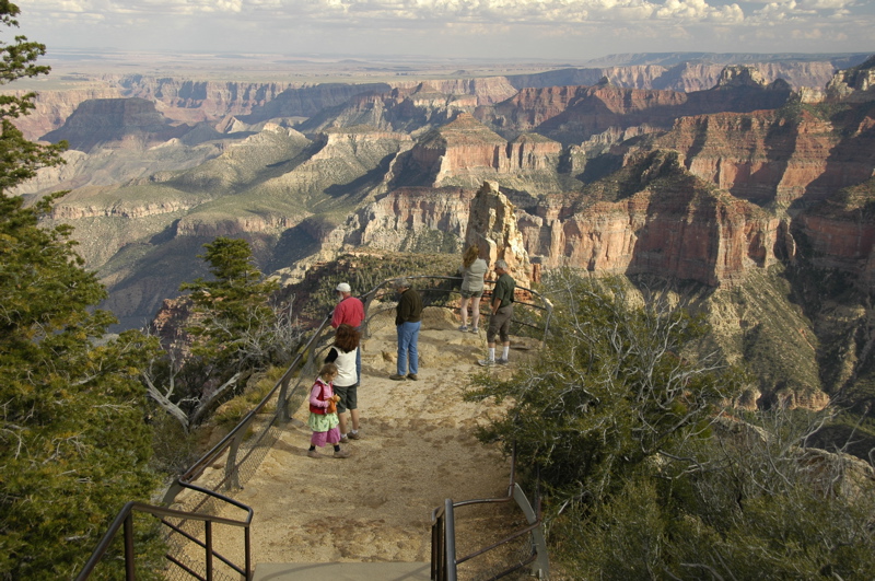
This part of the park has a couple of paved roads that wind out to fancifully-named points and overlooks: Cape Royal, Cape Final, Point Imperial, Vista Encantada, Walhalla Overlook, etc. To me, the names evoke the early days of the canyon’s development in the 1920s and 30s when Union Pacific’s subsidiaries were busy trying to make the canyon into a world-class tourist destination. Each overlook has its own distinct view, sometimes canyons, sometimes the Colorado River, sometimes the lower plateau of the Navajo nation to the east.
 Of course we dropped in on a ranger talk along the way. Emma got put to work, grinding blue Navajo corn the old-fashioned way.
 When we went by the Visitor Center in the late afternoon to get Emma’s Junior Ranger badge, we spotted a Grand Canyon Pendleton blanket hanging on the wall, and loved it. Ever since Fred Coldwell wrote an article about Pendleton’s national park blankets in the Spring 2007 issue of Airstream Life, I’ve been looking for one. So we bought it as a late anniversary present to each other (we had our 15th anniversary earlier this month). This one will keep us a bit warmer while at high elevation, but mostly I am looking forward to having it on our couch back at home base this winter.
Don and Daisy are work-camping here in the park, but mostly because they want to spend a lot of time on the north rim. With employment by the park’s concessionaire, they can stay six weeks or more in the employee campground with full hookups for a mere $5.50 per day. Usually they just volunteer; this is the first paying work-camping job they’ve accepted this season. With weekends off, they’ll have lots of time to explore before the north rim shuts down on October 15.
The north rim shuts down because of the heavy snows that blanket the Kaibab Plateau. The road coming into the park goes above 9000 feet, and keeping it open requires massive equipment. As far as I know, it has been closed each season since the lodge was built. The campground and lodge are about 8200 feet and I was told that last winter 14 feet of snow fell here.
Even now the chill is starting to creep in. The campground’s checkout time is 10 a.m., but at 6:30 the tenters are all up and pacing around, or making fires for breakfast. They start packing up early, and by 8 a.m. the campground is mostly empty. But still the campground fills every day, and it seems it will do that until sometime in October.
We have to leave today. No spaces are available to extend our stay, and I’ve got work to do on Monday anyway. Our plan is to drop into Page, AZ for a couple of days to get things done before heading into the Navajo Nation, and over to Canyon de Chelly.
Next entries »
 The Airstreams are housing for members of the park association as well as students who come here to get certified to fly light sport aircraft. Neil Bungard teaches these folks in Air Creation planes every morning and evening when the air is relatively calm and the temperatures are moderate. It takes about 28 hours of flight instruction to get certified, and so having the Airstreams as temporary housing is handy.
 We parked our Airstream in the gravel lot adjacent to the field for a night. There are no hookups and no formal transient spots for visiting RV’ers, but plenty of room to just dry camp. At night it’s very quiet, but in the morning and evening it’s nice to hear the sound of little aircraft engines practicing touch-and-goes on the runway. For a pilot, aircraft noise is a good thing.


