Archive for Places to go
September 20, 2008 at 12:09 pm · Filed under Places to go
On our first visit to the south rim of the Grand Canyon (last year) we restricted our hiking to the rim. Rim hikes are generally easy, without any real elevation gain or loss, and they are a great way to see the canyon with the perspective of altitude.
This time Eleanor wanted to hike into the canyon, at least a small distance. To hike to the bottom of the canyon, especially from the north rim, is a serious undertaking. The bottom of the canyon is at the Colorado River, 14 miles from the north rim. It’s not a day hike.
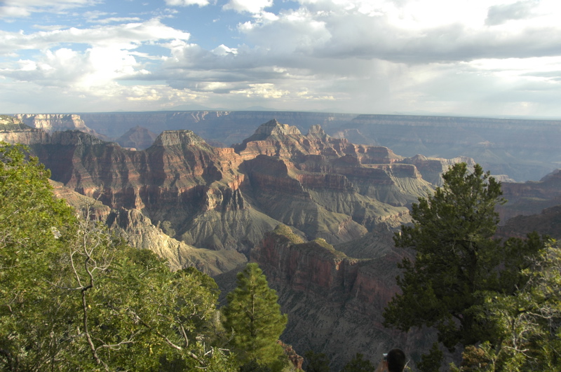
For day hikers like us, it is only possible to go a relatively short distance down. With a full day, we could have gone Roaring Springs, 4.7 miles one way and 3,000 feet below us. But we decided to check out Bright Angel Point first, a relatively easy hike from the Lodge about 0.5 miles roundtrip to a spectacular viewpoint. This would be our warm-up, and a chance to measure the canyon’s visibility (which turned out to be about 70 miles).
Bright Angel Point has short and steep ups and downs along its length. The total elevation gain/loss is not much, and the trail is entirely paved, but it seems hard. We encountered a lot of people struggling to make the uphill slopes. Even a short climb can be a challenge if you are out of shape, especially at Lodge elevation of 8,250 feet. It was a reminder that we were going to be facing a challenge on our next hike.
We chose the popular North Kaibab Trail, which runs from a trailhead on the north rim all the way to the south rim. It’s possible to do a rim-to-rim hike on this trail, with an overnight stop near the Colorado River or at Phantom Ranch, but you need to plan a year in advance to get the necessary backcountry camping permit or ranch reservation. The total trail distance is 24 miles to the south rim. We’re thinking about it for next fall. I heard that John McCain does it every year with his family. If he can do it, we can do it.
Our afternoon hike, however, was considerably less ambitious than rim-to-rim: 1.7 miles of steep downward trail, losing a total of 1,450 feet, a break at the Supai Tunnel and a refill of our water, then back up the same distance. By Grand Canyon standards this is a pretty straightforward trip, but don’t kid yourself about it. Rangers say to allow twice as much time to get back up as you took to go down, which is a reasonable guideline. Imagine taking the stairs from the top of the Sears Tower all the way to the ground, then going back up to the roof. Then imagine how you’d be breathing on those stairs if the basement were at 6,800 feet above sea level.
A total of 3.4 miles isn’t much for us normally, but the steep climb was psychologically challenging to Emma, and physically challenging to Eleanor’s asthma. On the way down, we met a pair of rangers who were concerned about Emma overheating on the climb back up. Kids often do that, because they are smaller, don’t manage their energy well (sprinting ahead), don’t remember to drink water, and prefer to eat the wrong type of snacks.
I was concerned as well, but we had prepared for this. Last week in Kanab we bought Emma a 1.5 liter Camelbak hydration reservoir and hooked it up to the purple backpack that her stuffed cat Zoe always rides in. That made it easy for her to drink steadily through the hike. At the rest stops we plied her with a mix of snacks designed to keep her energized and keep her electrolytes where they should be.
How your body feels has a lot to do with what you think you can do. But even with experience on many other hikes, and appropriate food and water, she faced the tough challenge of breaking through the mental barrier of “I can’t do this!”
This is always the low point of any tough hike we do. “I can’t!” is a kid’s way of expressing a more complex set of thoughts: I’m tired, I’m thirsty, I’m regretting that I got into this, I don’t know what’s going to happen, I’m afraid of failing, I’m afraid of getting hurt, I don’t know what I’m supposed to do, etc. We’ve been here many times before, and I suppose most parents have been. Whether it’s learning to ride a bike, do a math problem, or tackling a steep hill, it is never easy to get past the “I can’t!” barrier.
I think a lot of people choose to avoid this awful moment, standing somewhere in public, trying to negotiate the murky world of a child’s psyche while other people wander by with their opinions etched on their faces, and the clock ticks against some pressing deadline like sunset. So they try to avoid situations like this. We decided early on that the challenge was worth the results, and so far it has been. I won’t say it has always been fun, but in the end we always get where we are going, and Emma always comes out of it feeling better about herself than she went in. Experience is a great teacher.
By the second half of the climb Emma was feeling fine and even leading the parade, and my thoughts then went to Eleanor, who certainly never would have done something like this fifteen years ago, and still probably shouldn’t do something like this in the humidity of the east. She has also conquered some of her fears, and learned to manage her asthma to the point that she can hike uphill 1,450 feet in 1.7 miles and do it in a very respectable time.
Coming out of the canyon on any hike, you can’t help but be awed by the vastness of it. We are merely ants in this massive place, and our efforts are puny when pitted against the environment of the canyon. The canyon can swallow us in a few hours. It is only through cooperative effort and modern technology that so many people manage to survive it.
It isn’t the deepest, the widest, nor the longest canyon in the world, but it is indisputably the grandest. I think the fact of its grandeur makes us want to be part of it, because by joining the canyon you are forced to see yourself as you are: an individual speck in something much larger. The introspection that comes from hiking the canyon is good for your perspective and for your self-confidence. I think we have all benefited from that.
Another thing I can tell from our past couple of days’ experience: three nights is not nearly enough. If we could get a campground opening for Sunday night I would definitely take it. Or, if we had some friends in the area who could go with us, I would go back up to Kanab, park the Airstream, and take the 61-mile dirt road down to Toroweap (also known as Tuweep) and tent camp on a different section of the north rim for a couple of nights. One of the outcomes of our last month traveling through southern Colorado, Utah, and northern Arizona is that we have a long list of places we want to come back and explore further. The best thing we can do is make notes and look forward to next year’s trip.
September 19, 2008 at 12:29 pm · Filed under Places to go
For some reason people often thing that the Grand Canyon is in Utah, or that it is divided by the states so that the north rim of the canyon is in Utah. This may stem from the fact that most of the other major southwest parks are in Utah (Zion, Bryce Canyon, Capitol Reef, Canyonlands, Arches, etc), but in fact the entire Grand Canyon sits firmly in Arizona, our adopted home state.
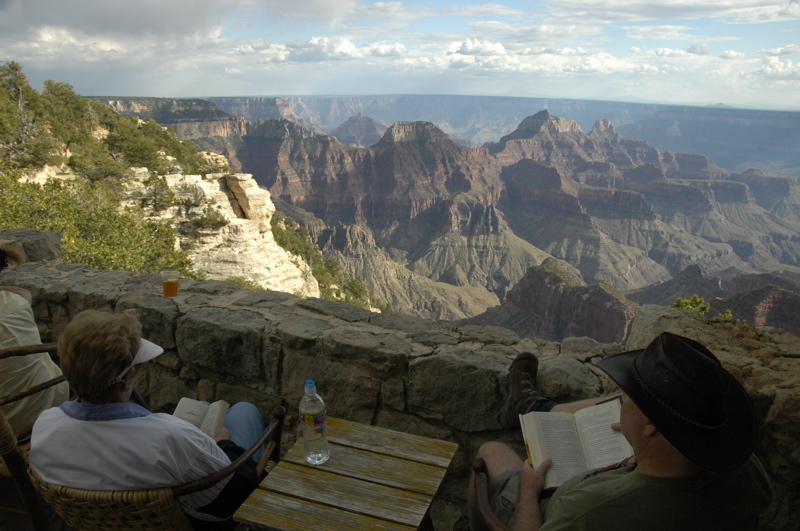
In western terms it’s not a long drive from Kanab, UT down to the north rim ““ about two hours, versus three days in the horse-and-buggy era before the road was put in. But to get here is still a challenge for people, and so the north rim sees much less visitation than the south rim. People come here for the calmer, less crowded atmosphere, where you can sit and enjoy the views for hours without sitting in the midst of a mob.
Here’s a quick comparison of North versus South rims:
North Rim:
Much less crowded; good opportunities for solitude
Less development (hotels, shopping, restaurants). One lodge.
More 4WD roads
Higher elevation (about 8,200 feet at the lodge)
Colder (closed after Oct 15)
Closer to other major parks
South Rim:
Has a train station with daily service
Fantastic Mary Elizabeth Coulter architecture everywhere
Tram/shuttle service to popular areas
Lower elevation/ warmer than north rim
Better views of Colorado River
Far better chance of spotting condors
More Ranger programs and talks
More hotels and development
Closer to population centers (Las Vegas, Flagstaff) and I-40
Both sides of the canyon have great hiking, mule rides into the canyon, inspirational views, etc., so you can’t go far wrong visiting either rim. No need to get into over-analysis; just pick one and have fun.
 Some people can’t decide and so they try both rims. On the drive up the Kaibab Plateau yesterday, we stopped for a stunning view of the Vermillion Cliffs. We met a couple of guys heading up to the north rim as well, and they said, “We’ll see you there!” I asked if they were camping or staying in the lodge, and they replied, “No, we’re going on, to the south rim today.” Their plan was to drive to each rim and “see” them both in one day!
That’s a trip best suited to a helicopter. Even though it’s only about ten miles from rim to rim (if you could fly like the California Condors that live here), the drive from rim to rim is over 200 miles. Imagine trying to see both Boston and New York in one day. They haven’t yet put a bridge over the Grand Canyon and let’s hope nobody ever does.
Since we’ve been here only one day, I’m withholding judgment on which portion of the canyon I like best. We’ve got three nights booked and it seems barely enough. We may have to come for a third visit next year and hike down to the bottom of the canyon before a decision can be made. In fact, I want to come a fourth time and drive the 61-mile primitive dirt road down to Toroweep (another portion of the north rim) and tent-camp a few days there, too. The Grand Canyon is an enormous place and in years of visiting I’m sure we will never experience even half of it.
 We’ve met up with friends here. Daisy Welch, who writes occasionally for Airstream Life magazine both in print and online, left a note on our windshield when we were parked at Bryce Canyon last week. She spotted our Airstream parked in the shuttle lot on our last day (it’s not hard to identify with all the stickers on it). I emailed her the next day and found out she was heading to Grand Canyon north rim to work for a few weeks in the park.
So when we arrived yesterday, I found her in the post office at the lodge, and her traveling companion Don working at the lodge’s main desk. We haven’t seen Daisy in three years, but she looks great and seems to be having a wonderful life work-camping with Don from place to place. Their day off is Saturday, so we’ll spend part of the day with them, exploring some of the park together.
Campground report: The North Rim campground is very popular. Reservations are mandatory most of the season. There’s no overflow camping. All of the sites are shady, in a tall Ponderosa pine forest, and few are level. There are no hookups. From the campground it’s an easy 1.2 mile (each way) hike along the Transept Trail to the Lodge with spectacular views along the way.
The campground is very convenient with a good general store, free wifi at the store, bathrooms, dish washing sinks, dump station, etc. There are nightly amphitheater programs. We attended two afternoon programs at the Lodge (condors and geology), and the evening campground amphitheater talk as well.
 There is apparently a cell tower around here. All around the Lodge I saw people chatting on cell phones. There’s a weak signal reachable from the campground too, but I’ve left my phone off. I told everyone I’d be unavailable through Sunday, and I see no reason to change that just because somebody decided to put up a cell tower. The Lodge is a nice place to just hang out and enjoy the view from one of the big comfy leather chairs (or study for your Junior Range program). The wifi at the general store lets me receive email but they’ve got outgoing email blocked for some reason. I can work around that if I need to, by using web-based email instead.
It’s definitely cooler up here, but not bad right now. We’re getting days in the upper 60s, nights in the mid-40s. It’s hard to believe this place closes down in four weeks, but we’re told that the winter snowfall is immense. At night we hardly need heat, so we ran the catalytic heater for a few hours in the evening and then shut it off for the rest of the night. When I woke up this morning the trailer was at 58 degrees.
Solar report: Because of the tree canopy we aren’t getting much solar power. At about 9 a.m. we were getting only 0.5 amps, which is essentially nothing. In the afternoon our rear-mounted panel gets full sun for a couple of hours, but that won’t be enough to replace the power we use, so for our visit here we are essentially running on batteries. From time to time I hear someone running a generator.
Today’s plan is simply to explore and enjoy. What else would you do here?
September 15, 2008 at 4:27 pm · Filed under Places to go
Acting on a tip from a blog reader, we drove over to Pipe Spring National Monument in nearby Fredonia AZ. It’s only about 25 miles from Kanab, but with all the BIG national monuments and parks around, we might easily have overlooked it.
 The site is located in the middle of a small reservation belonging to the Kaibab band of the southern Paiutes. It jointly celebrates the life of early Mormon settlers and the native Americans who lived on this land for untold years before. The outside displays include structures built by the Mormons, and inside the museum are interpretive displays about the Paiutes and their gentle, earth-friendly philosphy.
The Paiutes believed that “all things are placed on this land with the breath of life, just as humans,” in the words of a tribal elder. “This land is considered to be their home, just as it is for man, and it is taught that one must consider that rocks, trees, animals, mountains, and all other things are on the same level as man. Each has a purpose in life, and the one who created every living thing on this earth placed all living things here to interact with one another … It is said that the plants, animals, and in fact, everything on this land, understands the Paiute language, and when one listens closely and intently enough, there is affirmation and a sense of understanding.”
 The philosophy of the European settlers was quite different. They set out to tame the land, populate it with large families, and convert the natives from “aimless wanderers” to farmers. They were not successful with the natives, who were already struggling with loss of traditional lands and encroachment, and wanted to retain their heritage. But the Mormons did successfully set up a “tithing ranch” which used a barter system for mutual benefit of their community, and the remains of this ranch are the centerpiece of Pipe Springs National Monument.
 Being a small park with a lot of dedicated staff and volunteers, the interpretation was excellent. Three of them spent quite a lot of time with us, answering questions and giving demonstrations. One ranger gave me a ton of tips on vegetable gardening in the southwest desert, which will be useful for Tucson once we settle in there. The park maintains orchards and vegetable gardens full of heirloom plants, and they share the produce freely with anyone who visits. I collected a package of beans and other seeds — we’d like to try growing some of the traditional crops in our garden too.
I’ve discovered that Kanab, UT (our present location) is an excellent base of operations to visit the national parks. Bryce Canyon NP is about 85 miles north, Zion NP is 60 miles west, and Grand Canyon’s north rim is about 75 miles south. Pipe Spring NM is 25 miles southeast, too. We’re sitting just a few miles north of the Arizona border (Karen) with all the conveniences of a small town, with wifi everywhere, inexpensive full-hookup camping, and nice views of the red rock mesas.
They call Kanab “Utah’s little Hollywood” because of all the westerns that have been shot here. Downtown there are plaques commemorating the movie stars who came here and in some cases lived here part-time. There’s not much settlement around Kanab, so there’s plenty of scenery to be had, and Kanab is happy to supply the rest. It makes a decent spot to hang out for a while between adventures, or a good spot to come back to after a day of ATV riding or hiking out in the country.
Grand Canyon’s north rim is less visited than the south, but there are also fewer camping choices near the rim, so you still need reservations. Our reservation is for Thursday, which means we’ll be parked in Kanab for a while. We are considering a day trip into Zion beforehand, but really, I should keep at the computer most of the time we are here. Most likely we’ll just stay and enjoy the fine late-summer weather (80s and sunshine every day).
September 11, 2008 at 11:19 am · Filed under Places to go
When met Rick on the road at Escalante a couple of days ago, he told us he was coming out of Bryce Canyon and heading for Capitol Reef. We exchanged tips about the respective parks, but his warnings about Bryce were not very encouraging. It was crowded, he said, and solitude on the trails was going to be hard to find.
 He wasn’t exaggerating. For whatever reason, Bryce has been chosen by far more people that the other Utah parks we’ve visited, in fact, one million visitors per year. Now, Bryce is a very nice park, but I can’t quite see that it is twice as good as Capitol Reef or Mesa Verde (each of which get about half a million visitors per year), or three times as good as Big Bend. I suspect the volume of visitors has to do with the fact that it is close to Grand Canyon and Zion, and because you can see the best views from your car without any hiking effort.
The tour buses are here in vast fleets, segregated by foreign country. Standing at the overlooks I could tell which bus had arrived by a sudden wave of people speaking a different language. There were Japanese, Italian, German, and Scandinavian waves, and as tour groups tend to do, they would all go to the same place at the same time. This caused logjams here and there, but Bryce has been engineered to handle the crowds, like Disneyland. There are bus depots at the major stops, special bus parking areas, and traffic patterns. A shuttle service operates in the park and reduces individual car traffic & parking problem, too. Still, I wonder if in a few years cars may be prohibited from parts of the park as is currently done in Zion.
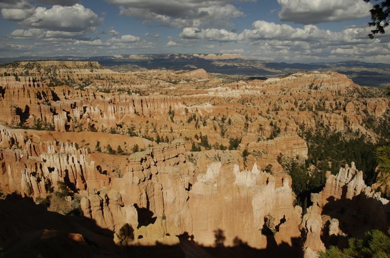
In Zion, you are in the bottom of the canyon looking (and hiking) up. In Bryce, you are on a narrow ridge that defines one edge of a valley, and all the hikes go down. It’s more like Grand Canyon in that respect, but the valley (they call it a canyon) is not as well defined on the opposite side. The best viewing is in sunny conditions, especially as the sun is rising or setting.
 One popular ranger-led activity is pictured at right. Care to guess what it is?
Tree-sniffing! The bark of the Ponderosa Pines sometimes has a distinct odor like butterscotch, if you’re willing to press your nose to one and take a big sniff. Being able to watch this is one of the upsides of having crowds in the park.
Part of the reason the park is still so busy is that the season is very short. The park had its last snow in mid-June, and temperatures began to go below freezing at night in mid-August. Days are warm right now, but storms are frequent and the lightning is really dangerous. People stand out on the exposed ridges and get zapped at the rate of about one person every other year. We got chased off Rainbow Point by an approaching line of showers and high winds while we were observing a 1,600 year-old Bristlecone Pine tree. With the constantly-changing weather (and a bit of laziness), we were only able to hike about three miles all day.
 After two nights, we are being forced out by an incoming tour. The campground we are staying in can’t accommodate us any longer, and the national park campgrounds are still very full. Weighing the options, we’ve decided to leave Bryce Canyon and head south to Kanab for a few days. We are booked into the North Rim of the Grand Canyon starting on Wednesday, so we have a few days to get ahead on work, and make some side trips. But since it is only about 80 miles to Kanab, we will take advantage of Bryce’s shuttle system to have one last hike. We’ll park the Airstream in the large shuttle parking lot, hike the Queen’s Garden/Mojave trail (2.9 miles), and then proceed south to Kanab.
 Also, we have confirmed that we will be going to the Albuquerque Balloon Festival Oct 3-6. This is a major detour east, but it will allow us to visit several other national park sites and explore some of so-called “Indian Country” (mostly the Navajo reservation but also passing by the Hopi, Zuni and several other tribal territories). See approximate trip plan at right — click to enlarge. We’ll go past Monument Valley, spend a few nights in Gallup, drop by some national monuments in New Mexico, and then go check out a few sights in southern New Mexico before heading to Tucson. At this rate, we’ll be back to winter home base in mid-October, just in time for the nice weather down there.
September 8, 2008 at 3:14 pm · Filed under Places to avoid, Places to go, Travel / lifestyle musings
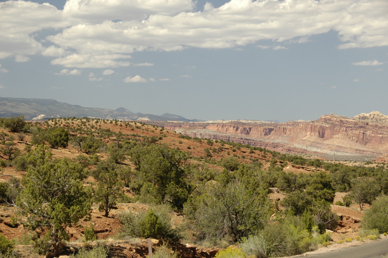
In my rush to post a quick blog entry yesterday I didn’t have time to describe the setting of Capitol Reef. The park is 100-mile long north-south sliver of Utah, surrounding an ancient fold in the Earth’s crust where tectonic plates collided, forced a ridge to the surface, and then weathered into remarkable canyons.
They call this the “Waterpocket Fold” because the geography traps pockets of water which encourage plants and animals in this part of the Utah desert. Indeed, in the center of the Waterpocket Fold are the remains of the historic town of Fruita, where Mormon settlers lived from the 19th century until 1969 and raised fruit trees. The park is centered in Fruita, and the National Park Service still operates the orchards for visitors to pick fruit seasonally.
Fruita is really a series of strips of lush cultivated land inside the canyons, flattened out and manicured into parklike settings. After driving through a hundred miles of red rock desert, it is startling to arrive in Fruita, where green grass and shade trees are everywhere, and a creek flows rapidly alongside the campground. It is like arriving at a city park, an oasis in the midst of dry sandstone and crystal clear blue skies.
The skies are part of the reason the night stars and daytime views have been so startling. The average summer day visibility here is 145 miles! Very little pollution from southern California, Las Vegas, or southern Arizona arrives here ““ so far ““ and there’s not as much airborne dust, pollen, or humidity as other places. The result is magnificent views day or night. Yesterday we could easily see mountains a hundred miles away, from Panorama Point.
In the campground our view is quite different. We are sitting in a canyon looking up at sheer rock walls on both sides. The sun reaches our solar panels more than two hours after it has lit the high peaks of the canyon walls, and we are in shade about two hours before actual sunset. (Fortunately, we are still getting enough solar power to keep up with our daily usage.) From the bedroom’s front window we get a marvelous view of the glowing red sandstone in the light of the setting sun each evening.
The danger of visiting so many incredible western parks in such a short time is that you can begin to lose appreciation for them. It’s easy to say, “Ah, that’s just another pre-historic petroglyph,” or think, “I already hiked a canyon, so let’s skip that.” On a daily basis we are seeing things and hiking places so wonderful that any one of them would be the highlight of a week’s vacation. Too much of that is like eating too much dessert, and we don’t want to get sick of this only halfway through our planned loop of Utah.
We also are spending a lot of time studying the history of the area (Butch Cassidy, Mormon settlers, the “Fremont people,” early European explorers, geologic history, etc.) I have been reading a book about Utah’s outlaws every day, in addition to guidebooks, maps, and interpretive signs everywhere we go. Emma has been working on Junior Ranger projects continuously for over a week, and she needs a break from that too. Even though we are having fun, we are constantly learning about where we are, and eventually that can be a burden too.
So once again our trip plan is changing. (It will keep doing that.) Rather than rush down to Bryce Canyon today, we are spending another day, and possibly delaying our arrival in Bryce. Everyone is telling us that the Rt 12 route from Torrey to Boulder and Escalante is one of the most stunningly beautiful drives in the country. We were originally planning to cover the 118 miles from here to Bryce Canyon in an afternoon, but now I’m thinking we might take most of the day just to get to Escalante, or spend the night at Calf Creek (BLM) for a night. That will allow plenty of time to stop and take pictures along the way, or visit roadside attractions like historic sites.
For today, our plan is very low-key. I’ve been working on the magazine since 7 a.m., and will probably spend the rest of the morning at that. Eleanor and Emma will go explore some of the historic structures of Fruita, and then around noon we’ll go to Torrey to pick up our mail and send/receive email at Robber’s Roost (a local bookstore/café). We might drive another dirt road down a canyon just to see what’s there, but we won’t do any hikes.
In other words, today is a day “off” from the schedule of hiking and studying. It’s funny how a day of business and errands can be a welcome relief from physical recreation. Emma has announced that on her day off she is planning to spend the entire day in bed reading. I think we’re all looking forward to a day like that.
Late note: We found Robber’s Roost to be a very comfortable cafe (and smallish bookstore), but the free wifi didn’t work. There was a connection error when I tried to join the network with my Mac. We asked permission from the on-duty manager to unplug one of their computers and use the that computer’s Ethernet cable to connect to the network. He said it would be no problem. Later, when I was outside on the phone, the Uber-Manager showed up and bitched Eleanor out for connecting to the Ethernet. “I charge for that, you know!” Turns out she knew the wifi was misconfigured so that only PCs can connect to it (not Macs, for some reason), but rather than fix it she chose to blame the Macs instead. The on-duty manager was embarrassed. I could have fixed their wireless router but didn’t even bother to suggest it. The “high speed Internet” connection turned out to be dial-up, too. Go for the coffee, but don’t bother going for the Internet. Go to the burger shop instead.
Second late note: There are few services near Capitol Reef Nat’l Park. Gas is available in Torrey (11 miles from the visitor center), but not much else. Verizon and Sprint have no service here. (We made a few calls “roaming” on some local network, but I’d be careful about that if you don’t have a roaming plan as Eleanor’s phone does.) There is one ATM that we know of, but it didn’t work. The town shuts down even more in the winter season, which I think means all the art galleries close. Come here with everything you might need.
September 5, 2008 at 5:01 pm · Filed under Places to go
It’s both a privilege and a challenge to be “professional campers.” We travel for fun, sure, but in this blog I have tried not to gloss over the many things that go wrong, and the difficulty of balancing the work and play. Today was a typical example of how we usually get a little bit of both.
 We took a look forward in the calendar and decided that it was time to leave Hovenweep after only two nights. We’d seen 80% of the publicly-accessible ancient Puebloan ruins, hiked most of the trails, and Emma had completed her Junior Ranger program. But also we saw time beginning to run short on us. We’d like to complete our loop of Utah national parks before the end of the month.
One reason to wrap up this month is that we are considering going to the Albuquerque Balloon Festival, October 4-12. We had reservations for last year, but abandoned them when we decided to go to Banff and the Pacific Northwest instead. This may be our last chance to go, if we find ourselves bound by school schedules in the years to come.
Another reason is weather. Right now it is ideal weather at the upper elevations, but in October things will get distinctly fall-like. The mid-70 to mid-80 degree days we’ve been having are ideal, and the nights have been warm enough that we have only needed heat on a few occasions.
So we drove out of Hovenweep this morning, zig-zagging along county roads to eventually find ourselves at Natural Bridges National Monument about 75 miles drive to the northwest. The Hovenweep area is a bit of a Bermuda triangle for GPS units. Garminita very much wanted us to take some dirt trails across the desert, which would have been fun had we not been towing the trailer. We had to disregard the GPS for about fifteen miles and use the old reliable paper map instead.
Not long after we settled our differences with Garminita, the trailer brakes stopped working. It was the usual scenario, one I’ve started to become rather comfortable with since it has now happened three times. All was well, and then when coming to a T-intersection I noticed that I suddenly wasn’t getting the brake response I expected. I pulled the manual override on the Prodigy brake controller and sure enough, no trailer brakes.
Once again the problem was a dirty ground wire on the trailer. We had last cleaned the wire in May, in the Florida panhandle, but I suppose two weeks of salt air at the Outer Banks of North Carolina and two months of intense humidity in Vermont had their effect. This time we really scrubbed both the ground wire and all the points it contacts, first with a screwdriver tip to scrape off some accumulated varnish, then copper wool, then Emery cloth (fine sandpaper). Problem solved in about five minutes.
I can only plead distraction for the next mistake. Fuel is exceptionally rare out here, and literally our only shot at it was in the town of Blanding. I mistakenly listened to Garminita and took the turn onto Rt 95 toward Natural Bridges, forgetting that we needed to overshoot the turn and go into Blanding for fuel. By the time I remembered, we had passed through two canyons with 8% grades and were about seven miles away.
At that point we had a half tank, but that means nothing out here. I had a choice of working back to Blanding (easily a 20 minute drive each way, with those darned canyons), or proceeding north toward Natural Bridges and hoping for fuel in that direction. Garminita was no help: her database of fuel stations is woefully incomplete. She claimed there was no fuel for at least 90 miles going north.
I decided to proceed to Natural Bridges (25 miles further) and make inquiries there. If there really was no fuel heading north, I’d unhitch the trailer in the campground and return to Blanding alone for a refuel while E&E did something else. But fortunately the rangers reported an automated fuel station in the settlement of Hite, about 50 miles further up the road. We have plenty of fuel to get to Hite.
I have to remember the “Rule of Fuel” here: Always stop for a refill whenever you can, regardless of price. There are no major towns in this part of Utah. A 28-gallon tank such as the Armada has, is sufficient to tow through this area if it’s kept more than half full. Seventy miles between gas stations is not unusual. Years ago, when we towed our Caravel with a Honda Pilot, I quickly discovered that a 19 gallon fuel tank is a joke when towing, even in the east.
With the fuel worry lessened, we faced another challenge. The campground at Natural Bridges is only 13 sites and they are all quite small. It’s really best for tents and very short motorhomes. Signs say that maximum allowable length is 26 feet combined. When I told the rangers we were towing a 30 foot trailer, they kind of grimaced but didn’t say anything. I told them we were accustomed to squeezing into tight spots. (We are, after all, professionals.)
Well, we are, but I have to admit that this is one of the tightest campgrounds we’ve camped in. Our combined length is about 52 feet ““ double the suggested limit ““ and that meant careful navigation through the loops leading to site #9, where we backed in and then parked the Armada alongside. This is probably the hardest campground for us to fit into since Jedediah Smith Redwoods State Park in northern California.
I wouldn’t recommend trying this without a lot of prior experience. The alternative campground is seven miles away on a free BLM site, so if you come to Natural Bridges and are oversized, stay there instead. Also, the Natural Bridges campground does not take reservations and it is so small that it fills up quickly.
The big challenge of camping in this region is managing our resources. Other than in the town of Blanding, there are no campgrounds, no dump stations, and very little water. Hovenweep had sulphur-tasting water but nothing else. Natural Bridges’ campground doesn’t even have water (and again, no dump station). Water is obtainable at the Visitor Center, and a sign there says the limit is five gallons per day. We picked up three gallons today. Two and a half gallons went into the water tank and the rest was set aside for cooking.
So we have been watching our water consumption extremely carefully. We won’t get a chance to dump the tanks until we get to Capitol Reef (or the nearby town of Torrey). Hiking in the sun, with lots of sunscreen on, demands a shower at the end of the day, which makes the water-management job much harder.
The only resource which hasn’t been a challenge is electric power. In between hikes I’ve been writing up notes and editing articles for the Winter issue of the magazine on the laptop, and Eleanor has been using her laptop as well. Our solar panels have kept us well supplied. At this writing our batteries are 94% full, and our last plug-in was Tuesday morning. I love the desert sun.
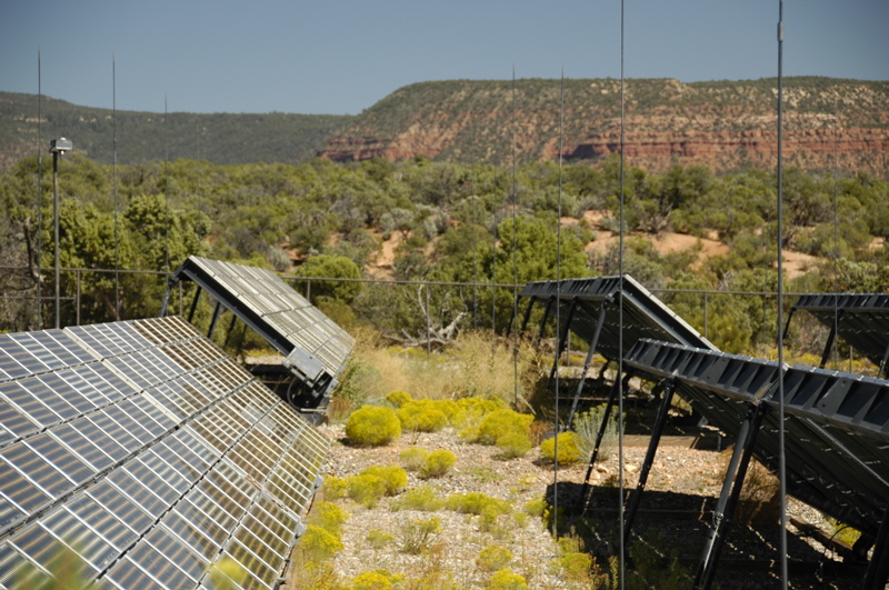
In fact, the sun is so abundant here that Natural Bridges was chosen as a demonstration site for solar power. The Visitor Center is powered by the sun, using two arrays of panels across the street. A short trail leads down to the 50,000 watt solar arrays, encouraging visitors to see.
 The big draw, of course, is the three natural bridges formed in the canyon below by water erosion. Each one has an overlook point from the 9-mile loop road, so you can see them all without hiking, and each has a hike down into the canyon to get a closer view.
 We did two bridge hikes and one other hike to see another set of cliff dwellings, totaling only about 1.5 miles. Emma has a sore ankle from a minor twist a few days ago, and we’re trying to give her a break. We won’t do any hiking tomorrow unless she’s entirely recovered.
Tonight there is an evening program involving a telescope. This area has some of the darkest night skies to be found in the United States, and the skies have been crystal clear each night since we got to Hovenweep. There, we stood outside the trailer at night and looked up to the most brilliant display of stars I have ever seen. The Milky Way was a unbelievable flood of stars, and Jupiter was glowing like a streetlamp. So if we can manage to stay awake until 9 p.m. tonight, the evening program should be pretty good.
That pretty much covers what this little park has to offer, so tomorrow, after picking up Emma’s Junior Ranger badge, we’ll move on to Capitol Reef.
September 4, 2008 at 6:40 pm · Filed under FAQs, Places to go
I have to remind myself that not everyone knows the location of Hovenweep National Monument. It is one fairly small US National Park site of about 390 in the western hemisphere, and it’s hard to get to. You really have to want to come here, because it’s just not on the way to anything.
 Hovenweep National Monument is actually a series of small parcels of land scattered across the southeast corner of Utah and the southwest corner of Colorado. It’s a bit confusing to people, I think, for several reasons. First off, a lot of people think that only places with “National Park” in their name are actually national parks. Actually, the National Park Service system includes National Monuments (NM), Nat’l Historic Sites (NHS), Nat’l Recreation Areas (NRA), Nat’l Memorials (N MEM), National Seashores (NS), Nat’l Historic Parks (NHP), Nat’l Battlefields (NB), Nat’l Scenic Trails (NST), and a few oddballs like the John D Rockefeller Jr Memorial Parkway (near Grand Tetons). All told, there are about 390 sites in the United States, plus a few in US protectorates like Guam, Samoa, Virgin Islands, and Puerto Rico. The number keeps rising as new parks are being authorized all the time.
To make things more confusing, this national monument is surrounded by another national monument: the recently-formed Canyon of The Ancients Nat’l Mon. So as you are driving from one “unit” of Hovenweep NM, you are also in and out of Canyon of the Ancients.
But wait, there’s more. Some national monuments are not in the Park Service system, but instead are administered by the Bureau of Land Management (BLM). Easterners are often not familiar with BLM, but out here in the west BLM owns vast tracts of land, which is often open to recreation, mining, and drilling. BLM Nat’l Monuments often are just open space with a few primitive 4WD roads and no developed facilities (such as a Visitor Center or campground). Sonoran Desert Nat’l Mon in Arizona is one example, and so is Canyon of the Ancients.
 At Hovenweep, the Visitor Center and campground are in the “Square Tower Unit” of the park, located in Utah. Today we drove northeast to three other units where more ancient Puebloan ruins can be seen. The Horseshoe & Hackberry Unit, Holly Unit, and Cutthroat Castle Unit are all located just 4-9 miles away, but they are in Colorado, and they are within Canyon of the Ancients Nat’l Monument.
This results in an interesting study of how the two government agencies administer their land. The Hovenweep units are fenced, have better signage, pit toilets at every trail head, and are more closely monitored. Camping is prohibited except at the campground we’re in. There’s also a day-use fee to access any part of Hovenweep. The rest of the land is BLM, and the rules are less clear (and possibly less restrictive). There’s no fee or services in the BLM’s Canyon of Ancients Nat’l Monument.
Visiting all five units of Hovenweep will certainly be a very full day, or even two days. We have visited four so far, and hiked most of the trails. To visit the other ruin sites you need only a car (you can hike right from the campground but it adds 8 miles roundtrip to the day), assuming the roads are dry. If wet, the guides say they “may be impassable.”
The only site that can’t be reached by car is Cutthroat Castle. You can get most of the way in with a car and then hike down to the sites, or if you have a high-clearance 4WD vehicle like us, you can have an interesting drive down and hike just 0.1 miles to the site. After doing three other hikes, we chose the interesting drive. 4WD Low Range all the way and it was great fun.
 Because of the BLM/NP borders, it happens that the exceptional “Painted Hand” pueblo ruin is also on the same access road as Cutthroat Castle. Because it is on BLM property (and thus part of Canyon of the Ancients NM), the brochure you get at the Hovenweep Visitor Center doesn’t even mention it, and it’s not depicted on any of their maps. But it’s right there, almost impossible to miss as you head to Cutthroat, and you must visit it. Painted Hand has towers, kiva depressions, pictographs, farming terraces, and great views. Best of all the round-trip hike is less than a mile. I’m glad we visited Mesa Verde first, so we knew what we were seeing.
We’re still alone here. We did see one other couple visiting some of the ruins today, but other than that it has seemed as though this is our own private national park. We could really stay another night, but we’re juggling our desire to visit Capitol Reef and other places as well. One limiting factor of this park is that it has no dump station, and because of the remote location they ask that we take all our trash with us as well. With careful conservation, those factors won’t force us out for a few days, so the choice is ours to make.
« Previous entries ·
Next entries »


