Archive for Roadtrips
May 21, 2008 at 5:30 pm · Filed under Roadtrips
Our next scheduled appointment is the Tuesday after Memorial Day, at Colonial Airstream in New Jersey. The plan is to stop there for a few days to get some service done, so if anyone wants to drop by, send me a note. Otherwise, I’ll have to fill the days by working at the computer, which is to be avoided at all costs.
In the meantime we have a week to get to Lakewood NJ and no particular obligations until then. We could have extended our visit to the Outer Banks but the mosquitoes were getting aggressive. Emma had a small reaction to insect bites and one of her feet swelled, along with a spot on her arm. So we spent some time in the morning to say goodbye to our friends the Hallingers, and they gave us some strawberries as a parting gift. Then we started towing north with no set destination.
 When we have extra time, we slow down and try to travel no more than 150 miles on travel days. This is mostly a strategy to allow us to see more than just roadways, but it also serves to spread out the cost of travel, which is especially important lately.
This meant we just got across the Chesapeake Bay Bridge-Tunnel and then picked a place to stop, the tongue-twisting Kiptopeke State Park.

The Bridge-Tunnel is an amazing thing, and even having crossed it two or three times, I am still fascinated with it. Stopping on the man-made islands and watching giant freighters float serenely over the submerged tunnel spurs my imagination. It seems impossible that the tunnel can exist with all that water and hundreds of tons of steel ship atop it. Then I think about the nuclear submarines that ply these waters, perhaps traveling by as I watch, but unseen by eye or satellite. And then we drive through the tunnel …
Just three miles south of Kiptopeke is the Eastern Shore National Wildlife Refuge. The visitor center for this refuge is well worth a stop next time you are cruising up or down Rt 13 on the eastern shore. Not only is it a top-notch visitor center with excellent exhibits, but it features a very cool indoor bird-watching room with binoculars and spotting scopes supplied. There’s even a live TV feed from the nest of a pair of ospreys with two chicks, which was fascinating. I’ve never seen such a good NWR visitor center before, and hardly anyone was there when we visited.
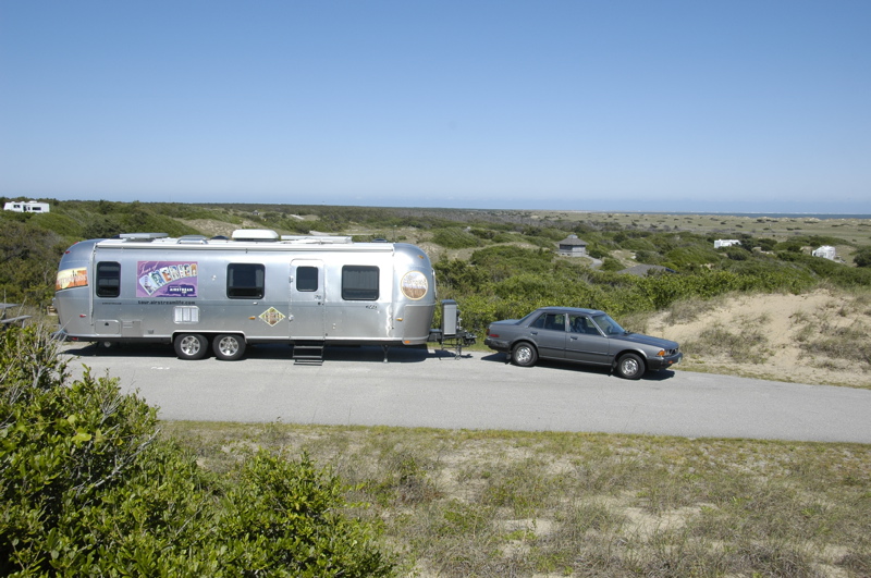
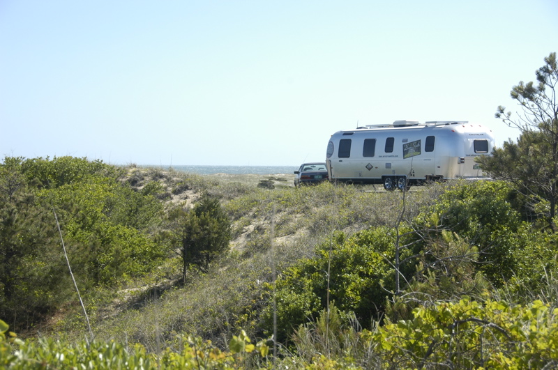
Setting up here at Kiptopeke, I was struck by two things. First, the park has the appearance of once having been a private campground. Every site has full hookup, but you have the choice of using the sewer connection or not. If you use the sewer, it’s $5 extra. Every site also has cable TV, which is unheard-of in most state parks. Whoa, the luxury. After ten days of zero hookups (eight in the Outer Banks and two nights prior), it’s a real adjustment. But then, it’s $31.50 per night.
Second, there’s no wind today. This is the first time in nine days that we haven’t had a stiff breeze. I can open the dinette window again (the glass could not be opened earlier because the wind kept it pressed tightly against the frame). I could put out the awning if I wanted. I can even have a conversation on the telephone outside. The wind was invigorating and at times, even thrilling, but there’s something to be said for a calm day too.
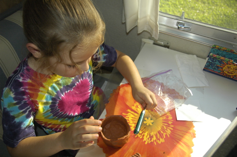
Emma works on a clay “pinch pot” project
Tonight we will feast, because Eleanor wants to make room in the freezer for tomorrow’s stop at The Great Machipongo Clam Shack. Ribs, cornbread, and strawberry pie. It seems like summer is here at last.
Our coordinates: 37 °10’32.30″N 75 °59’2.24″W
May 13, 2008 at 4:46 pm · Filed under Roadtrips
We set the alarm for 6 a.m. so we’d be ready to get on the 7:00 a.m. ferry if it were running. I was thinking this was a waste of a perfectly good opportunity to sleep in, since the forecast was for continued strong winds all day, but for whatever reason we did it anyway.
At 6 a.m. the alarm rang, and I gave serious consideration to the idea of getting up, but decided the bed was too warm and the trailer was too cold. (It dropped into the mid-50s last night and we have not been using the furnace.) Eleanor got up and dressed, apparently feeling industrious, and she went out to the toll booth to have a talk with the ticket-seller.
 The 7 a.m. ferry did leave, but we stayed to consider our options. I didn’t want a wild ride on the waves even if the ferry captain was willing to go. The waves looked every bit as menacing as they did the day before, and the wind was scarcely less. Officially, the forecast was for 20-25 knot winds and seas 2-3 feet, but that seemed optimistic. The ferry is scheduled to take 2.25 hours, which is a long time to be holding onto one’s stomach.
Finally we decided to take a chance and go, so we shoehorned the Airstream onto the ferry. That was an interesting process in itself, since I don’t have much faith in strangers who want to guide me forward or backward. I was busily watching in all directions as we crept on board and into the narrow lane, but the crew didn’t want me to watch the side mirror. They wanted me to look only at them and trust them to get me past protruding corners and curbs.
 Not a chance. I had already read the ticket they gave me which says very clearly: NOT RESPONSIBLE FOR VEHICLE DAMAGE ON BOARD. The guy waving to me to come forward and go more to the right wasn’t going to pay to have my aluminum fixed if it turned out he had miscalculated, so I double-checked in the side mirror. He got annoyed that I wasn’t solely focused on him and came over to fold my side-view mirror in! The mirror was nowhere near any object it might hit, so I’m pretty sure this was done to prevent me from using it. Now I was annoyed, and I went even more slowly to compensate for the loss of a perfectly useful safety device.
When it was over, the Airstream was parked so close to the curb that the sidewalls rubbed on the way out (bad for the tires), and we could open the entry door only about a foot. But it was enough to squeeze in, which was all we wanted.
Having an RV on an ferry like this is definitely the way to go. Bigger ocean-going ferries tend to lock the vehicles below deck and you can’t get to them, but in this case we had access to the Airstream, which is like having a first-class cabin on a cruise. For two hours we had all the comforts, privacy, and more space than anyone else. Outside it was far too windy to be enjoyable, and on the upper deck there were hordes of high-school aged children, who had been released from two tour buses to ransack the ship. Every car owner was subject to sporadic sneak attacks from kids chasing each other around and being generally as obnoxious as high schoolers are capable of being, but inside the Airstream we were completely at home, enjoying a quiet view of the turbulent sea going by.
 Apparently the Bonine worked because I felt fine for the entire ride, and it was very wavy. Seas were running 4-5 feet with occasionally larger swells. We’d know we hit one of those when the ferry made a huge BANG sound. The high schoolers stood up in front and screamed whenever they got drenched by the spray.
Our criteria for a campground on the Outer Banks was simple: someplace with good cellular service (so that you dear blog readers would not be deprived, and so I can get some work done), chosen from the four primitive National Seashore campgrounds. I wanted the Cape Hatteras National Seashore campgrounds because they had a reputation for beauty (well deserved, I can now see), and they provided a very affordable alternative to the commercial campgrounds which are currently running up to $80 per night.
Ocracoke Campground, the southernmost of the four National Seashore campgrounds, looks great but there’s not a spec of cell phone signal there, so we passed it by. This meant a second ferry to Hatteras, which is free and takes about 40 minutes. Once again we struck the fierce waves and the winds seemed even stronger than before.
Just a few miles north of the ferry landing we found the second campground, called Frisco, and determined that the cell phone does work in about half the sites. We picked a site in the highest part of the campground (for best possible coverage) and settled in.
We have a magnificent view. It’s one of those ten-million-dollar views that you can get one of two ways: (1) Buy a ten-million-dollar piece of property; (2) Buy an RV and stay at one of many magnificent public lands for $20 per night. We chose Option 2.
It is a short walk to the National Seashore from here, but today the beach is uninhabitable due to the high winds. The fine sand will pelt you mercilessly and flay the flesh from your skeleton. We had this experience yesterday at the ferry dock, although we still have some flesh left.
Tomorrow is forecast to be much nicer: warmer and with only 10-15 knot winds. This is after all near where the Wright brothers chose to work on heavier-than-air flying machines because of the constant breeze. It seems the wind never really stops, and the mosquitoes have learned to make aircraft carrier landings as a result. Fortunately we have not yet seen any mosquitoes and I hope that this is their week for vacation.
Our coordinates: 35 °14’11.17″N 75 °36’27.01″W
May 12, 2008 at 2:19 pm · Filed under Roadtrips
Cedar Island NC is just 50 miles from where we narrowly avoided tornadoes last night. We crossed lots of little bridges from one shallow island to another, and eleven miles of salt marsh, to arrive at the Cedar Island ferry dock.
 The low pressure system that brought us the thunderstorms last night is exiting with a parting gift: gale-force winds that have whipped the normally placid Pamlico Sound into a tempest. Since the ferry to Ocracoke has to cross 22 miles of this water, we knew that our 2 pm reservation was in serious jeopardy, but we figured we’d come out anyway and see.
 It was even windier than I expected. Just waiting in the line, the Airstream is rocking in the wind, and the wind is getting worse. Officially the ferry cancels if the winds in the Sound exceed 45 knots, and so far they have canceled the noon, 2 pm, and 5 pm ferries. I bought Bonine (seasickness medicine) at Wal-Mart last night, preparing to “tough it out” if the ferry was running, but I won’t get a chance to try it today.
When we arrived there were about half a dozen vehicles parked in the standby area, all with very glum-looking people sitting in them. It turns out they had good reason to look that way. The nearest alternative ferry to the Outer Banks is about six hours’ drive from here. They had the difficult choice of waiting 2-3 more hours to see if the next ferry would be canceled, or starting a very long drive and arriving at midnight, if at all.
On the other hand, we are in fine shape. We have no reservations on the island (a case of our “no reservations” policy working for us), and we are in our Airstream with all the comforts of home. In fact, we are home. So we dropped the tongue jack and the four stabilizers to reduce the rocking, and set to the ordinary tasks of our day, such as making lunch.
We are actually pretty comfortable despite the tremendous winds. We had bought a chocolate cake last night to celebrate Mother’s Day with Eleanor (a Mother’s Day which will live in infamy thanks to that near-miss by a tornado) and since we didn’t get a chance to eat it, we broke it out for a post-lunch treat. My phone works fine, and I’m able to get online and do some work.
We’re also making good use of our solar panels. The sky is studded with cumulus clouds whipping by, and between clouds we are making enough power to fully recharge the trailer’s batteries, and run my laptop as well. Since the campgrounds we are heading to don’t have hookups, we expect to be on solar power for as long as a week, so this is a good start.
Now we have a reservation for the 2 pm ferry on Tuesday, but from the marine weather report it looks unlikely that we will actually go anywhere. We may well be parked here until Wednesday, when the wind is finally forecast to calm. That may seem tedious but it beats driving six hours to try to get another ferry, especially when I’m sitting here eating chocolate cake and surfing the web.
 It seems likely we will be able to stay parked in line overnight, but if someone asks us to move along, there is a campground adjacent. The campground is one of those afterthought parks attached to a motel, with a couple of dozen spots featuring water & electric, six or so with full hookups, and nothing else. You pick a spot and then register at the motel.
 We’d get one, but the handful of full-hookup sites are taken and there’s no dump station. We already have water and electric, and really the only reason we’d go to the campground would be to empty our holding tanks in preparation for more boondocking on the Outer Banks.
This spot reminds me of an article which appears in the Summer 2008 issue of Airstream Life (which is already in the mail to you — I promise!). Tom Palesch wrote a nice piece about what he calls “Big Water Camping,” meaning camping at marinas where ocean-going vessels come to call. It turns out you can do it at a lot of places around the Great Lakes. We’re getting a version of that right now, camping near the ferry dock. There are big boats, a visitor’s center, a post office, a motel with restaurant, and a tremendous view of salty waves frothing just beyond.
So we’ll stay right here and see if we get a lucky break in the weather. In the meantime, we’ve got a free waterview campsite for the day, and there’s plenty of chocolate cake.
Our coordinates: 35 ° 1’1.26″N 76 °18’56.05″W
May 9, 2008 at 11:59 pm · Filed under Places to go, Roadtrips
We passed a warm and humid night, parked in the back of Cracker Barrel, with all three Fantastic Vents running to circulate some air. Thank goodness for those fans. On nights like that, they are the best upgrade we ever installed. We’ve even survived boondocking on 100-degree nights in Death Valley with them.
Our plan shaped up enough for us to know where we were going today. We towed just 118 miles up to Santee, SC, and the Santee State Park on Lake Marion. It’s a large shady park with two campgrounds in mixed deciduous forest, and it would be a fine overnight stop for anyone coming up I-95, but our real goal was to have a place within a reasonable commuting distance of Congaree National Park ““ with 30-amp electrical hookups for the air conditioning.
 The major theme of Santee State Park seems to be boating on the lake. The lake features a flooded cypress “forest,” which is an unusual feature. Since we didn’t happen to strap a boat to the roof of the Honda, we walked the ¾ mile nature trail instead.
Frankly, there wasn’t a lot of interesting nature revealing itself on the trail, except insects such as spiders, beetles and ticks. Emma discovered a few ticks on her shoes from a short sojourn off the trail into some grass, but fortunately I’d sprayed her legs with bug repellent before the hike and we were able to evict the ticks before they got a nibble of her.
 For most of the hike I was elected to walk in front so my face would collect the webs strung across the path, and I eventually amassed quite a collection of them. Finally I started keeping my eyes open for spider webs, and that led to my involvement in trying to photograph spiders in their webs. It’s a worthy photographic challenge, one which will probably keep me occupied for a while just like hummingbirds and bees have occupied me at various times. Right off the bat I can see I don’t have the right lens for the job “¦
Even in the shade of the trees, the humidity slowed me down. Just that little walk made me look forward to some air conditioning. We have not yet escaped the southeast humidity, and it’s likely we’ll find more of the same up north in a few weeks. I’m going to have a tough readjustment to northeast summer conditions.
 South Carolina can be such a polite place. I haven’t heard Eleanor referred to as “ma’am” more than once or twice a year, but here she has gotten that treatment half a dozen times this evening.
The peak of “sir” and “ma’am” occurred when we stopped at the Lone Star Barbecue & Mercantile for the nightly dinner buffet. This place is built out of four buildings recycled from the former community of Lone Star: O.K. Zeagler’s General Store, the post office, Dantzler’s Social Hall, and Schuler’s General Store. Now connected together along State Park Road, they make a popular restaurant. On Saturday nights the line can go “all the way out to the oak tree,” we were told.
Maybe I was just hungry, but I can recommend the Lone Star for a taste of local food. It’s nothing fancy, just good southern cooking. Between the three of us, we had fried chicken, green beans, “tomato pie,” mashed potatoes, “hash” (a semi-sweet puree of beef, I think) over rice, macaroni & cheese, banana pudding, and Indian pudding with butterscotch topping for dessert. $9.99 for adults and we sure didn’t leave hungry. Being just a couple of miles off I-95, this place is a great lunch or dinner stop for anyone passing by.
Fuel report: towing at 60 MPH on the flatness of I-95 through Georgia and South Carolina, with the A/C on and only mild crosswinds, the Armada got 11.0 miles per gallon. That’s about the best it has ever done, and fairly good for a gas engine pulling an 8000 lb trailer.
By comparison, towing at 72 MPH in west Texas, in similar conditions, the Armada got between 8.6 and 8.9 MPG. That means going 60 saved us about 20% on our fuel bill. I’m going to work a 60 MPH speed limit into all my long-distance travel plans going forward.
May 8, 2008 at 9:33 pm · Filed under Roadtrips, Travel / lifestyle musings

We have left Florida in search of something. Trouble is, we don’t know what. I was hoping that we’d figure it out as we drove, and so far that theory is working. There’s nothing like the threat of having to park by the side of the road overnight to inspire those gray cells that make the plans.
The first brainstorm was to swing by Green Cove Springs, where our “virtual address” is located. We are now, and permanently at 411 Walnut Street in Green Cove Springs. So we towed the Airstream downtown and parked it on this brick paved street to see where we live now.
Except that it doesn’t exist. Somewhere behind the orange car in the photo was 411, but now only 409 and 415 can be found. The left pane of glass of the storefront is where 411 should be. In white vinyl letters on this window appears a message, telling all who come by and gape (as we were doing) that St Brendan’s Isle, our mail forwarding service, is now located 2.7 miles up the highway.
So as it turns out, our virtual address is more virtual than we thought. We pulled the Airstream the requisite 2.7 miles and parked it at the Winn-Dixie next door to a featureless steel office building, where St Brendan’s Isle now processes all the mail of their customers.
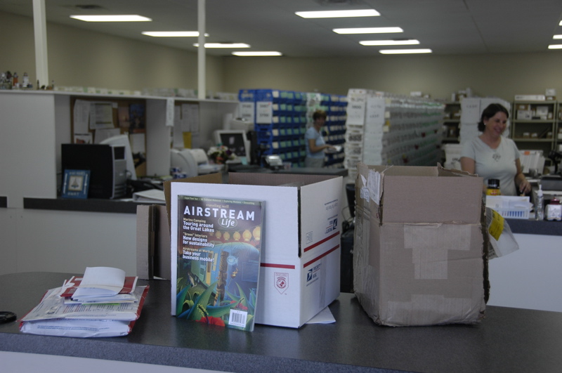
So we met three of the staff, and they met us, and they showed us our virtual home. It’s a box with the number 4468, amid the hundreds of other little boxes in the room, but it contained something particularly special for me: advance copies of the Summer 2008 issue of Airstream Life. (Copies went in the mail this week to all subscribers as well.)
This may seem to be a minor event, but it felt sort of important to me. We’ve put faces with the names, which is always nice when you work across cyberspace with people. We’ve made an appearance. We may never get to Green Cove Springs again, but at least now we know what it looks like, and somehow that feels good. It was always a tiny bit uncomfortable having an address in a place we’ve never been.
Having accomplished that first step of our east coast tour, we started thinking about where to head next. (These brainstorming sessions were held over walkie-talkie, since Eleanor was driving behind me with Emma in the Honda.) All of the beachfront sites are booked solid this weekend, and we didn’t want to fight crowds. We also realized that boondocking or overnight parking outside of campgrounds would be much more comfortable once we got further north. Florida is running 90 degrees every day now, and the southeast in general is experiencing the usual humidity. So we decided to put some miles behind us in order to get into some cooler weather sooner, and open up our options.
Tonight we are parked at a Cracker Barrel in Georgia, just for convenience. Keeping the speed down to 60 MPH all the way boosted our fuel economy by more than 10%, but with that and all the stops, we ended up driving until 7 pm. Hopefully this will be our only such stop on this leg of the trip. We are planning to spend the bulk of the trip in state and national park sites. I’ll lay out that plan over the next few days as it unfolds.
April 25, 2008 at 5:47 pm · Filed under Maintenance, Places to go, Roadtrips
We had a sense that it was a shame to leave St Andrews after only three nights. As Susan said, “I feel like I could spend two weeks here.” It really deserves its reputation as a great place. We’d just barely scratched the surface with the boating and bicycling, and a few hours on the beach, although I wonder if we’d have liked it half as much during Spring Break season.
Getting out of the park we encountered a “dump station delay,” which happens once in a while. Most of the time a stop at the dump station is a brief event, but at popular campgrounds you can get stuck in a line. This time the line was two Class A motorhomes ahead of us. They take longer at the station because of their much larger tanks, but in this case the first guy in line was one of those extremely meticulous types who takes 15-20 minutes to do the job.
After an extraordinary procedure which I won’t go into, he loaded his sewer hose into a plastic basket and proceeded to wash the outside of the hose. I’ve never seen that one before. I have to admit that the hose looked like new, but I’m not sure why that is important. Then the next Class A rolled up and a guy got out at such a slow speed that he should be careful not to get run over by a glacier. We decided we didn’t need to dump that badly, and headed out.
There are two ways to get from Panama City to Tampa. You can head north to I-10 and drive through Tallahassee, or you can take the scenic (and shorter distance) route of Rt 98 following Florida’s Big Bend. We opted for the scenic route and got rewarded by nice views, a bit of construction delay, and better fuel economy. The latter was important since fuel in that area is currently running $3.69 per gallon.
We’re going to have to think carefully about our routing going forward. Highways with high speed limits (as in the western states) are bad for our fuel economy. We do better taking the slow roads, even with the occasional stop sign and traffic light. Anything over 65 MPH dings our fuel bill pretty badly.
The only time we were in Manatee Springs State Park (29 °29’19.55″N 82 °58’34.98″W) was two years ago when Eleanor was having a massive migraine. We stopped for a few hours in the afternoon to let her sleep, but didn’t camp there. Eleanor doesn’t remember the visit, so I wanted to give us all a chance to recapture the place in a healthy moment, and for me, replace that grim memory with some nice ones.
The park features a first-magnitude freshwater spring that runs into the Suwannee River. In the colder months, manatees swim upstream to this spring and others like it in Florida to escape the cold seawater, and so you can easily spot them here. April, however, is the end of the manatee season and during this visit we didn’t see any.
Instead, the water was alive with mullet, placidly floating in the crystal-clear water and facing upstream like a football team awaiting the kickoff. The mullet jump out of the water at random and clear often clear it by a foot or two, which is fun to watch. Sturgeon are also found here, but not during our visit, and deer were as plentiful as squirrels.
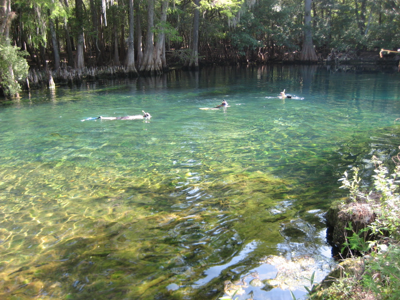
This morning we dragged Emma out of bed (an hour earlier than she was ready for, because we crossed into Eastern Time yesterday), and Adam, Emma, and I all climbed into the 72 degree water at the headwaters of the spring for a morning snorkel. I can recommend this practice. There’s nothing like a swim in the morning to start off a great day. Of course, a wetsuit makes the water a lot more pleasant.
Perhaps having a serene feeling helped me deal with what came next. Just a few miles from the campground, our brake controller stopped working. I touched the brakes and that reassuring tug from the trailer wasn’t there. Then I stepped harder on the brakes and felt the trailer pushing against us as we drifted to a stop at the red light.
Those of you who have followed this blog can probably appreciate my feeling when I realized, in traffic, that we had once again lost our brakes. This time it was not on a downhill ramp in the rain, but the feeling of “omygodherewegoagain” certainly was overwhelming all the same. I flashed back to the last time, in Oregon, when the brake actuator suddenly died, and how we ended up waiting for days for a replacement unit to be shipped in, and then dealt with brake bleeding aggravation for days afterward.
We radioed Adam and Susan, who were behind us, and pulled over in the next available dirt lot for an inspection. I checked all the obvious culprits: trailer umbilical connection, corrosion on the contacts, fluid level on the actuator, wire connections to the actuator, fuses, but everything was fine. So I called up Actibrake’s tech support and asked for help, fearing the worst. Being Friday, I could just see us parked at the nearest campground for the next four days awaiting a replacement unit again.
Fortunately, Mike Adamietz of Active Technologies was a real pro, and very calm. (I was trying not to get really upset, but I’m sure some of my stress leaked through the phone.) He ran through the troubleshooting checklist, but I had checked everything on it already, except the last item. The unit was making a light “thump” sound every few seconds for a minute or two after we stopped. Mike recognized this as a possible low-voltage condition and asked me to check the trailer ground wire.
I had never looked at our ground wire, even though it is located out in the open in front of the trailer. This is the ground for everything in the trailer’s 12v system. Since the other 12-volt appliances in the trailer worked fine, I had not considered it, but it turns out that the actuator pulls a hefty 15-20 amps, and so a corroded ground can affect it before anything else appears awry.
Sure enough, simply by removing the ground wire, brushing it briefly with copper wool, and replacing it, the problem was solved. I can’t begin to describe my relief. I was also grateful to have a pair of supportive friends behind us (along with the ever-supportive family), and glad that Mike was right there to help us over the phone. So with that, we proceeded down the road to Tampa, with that reassuring disc braking feeling once again.
The ground wire is such an easy maintenance item and so important that Eleanor and I shot an instructional video on it, and posted it on the Airstream Life media community. You can see it here.
April 21, 2008 at 9:07 pm · Filed under Roadtrips, Tips & Ideas
Our “no reservations” policy is being sorely tested. All along our route since we got to east Texas, campgrounds have been hard to get into. We snagged the last two spots at Pecan Grove in Austin, among the last spots at Bayou Segnette near New Orleans, and today we were skunked at three places in the Florida panhandle: Henderson Beach State Recreation Area, Topsail, and Grayton.
We normally don’t worry about being turned away, for two reasons. First, we usually avoid popular places during popular times. Our last trips through the panhandle were in March and December, and we had little trouble staying wherever we wanted, except around Spring Break.
Second, we are not normally concerned with being at a specific campground. If one is full, we keep on truckin’ in the general direction we were heading and find something else. This has given us some of our most memorable adventures and encouraged us to try places that we otherwise wouldn’t consider. That may sound bad, but in most cases it has been very rewarding.
But we are traveling with other people now, and this has forced a change in pattern. I can’t get our friends to appreciate the irresponsible joy of “potluck camping.” Like most people, they would like to have a plan, and know where they are going. It’s not comfortable for them to go bare and take what comes at the end of the day.
I can understand that. People with limited time want to get the most out of that time, and a couple of nights in a grungy campground with no view (or a Wal-Mart, if things really go awry) is disappointing when they were hoping for the beachfront. We’re more willing to accept the occasional night sleeping behind an industrial building or gas station that most people because we know it all evens out over time … and as full-timers, we have the advantage of time.
Also, I think most people like to have some certainty at their destination. There’s a comfort that comes from pulling into a campsite at the end of a long day where you have a clearly delineated space that is designated as yours, a gate up front to keep strange events at bay, and a welcoming staff that wants you to be there.
It takes a certain personality to look forward to the challenge of driving into a strange town, and completely winging it on the campground. It’s an even rarer personality who, if traditional camping fails, enjoys scouting out the parking lots, churches, and local parking laws, and then picking some spot where you may not be completely welcome. Most people aren’t up for that possibility when they are tired from a long day of driving, but we’re used to it.
But not when we are two RVs traveling together. It’s too much to ask that people follow us around town while we hunt for odd little overnight parking spots. Eleanor and I have a very finely honed process for determining where we will stay, which we know well but have trouble explaining to others. From where they are, looking at our taillights on the highway, I’m sure it looks like a completely random and confidence-sapping process.
Today, after being told the bad news by the staff at Henderson Beach SRA, we had a moment of group flustration while we considered the options. The state beach parks are very popular this time of year and reservations are a good idea, but until a couple of days ago we didn’t know for sure when we’d be here. There were commercial campgrounds with availability, but they were either outrageously expensive “resorts” (one place we tried was $79 per night, not surprisingly it had lots of open spaces), or really lame wrong-side-of-the-highway places.
In the end, it took Adam’s marvelous skill at ingratiating himself with people to get us into St Andrews State Recreation Area, in Panama City FL. It’s a popular place, and the staff wouldn’t promise us a spot over the phone. Eleanor called and got no useful information, but Adam called a few minutes later and somehow managed to do considerably better.
When we arrived at St Andrews, there were at least a dozen open sites, but since it was after hours we were not able to verify if we can have them for more than one night. In the morning we’ll check in with the office and see if we can stay a bit longer. Now that we are here, it looks like a nice place to hang out for a few days. So it worked out. After all, we wouldn’t have come here if we had made reservations somewhere else.
Our coordinates: 30 ° 8’5.46″N 85 °44’5.94″W
« Previous entries ·
Next entries »
