Archive for Places to go
May 30, 2007 at 8:50 am · Filed under Places to go
It is amazing to come to a national park after having seen so many incredible national parks, and being blown away once again. That’s the amazing thing about America’s national parks. They are all worth a visit. We just can’t get enough of them.
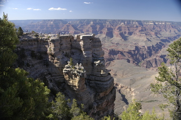
Grand Canyon is, as we expected, spectacular and inspiring. I really want to go for a hike down into the canyon to the Colorado River, and camp for a night or two at the bottom, but that’s not possible in this short visit. Also, I’ve been told that you need to make reservations months in advance for the mule-camping trips. We’ll get the lay of the land on this three-night stay and plan another long trip for next year.
We’ve gotten a small taste of the south rim so far, by hiking part of the Rim Trail, riding the shuttle bus around, attending a campfire program, and starting Emma’s latest Junior Ranger program. Today our plan is to browse the rest of the Rim Trail, drop in on everything along the way, and attend a Ranger Talk. No rush, just a leisurely walkabout.
The altitude here means a few adaptations. We’re at 7000 feet and so it cools off quickly at night. Last night it dropped into the 40s. Also, we all felt a little tired at first, which is a result of the thinner air. Based on our experiences last summer at high altitude in Colorado, we should adjust quickly.
The “Trailer Village” (the only place in the park with hookups for campers) is not particularly attractive, but it is very convenient and has all the amenities (store, full hookups, even cable TV!) We’re not spending much time at the Airstream, however. It’s easy to hop on the LNG-powered bus and get anywhere in the park in just a few minutes.
Our reputation seems to precede us. Only a few minutes after arriving, one of the park volunteers drove by and said, “You’re that Airstream Life guy!” Turns out she knows David Tidmore of Roger Williams Airstream and has followed the blog. Another “small Airstream world” story.
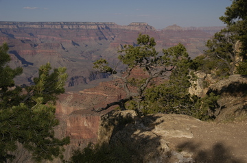
(As with most pictures on the blog, you can click these to see a larger version.)
This blog entry comes to you courtesy of someone in the campground with a satellite connection and an open wi-fi signal. Thank you, “WhitewaterVideo”. When we are camped in a remote spot and our Verizon cellular Internet system works, I always leave my wifi open for others to share, and it’s nice that someone has returned the favor.
May 6, 2007 at 6:07 pm · Filed under Places to go
The neat thing about Catalina State Park is that it feels completely remote, with amazing views and wonderful hikes, yet is directly adjacent to all the services of Oro Valley and Tucson. Convenient, yet peaceful.
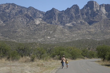
The real reason we are here has nothing to do with the hiking, however. Once we complete the purchase of our house, Catalina is a park we’ll probably never camp in. It’s too close to home. So camping here a couple of days before we pass papers for the house is sort of a last-chance opportunity.
Our Google Earth location.
Another last-chance opportunity is hiking in mild weather. This time of year it’s not unusual for the weather to be in the 90s and to start breaking into the low 100s. But right now we’re having a few cool days, topping out around 78 or 80 degrees, so it’s perfect for hiking. By the end of this week, we’ll be more inclined to head for the swimming pool.
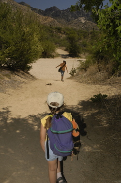
Our hike today was about three miles. We concentrated on butterflies, since they were out in abundance today. It’s tough to capture a butterfly in flight, but I got a few blurry shots, enough for Emma to identify a Pipevine Swallowtail, and a Sleepy Orange. A few others escaped without identification, like masked robbers at a 7-11. We’ll catch them next time!
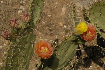
The other marvelous thing about the desert this time of year is that the blooms just keep coming. I am amazed at the diversity and intensity of the colors. There are several types of prickly pear cactus that grow here, and their flowers range from peach to rose to bright yellow.
Sometimes you can find all three colors on a single cactus. They are lovely enough in their form and color to be a prom corsage. I wonder if anyone has actually tried that? The spines can be easily trimmed off, much like the thorns of a rose.
A small announcement. Trailer for sale. I have decided to sell the 1953 Airstream Flying Cloud I found last fall in Virginia. I was hoping to take it on as a project later this year but it doesn’t look like that will happen, so it’s for sale. You can see photos of it as found in our Flickr photo album.
Since the photos were taken, the trailer has been moved to Plattsburgh NY, cleaned up a bit, and otherwise left alone. It’s a very interesting trailer with all original appliances and a great layout for one or two people. But it does need a good restoration. As-is, where-is, $3500 or best offer. Colin Hyde will be happy to restore it for you, too.
May 4, 2007 at 4:28 pm · Filed under Places to go
We learned a few things today, as we seem to do every day when we are adventuring. This lake we are camped beside is the result of a massive dam-building project from the early 1900s. When it was completed in 1911, the Roosevelt Dam was the largest masonry dam in the world and it caused the largest man-made reservoir to be formed behind it. Teddy Roosevelt himself came down here for the opening ceremonies and to hand out awards to the workers.
The level of the lake fluctuates quite a bit, like other man-made desert lakes. I mentioned to our real estate agent that we were here and he asked, “Is there any water in it?” Yes, we seem to be here at a high point. The lake is about 20 feet down from the apparent high-water mark, but still very full relative to other years.
People occasionally zip by on jet skis or fishing boats. There’s plenty of room, since the lake continues north-south for many miles. About four miles from our campsite is a visitor center for Lake Roosevelt, next to the marina, and it has a good interpretive area with information about the dam, the wildlife of the area, and native American history.
For more on the native Americans, called the “Salado”, you can drive south two more miles to Tonto National Monument. This smallish member of the national parks system protects Salado cliff dwellings high above Lake Roosevelt. The dwellings are found about 350 feet vertically above the visitor center and reached by a half-mile steep hike.
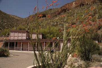
Visitor Center with dwellings far above
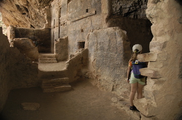
The Lower Cliff Dwellings are mostly gone, victims of erosion and vandalism in the early 20th century, but there’s still enough left to make it worth the hike. At some times of year the rangers will also lead a daily trek to the Upper Cliff Dwellings but we missed that on this visit.
Another reason to make the hike is the incredible view of the Tonto Basin and the lake. We were lucky to find many of the cacti still blooming, as well as turkey vultures making slow and majestic circles above.
The turkey vultures aren’t the only things flying around. The entire Tonto Basin has a large number of insects this time of year too. Normally we don’t encounter a lot of bugs in the desert, or even the higher elevations such as last week in Prescott. But here there’s plenty of water to encourage breeding and it’s springtime. Nothing seems to bite but a lot of little flies made themselves annoying on our hike, at times when the wind died down.

Emma picked up the Junior Ranger packet and completed the questions on the way down, thus earning her 17th Junior Ranger badge.

Last night we took a short walk around the campground and found a messy site. Some slobs left trash all over their site, including plastic bags, empty beer cans in the fire ring, and a quarter-bag of charcoal. I have never understood why people so often leave crushed beer cans in the fire ring. I see it all the time. Do they think aluminum cans burn?
The residents of the campsite were clearly long gone, so Eleanor did her good deed for the day by cleaning up the site and I snagged the charcoal. So we have a surplus of choarcoal and that means tonight we will cook out.
May 2, 2007 at 11:25 pm · Filed under Places to go
Today Prescott returned to the fine and sunny weather we’ve become accustomed to, but work trapped me in front of my computer most of the day. I finally broke away in the late afternoon for our second hike over the rounded granite of the Dells.
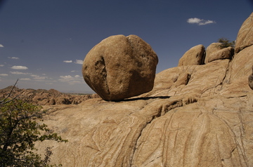
It’s an incredible playground out there. Everywhere are canyons, cliffs, stairways, and shelters formed of rock. You can wander around and climb in them for days and not see it all. And despite the initially barren look of the place, there are many animals as well. A long Arizona Mountain King Snake crossed our path, along with more common creatures: squirrels, violet-green swallows, hawks, lizards, and even a skink about six inches long.
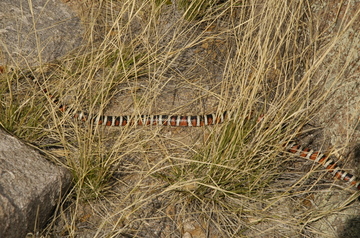
The snake is a rough look-alike for the venomous Coral Snake, but I caught the picture above before he slid out of sight and so we were able to positively identify him when we got back to the Airstream.
Once again the Dells proved to be a photographic delight, and so I’ve uploaded some new images to the Prescott album on Flickr. It was easy to get some nice shots with just a short zoom, a circular polarizer and a flash.
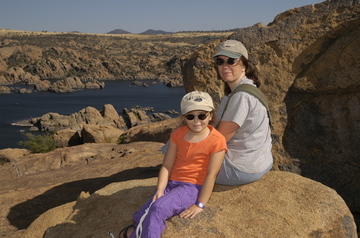
This is our last day in Prescott. We are going to wander over toward the Mogollon Rim, east of here, and then southward toward Tucson over the weekend. It’s hard to leave Prescott but I’m sure we’ll be back. Next time, I’m hoping to have a mountain bike and maybe our tent camping gear too.
April 25, 2007 at 8:04 pm · Filed under Places to go
Only 60 miles up I-10 from our spot in Tucson is a beautiful patch of open desert with a stark jagged peak standing up. This is Picacho Peak, centerpiece of Picacho Peak State Park, our home for the next two nights.
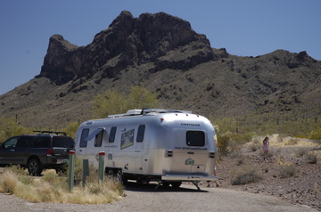
I am impressed with the beauty of this park. It sits on a small rise above the desert floor, so that almost everywhere you go the view is magnificent. Because it’s a low altitude park (and thus already getting warm this time of year) this is the off-season and there are few people here. We had our pick of spots.
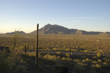
The interstate highway and a freight line run down below the park, but we can hardly hear them.
We chose the non-electric loop just for fun. We’ve had full hookups for months now, and it feels like time to do a little boondocking again. There’s so much sun now that it’s hardly a challenge, at least from an electricity standpoint.
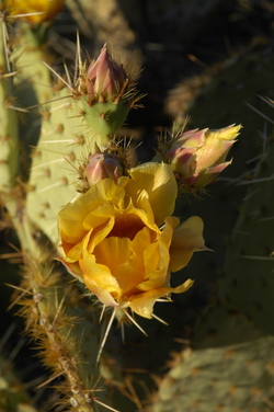
Photographically this park is wonderful. As the sun moves, every view changes right up to the last second of light on the horizon. There are all kinds of plants and creatures living on this tiny island in the desert, and right now a few of the cactus are flowering. In just an hour hiking around I managed several nice photos, which I’ve posted on Flickr.
The heat has arrived. Today it was 90 and so we spent the afternoon with the fans running, some cold drinks, and a book for everyone. By 5 pm it was cool enough to go for a short hike and do some scouting for a big hike tomorrow. Since it will be hot again tomorrow, we’ll try to get an early start and hike all the way up to the peak.
Google Earth location of our campsite at Picacho Peak State Park.
April 19, 2007 at 9:14 pm · Filed under Places to go
Just down the road from our campsite is one of the better-preserved ghost towns of southern Arizona, a town called Fairbank. It was a stop along the railroad line, complete with school, hotel, miner’s homes, a post office, and more.
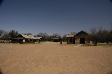
The rail line has long been abandoned, and now Fairbank is just a patch along the San Pedro river. The schoolhouse remains, converted into a one-room museum, and a couple of other buildings in decrepit shape. Some interpretive signs are there, along with trails to the river, the old stamp mill, and Fairbank cemetery.
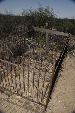
The cemetery is a half-mile walk from town. An old story is told which claims that bodies bound for the cemetery would be floated down the San Pedro River, but it’s probably not true. We took the hike to check it out, and it turned out to be a hilltop with a panoramic view, strewn with rock-covered graves. Few of the graves are marked, but they can be easily identified by the piles of stones and an occasional wood cross. Only a couple have elaborate metal surrounds, like the one above.
The cemetery was surprisingly eery. I think it was the closely-spaced, unmarked graves. Each one gives the impression of someone resting only inches below the surface, and the entire place is sort of lonely. We’ve been in many graveyards in New England that are much older than this one (dating from the late 1800s through about 1920), but this one definitely wins the prize for the spookiness. I’ve posted more photos on our Flickr photo album.
Google Earth location of Fairbank Cemetery
Twenty or thirty miles down the road, past Tombstone, is the old copper mining town of Bisbee. The copper is all played out, and now the town is known as an artists community. Bisbee is known to us for two reasons: It’s Eleanor’s favorite place to buy beads, and it’s the home of The Shady Dell RV Park. The Shady Dell is a sort of trailer motel where you can rent a 1940s, 1950s, or 1960s vintage trailer by the night. We stopped in to check it out and talk to Ken, who runs the place.
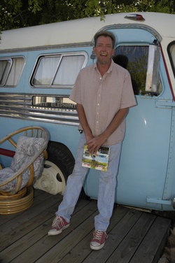
Ken leaning against a “Flxible” bus
The Shady Dell is for sale, if you want to own a very funky trailer park with a collection of restored trailers. Ken would like to stay on and continue to manage it, so it’s a great opportunity for a vintage trailer nut who wants to be an absentee owner. Hmmm… wish I had the money.
Google Earth location of The Shady Dell
April 18, 2007 at 7:36 pm · Filed under Places to go
One of the reasons we are here was to explore Ramsey Canyon, a Nature Conservancy site near Sierra Vista. It’s part of a “sky island” formed by the Huachuca Mountains. Sky islands are biologically diverse high altitude areas found in the southwest, primarily Arizona and New Mexico.
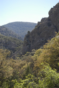
Ramsey Canyon sits at the confluence of two mountain ranges (Rockies and Sierra Madres) and two deserts (Chihuahuan and Sonoran). Thus, it has bird, plant and animal life from all four of those areas, making it a unique place for naturalists and the curious travelers like us.
It’s also a great spot to experience the variations Arizona can offer. Hiking in Ramsey Canyon was just like a hike in the Green Mountains of Vermont, or the White Mountains of New Hampshire, except without mosquitoes & black flies. A burbling brook tumbled down the canyon, just parallel to the trail. Deciduous trees and butterflies surrounded us. The major clues that we weren’t in the northeast were the occasional yucca and trees we weren’t familiar with such as the Arizona black walnut.
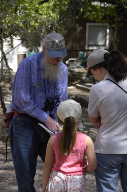
The canyon is well worth the short drive from Sierra Vista and the $5 admission charge. There’s a small nature center, and naturalist volunteers are standing by to help interpret the park and identify creatures. We spotted a screech owl nesting in sycamore tree, several hummingbirds, numerous butterflies, the endangered Ramsey Canyon Leopard Frog (no kidding), and the hiking was excellent. In fact, we plan to go again and do a longer hike. The admission receipt is good for a week.
If you go, I’d recommend good birding binoculars and plenty of water. The trail is all uphill, but not very challenging until you’re about 1/2 mile from the nature center.
Google Earth location of Ramsey Canyon
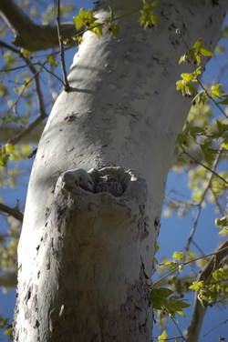
You’ll have to look very closely to spot this well-camouflaged screech owl!
« Previous entries ·
Next entries »


