Archive for August, 2006
August 10, 2006 at 10:48 pm · Filed under Uncategorized
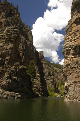
We had conspired to take the Morrow Point Boat Tour this morning before heading south to Creede. The National Park Service has a tour down the Black Canyon of the Gunnison where it becomes the Morrow Point Reservoir, on a 42-passenger pontoon boat, and it seemed like a fine way to wrap up our stay in Gunnison.
But this morning, as I was making our pre-flight checks, I found that one of our tires had gone flat. Yes, another flat tire. Was our luck about to turn ugly again?
Fortunately, the tire had only a slow leak. We refilled it with Rich C’s portable air compressor (mine does not have a long enough cord to reach the driver’s side — something I’ll have to rectify) and the tire held air. But since we don’t currently have a wheel for our spare, we needed to get the tire fixed immediately. I figured that the trip downtown to get a tire patch would make us late for the boat trip, so we resigned ourselves to spending yet another day at a tire shop — and losing our non-refundable fares for the boat tour.
The Tour of America, or Tour of America’s Tire Shops?
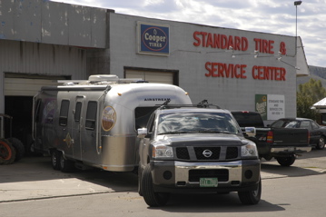
And then we got lucky. The second tire shop we tried was willing to squeeze us in, and the problem was located and fixed in about 20 minutes. (It was a small nail this time, right through the center of the tread.) I stopped the mechanic and gave him a short synopsis of our previous tire/wheel problems, wrapping up with, “…. and so that’s why I want to torque the lug nuts myself, OK?”
He was amenable to that, and just spun the nuts on loosely. I carefully tightened them using the procedure I had learned back in Green River, WY, and checked them five, ten, and 25 miles later. This little episode only cost us $20 and about 45 minutes including hunting for tire shops so we decided to see if we could still make the boat tour.
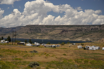
We drove about 10 miles west on Rt 50 to the Elk Creek Visitor Center, unhitched the trailer in the parking lot (with permission), and raced another 15 miles west to the parking lot for the boat tour. From there, it is a hike down 232 stairs and along 1/2 mile of abandoned railroad bed to the boat launch on the Gunnison River in a deep canyon. We made it, with ten minutes to spare!
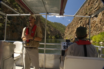
Our tour leader and Capt. Tom told me later that they were actually going to wait for us. Apparently the rangers at Elk Creek radioed ahead to tell the sad tale of a family who got a flat… in fact, by the time we arrived, all 39 other guests on the tour were aware of our story.
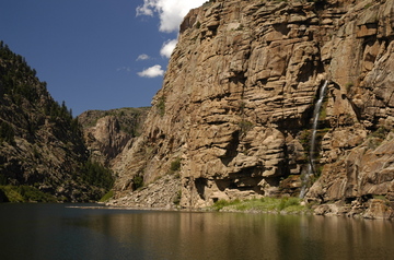
Click for larger
The tour takes about 1.5 hours and is spectacular. The canyon walls rise from 100-300 feet up to several hundred feet, as it widens into the Morrow Point Reservoir. There are a lot of interesting sightsalong the way including the waterfall pictured above, an old narrow gauge railway bed, hawks & vultures soaring above, caves in the rock walls, and beautiful calm waters.
After the tour we hiked back up the 232 stairs and over to Elk Creek again, where Emma picked up her 14th Jr Ranger badge and we hitched up for the trip over to Creede. Route 149 to Creede is predictably scenic, but that also means curvy, hilly, and remote. It took us nearly three hours to drive about 100 miles, mostly because of the 11,500 ft Slumgullion Pass just past Lake City. Speed limit on most of the southbound (uphill for us) portion of the pass is 15-25 MPH most of the time, and so we climbed the hill rather slowly in first gear. But it was a troublefree climb and descent.
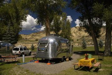
We are in Creede at the rally campground now. When we arrived it was pouring rain and absolutely dismal so we stayed in and haven’t seen anyone yet. There are at least two dozen cool vintage Airstreams here already, and more than 30 more expected tomorrow. I’ll get pictures … and I’ll get the new rim from David Tidmore when he arrives, so we can get our spare tire mounted on it for the NEXT flat.
August 9, 2006 at 9:49 pm · Filed under Uncategorized
We spent part of today exploring the downtown of Gunnison. It’s a small town, but everything is there, from the western outfitters to the old barber shop. Uptown you’ll find the newer places such as Wal-Mart and the quickie oil-change place. We stopped to get the oil changed and found ourselves in line behind Rich C’s Titan.
I think you can learn something about a town from the architecture you find. In Gunnison, you can find …
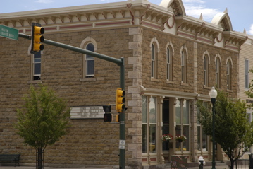
a beautifully maintained stone Victorian …
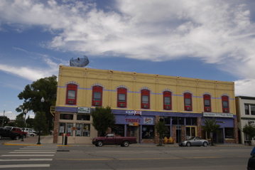
a colorful former hotel …
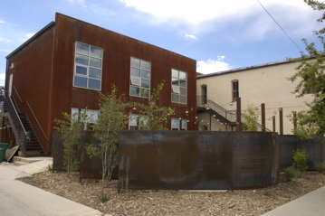
and an industrial-style artist’s cooperative, complete with welded steel fence — all within three blocks.
To me, this indicates a town with vivacity, a sense of community, and history. I’m sure we’d like to live here, if it weren’t unbelievably cold and snowy all winter. But we’ve been warned by locals: this is nothing like “banana belt” Salida, even though the altitude is similar. I can believe it. Each evening we’ve felt the wind rise and the temperatures plummet. It’s nice now, but I don’t want to be here in December!
August 8, 2006 at 9:43 pm · Filed under Places to go
After Eleanor and I got a few hours of work done this morning, we packed up a picnic lunch and headed to Black Canyon of the Gunnison National Park, about 50 miles west of here.
Along the way we saw all the great campgrounds we would have liked to have stayed in this week. The Blue Mesa Reservoir starts just a few miles west of town and there are several great National Park and commercial campgrounds right along side it.
A little further down, we spotted a pair of vintage Airstreams parked in a tiny roadside campground. Linda Hogan was there reading a book next to a burbling stream. We last met Linda in Sisters OR at the vintage rendezvous just before the International Rally. She and her fellow travelers will be at the Rocky Mtn Vintage Rally later this week.
Once again, Colorado has amazed us with its splendid scenery. Just the drive along Rt 50 is worth the effort, but then once you arrive at Black Canyon of the Gunnison NP, the vertical scale of the canyon is downright stunning. My pictures can’t possibly do justice to the incredible overlooks. The walls of the canyon are decorated with crazy lines of pinkish pegmatite amidst the darker schist.
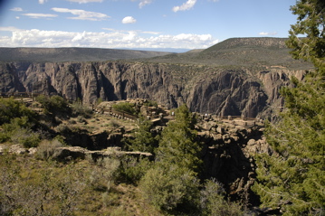
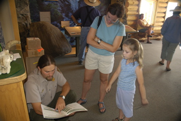
This is our kind of park — uncrowded, photogenic, and remote. We spent over an hour in the Visitor Center alone, and of course Emma scored another Junior Ranger badge — her 13th, I think.
By the time we left, it was past six and we had to hustle to get back to camp by 7:30. I grabbed a quick bite for dinner and headed up to a nearby Recreation Area with Rich C to get some sunset photos.
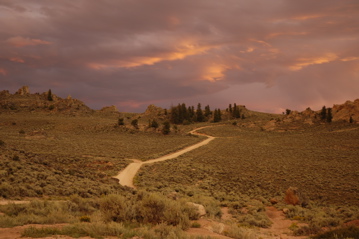
The light and the scenery were unbelievable at sunset — a photographer’s paradise. Both Rich C and I shot dozens of photos while we were up there. All of these photos were shot without filters.
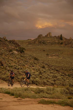
The area is riddled with mountain bike trails, 4WD trails, and fantastic rock spires. We may go up again tomorrow, since it is only five minutes from the campground. The dirt roads generally require a high-clearance vehicle, but they go on “forever” according to the locals, from the recreation area to BLM land to National Forest. We’ll take the Nissans and go exploring.
August 7, 2006 at 7:47 pm · Filed under FAQs
A blog reader who shall remain only partially anonymous (Brad A) wrote me today to ask:
Do you use the Passport America discount on your trip? I’m just starting to check it out for our route, and it looks like it’ll pay for itself pretty quickly, like a the national parks pass. It’s one of those things that seems like such a good deal, it must be a trap- maybe they coax you into a box, and you wake up drugged and are forced to sew Nikes somewhere in the Phillipines.
We just started using Passport America in northern California, when Rich C dragged us to a place in Klamath that offered the PA discount. We bought a PA membership on the spot and the first two days discount paid for about half the cost of the membership.
What we’ve found is that those places that offer PA tend to be the ones at the edge of town or in the less-desirable spots. That doesn’t make them bad, but because of their locations we end up only using PA places once every few stops. I think at this point we have spent about 10 nights in PA camps and 7 or so of those were eligible for the discount rate. That easily paid for the membership, since most nights are discounted to about half the regular rate.
When we are looking for a place to stay, we go down this list:
1) National Parks
2) State Parks
3) Courtesy parking
4) Boondocking in remote area
5) County parks/ BLM camps/ Corp of Engr camps
6) Commercial campgrounds w/ PA discount or KOA discount
7) Wal-Mart, Cracker Barrel, Camping World, casinos, etc. (if staying only one night)
8) Gas stations, empty parking lots, etc.
9) Commercial campgrounds with no discount
10) Highway rest areas (extreme desperation)
Keep in mind that this list is oriented to our interest in natural areas, socializing, and cheap camping. We don’t feel the needs for full hookups unless we are going to be staying for longer than four days. Other people feel differently, so you may not agree with the order we use. Still, with this policy we have managed to keep our campground expenses generally under $300 per month.
Of course, the order of the list can change if weather is extremely hot (A/C needed) or we need to be in cell phone or Internet range. That’s why today we are at the KOA in Gunnison rather than at some very beautiful campsites a few miles west of town near the lake. Cell phones don’t work over there, and I have work to do this week.
I think PA is a good deal if you camp a lot. Keep in mind that not every place offers the discount every day. Some are restricted to 2 nights, or weekdays only, etc. It works best if you have flexibility in where you want to stay.
We keep the PA guidebook under the front seat with the atlas and the KOA book. I’m planning to add books on Corps of Engrs campgrounds and BLM campgrounds to the pile. Rich C swears by “Don Wright’s Guide to Free Campgrounds” as well.
If anyone has a guidebook that they recommend, post a comment here and share it with everyone!
August 6, 2006 at 6:05 pm · Filed under Uncategorized
Reluctantly we left Roger and Brenda behind this morning after visiting the site where they are building their new home in the foothills near Salida. The views in Salida improved this morning, with a temporary lifting of the clouds, and showed us how spectacular and panoramic the views are in Salida this summer. But it wasn’t long before the thunderstorms began building again, as we began the long climb up to Monarch Pass on Rt 50.
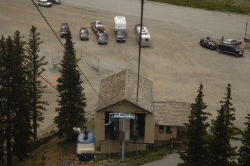
The grade is only 6% up to Monarch Pass, but the road climbs and descends for about ten miles on each side. At the peak, we reached 11,312 feet and paused to ride the Monarch Pass Aerial Tram another 700 feet up a very steep peak.
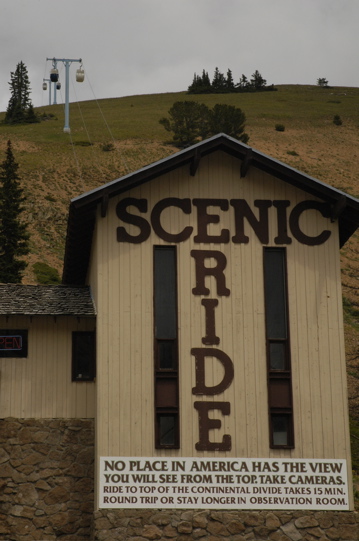
The reason I felt obliged to stop is that we’ve got an article coming up in a future issue of Airstream Life about aerial trams … and this is one the author hasn’t yet covered. So I took pictures for the magazine and some notes. My major note is that very steep vertical climbs in aerial trams make me really nervous.
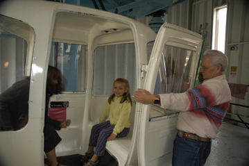
But Emma and Eleanor loved it. It was fun, but I was glad to get off it all the same.
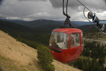
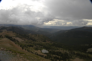
Definitely don’t forget your camera on this trip. It’s short but very impressive. Several mountain ranges are visible from the top, and you can straddle the Continental Divide from the observation deck at the top — from an altitude of 12,000 feet.
Everything worked fine in the Nissan and Airstream too. No problem towing up to 11,300 feet, and nothing exploded in the trailer. Last year when we went over 11,000 feet a bag of sour cream and onion chips went poof. And hey, all the wheels are still on!
Everything in Gunnison CO was booked except the KOA next to the airport, so that’s where we ended up. It’s a good thing we don’t mind the sound of airplanes running up their engines, and taking off. (In fact, I kind of like it — reminds me of going to Oshkosh and Sun’n’Fun.) We’re parked on grass, our cell phones work, we have free wi-fi, and that’s all pretty incredible considering how small Gunnison is and how remote we are.
Rich C came to meet us, up from his base in Cortez CO. We’ll spend the next three days checking out stuff in the area. There’s a lot to do. Tomorrow will be mostly a work day but then we’ll get to Black Canyon of the Gunnison National Park and a few other things too.
August 5, 2006 at 9:28 pm · Filed under Uncategorized
We moved the Airstream from the Wal-Mart lot over to a space next to Roger & Brenda’s house. Even though it’s only a hundred feet on the other side of the fence, it seems so much nicer here. We still haven’t plugged in, since I wanted to see how the solar system performs on cloudy days. (With mixed sunshine and clouds, we easily were re-charged in a few hours.)
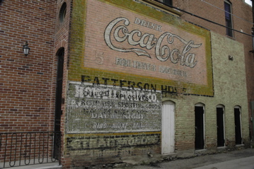
We spent most of the day in the historic downtown of Salida. The commercial section is only about three blocks wide and five blocks deep, but it’s filled with interesting shops, parks, and restaurants. One of the interesting little features of Salida is the commercial art painted on the sides of the brick buildings. The more you look for it, the more you’ll notice. I shot pictures of at least a dozen good examples.
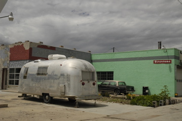
Wandering around, we found a 1966 Airstream Safari parked right in front of what used to be a Firestone tire shop. The owners are artists who use the building for workspace on the weekends. We told them about the upcoming Vintage Rally in Creede and they are thinking about dropping in for a day.
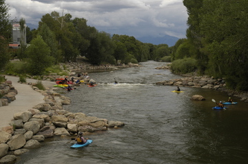
Kayaking along the river, downtown Salida (click for larger).
The foot of downtown is defined by the river. It’s ideal for practicing whitewater kayaking, with long gentle sections of quickwater punctuated by small drops and standing waves. I was able to get in close to the kayakers practicing flips and get some great action shots.
I’ve uploaded a bunch of photos from Salida to the Flickr photo album.
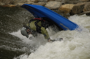
An intentional forward flip. Click for larger.
Salida is a neat place with a unique climate. Despite being at 7000 ft, it gets very little snow. The valley is surrounded on three sides by 14,000 ft mountains, which squeeze the moisture out of the air. As a result, most winters experience only a couple of good snowfalls which disappear quickly. They get less snow here than Denver or Colorado Springs, and 315 sunny days a year.
But not this week. It has been unusually wet this summer, and has been raining regularly each afternoon, like Colorado Springs was doing to us last week. We don’t mind the rain, having seen very little of it, but all the same it is hard to believe the locals’ claims that the place is normally parched, when everything here is so very green and lush now.
August 4, 2006 at 4:08 pm · Filed under Uncategorized
We’re moving again, and as always it’s an interesting challenge. Our drive from Colorado Springs southwest to Canon City was sunny and uneventful. We took a four-mile detour off US-50 to go see the Royal Gorge Bridge, but I was disappointed to find that you can’t even walk on the bridge without buying an expensive admission ticket to the “Park” that goes with it.
We were only there for a quick look, so instead of going in, we parked up in Lot B (overflow area) with a few other RV’ers and had lunch with a gorgeous 360-degree view of the mountains. From our lofty spot I was able to receive Sprint and get online to do a few last-minutes pieces of business during lunch, which was a bonus.
If you go to the Royal Gorge Bridge area, you will find no end of places to spend money. There’s a Royal Gorge Route train that goes through the canyon below the bridge ($39 adults, more for 1st Class or meal service), a narrow-gauge railway that goes near the bridget ($9), a bunch of “western” towns with shoot-em-up shows, the Royal Gorge Bridge and Park itself, gift shops galore, and numerous other attractions. One could be forgiven for thinking that the bulk of Canon City’s economy is based on the bridge.

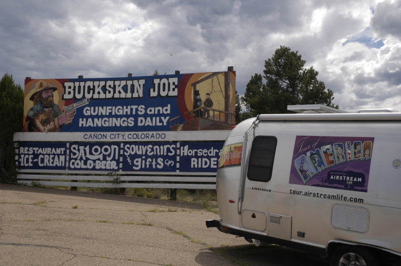
Another place that did not get our tourist dollars today
Our plan today was to drive up to Salida to meet with Roger and Brenda Roelfson. We met them last October in Denver and I interviewed them for the magazine. They used to live in Mississippi. You can read their story of fleeing Hurricane Katrina in the Spring 2006 issue of Airstream Life magazine (look for the article “Silver Survival Pod”).
About nine miles east of Salida we found the last public-lands campground before town, along US 50 bordering the Arkansas River. Rincon Campground is in the Arkansas Headwater Recreation Area, which intermittently follows the road. It’s a pleasant enough spot and a great starting point for fishing or rafting, but close to the highway.
We called Roger from Rincon, thinking we’d spend the night, but it turned out that the house is next to a Wal-Mart Supercenter in Salida. Hmmmm…. pay $14 for a campsite by the highway with no services and have to drive 9 miles back and forth to the Roelfson’s house, or pay $0 at Wal-Mart for a parking space by the highway with no services and walk next door to dinner?
So we drove into Salida and here we are parked only a hundred feet from our hosts, on asphalt provided by Wal-Mart. Eleanor went into the store and stocked up on groceries for the next two weeks, thus assuring that Wal-Mart is happy with our presence. And I am communicating with you courtesy of Roger’s wi-fi, which I can receive in the trailer using my little Linksys repeater. Not bad.
« Previous entries ·
Next entries »