November 7, 2005 at 4:39 pm · Filed under Eleanor's posts
Inevitably, I get the question”¦ “Don’t you miss your house”? “¦
Invariably, the answer to the question has always been no. “¦
At least it was until this past Saturday morning. “¦
This blog has been posted in its entirety on Gather. You can read it there if you like. Click the link for “Gather” or visit http://airstreamlife.gather.com
November 7, 2005 at 3:38 pm · Filed under Places to go
This is a fine place. Nevada City certainly ranks among the most historic places in California. This is gold rush country, in the foothills of the Sierra Nevadas, downstream from old mines and sluices and Ponderosa pines.
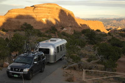
Last night we courtesy parked at the house of the Trent family, squeezing the 30-footer into a spot formerly occupied by their recently-polished 1964 Safari, named “Pearl”. (For a picture of Pearl, see http://www.velocity7.com/blog/index.php/2005/10/ ) She has been displaced to the driveway during our visit, which is expected to be three days.
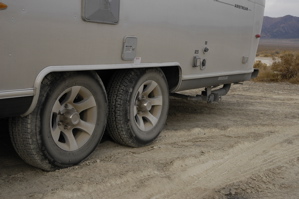
On our way over, we stopped off at a truck wash near Fernley NV to clean up the rig. That boondocking stop in the desert left us covered with salt. Fortunately, the Airstream cleaned right up in the truck wash, and now we’re shining again!
This morning, Robert took me over to the Velocity7 world headquarters in his 1964 Dodge Dart (a really cute vehicle, by the way). I’m borrowing some desk space and Internet connection for the next couple of days.

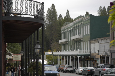
The office is located in downtown Nevada City, which is a destination in itself. The buildings mostly date from the late-19th century, such as the brick 1886 National Hotel …

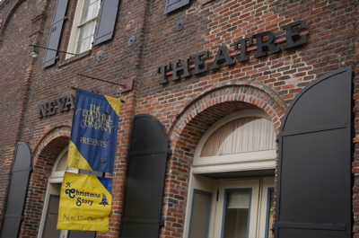
… and the 1865 Nevada Theatre (the longest running continuously-open theater west of the Mississippi, I am told).
The whole downtown is lively, architecturally interesting, and has the feel of a restored historic town without being a tourist trap.
Just up Rt 20 from here is the Tahoe National Forest. We took that route as an alternate to I-80 on the way down, and it was beautiful. Plenty of switchbacks but as long as there’s no snow I’d recommend it. We spotted at least three wonderful camping areas along there, too.
Tonight we are planning to take all the kids (2 Trent kids + Emma) out for a fun dinner. By the way, I have posted a ton of new pictures from our last week on the road — take a look!
November 5, 2005 at 6:02 pm · Filed under Uncategorized
The cave tour this morning was fine ““ Lehman Cave is exceptionally well decorated, with wonderful examples of columns, soda straws, and “shields,” which are rarely found. It was also a nice warm up to enter the 50 degree cave, since at 7000 feet the temperature hovered in the mid-30s all morning.
And then we embarked on America’s Loneliest Highway again. Next stop, 85 miles to Ely. We got fuel, propane, dumped the tanks and ate lunch all at the Silver Sage Travel Center ““ a typical “eat food get gas” operation in the center of that very small town in the middle of nowhere.
Eleanor says I am not giving the lunch stop enough credit. A sandwich bar inside the travel center called Boondoggles made us sandwiches. Eleanor got the Atomic Toaster sandwich, which she says is great.
Next stop, 67 miles to Eureka. Then 80 miles to Austin. And so on “¦ long stretches of near-nothingness interspersed with tiny western towns and speed traps. (They are serious about the 25 MPH limit in Eureka, as a trucker we spotted can testify. It’s a hard adjustment from 75 MPH.)
The scenery, however, remains wonderful. There’s always something uniquely western to see, a Pony Express station, a salt flat, a dust devil, a canyon begging for exploration. I never got bored driving. And occasionally there are interesting little roadside sites to check out, like the Petroglyphs Recreation Area we stopped at. Here’s Eleanor pointing out a petroglyph to Emma. Home schooling in action!

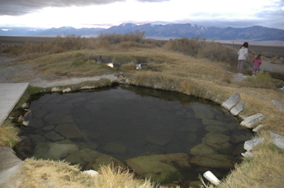
At Great Basin National Park I bought a book of natural hot springs in Nevada and California. We identified one in central Nevada, for which the directions go something like this: “Twelve miles east of Austin, turn south off US 50 to Rt 387. After one hundred yards, turn left onto an unmarked dirt road and proceed about 5.5 miles to a left. Turn here and continue about 3 miles to a fork, then bear right for another 1.6 miles.”
These directions brought us out into a place that is so far from ANYTHING that calling it the middle of nowhere would be a compliment. We are parked on a slight hill so that we can see clearly that there is hardly any sign of civilization for miles around. About 300 feet from our spot are three pools fed by a natural hot spring which bubbles from the earth at about 110 degrees. In other words, it’s perfect.
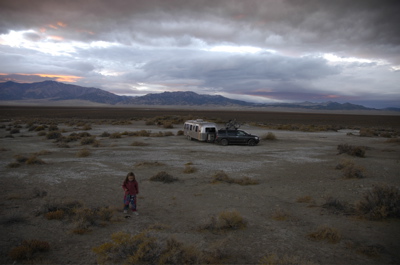
We arrived at sunset and I got these pictures. Of course the first thing we did after snapping a few shots was to throw on our swimsuits and drop into the second pool, which is lined with stones and runs about 100 degrees, or fifty degrees warmer than the air temperature. Ahhhhhhh”¦
We do have two neighbors. About ¼ mile to the north there is a large white “toy hauler” RV, and we’ve seen the occupants come by on their four-wheeler. They gave a friendly wave and disappeared. And a family showed up just after sunset with a couple of young kids to go swimming as well.
Tomorrow morning I plan to go for another swim in the mineral waters. And then, sadly, we’ll debark.
Misc note: a bag of potato chips exploded sometime while we were at high altitude. It might have been while at 11,000 ft on I-70. We had potato chips with dinner tonight.
November 5, 2005 at 8:33 am · Filed under Uncategorized
Here we are in Great Basin National Park and we have no idea what we are doing here. The sun is rising over my left shoulder (I’m sitting on the bed) as I write, illuminating the edge of a far-off mountain range like the great nuclear blast that it is. Emma and Eleanor are still sleeping. Just fifty feet from the bedroom window, Lehman Creek rushes noisily down the rocky slope on its way down from the small glacier above us on Wheeler Peak, 13,000 feet in altitude.
We are sitting in a lonely campground at 7,000 feet, in a lonely off-season (and little-known) National Park, off “America’s Loneliest Highway.” If you subscribe to Airstream Life you may recall the article by Bert Gildart, which appeared in our Fall 2004 issue. State Highway 50 across Nevada is our route for the next two days, through the most desolate and unpopular portions of the state ““ a place where signs saying “No Services Next 100 Miles” are a common sight.
We came to Great Basin in a dark moonless night. The tiny sliver of moon had set during our mad dash across the Utah salt flats last night, leaving us with only stars and the rare oncoming headlights. Imagine 80 miles with hardly a bend, no houses, no farms, no powerlines or cattle, or anything except the occasional dirt turnout, some scrub brush and off in the great distance a ridgeline that never seems to get closer. That was our evening. So watching the moon set was high entertainment during the drive. (At least we didn’t have to play “I Spy” for the two-millionth time.)
Arriving was a similar non-event. The park was dark, even though we had crossed into Pacific Time and locally it was only 6:30 pm. No ranger station, water turned off at all the campgrounds, visitor center dark, few signs (replaced with an ironic “signs down for maintenance” sign). We bumbled our way to Lower Lehman Creek campground and paid our $6 registration fee to the self-service kiosk, and picked the first site that seemed level. There’s no one else here.
Great Basin is notable for two things: Wheeler Peak, which we can climb, but probably won’t; and Lehman Cave. We may take the cave tour this morning before heading out. Not a long visit, but really Great Basin is only a stopover for us this time. Unfortunately we need to get to Nevada City by Sunday night, so I can catch up on some work projects.
—–
My laptop battery died just then “¦ so I took a walk outside to see the area. Surprise! Three tent campers are here with us, hardy souls indeed to have braved the clear night chill at 7,000 feet in November. Turning around, I was surprised to see a large male mule deer with a tremendous rack standing in my path. He gave me a look, and bounded off into the woods. They are not as tame as in Cherry Creek, I see. We’re not in suburbia anymore.
The surroundings are so different from where we woke up yesterday. Here, it looks more like New England. The mountains are covered in evergreens and, at the peak, snow. The air smells fragrant (odd for this time of year), and birds are chirping. A naked stand of white birch is across the cold creek. Quite a change from the red desert of Arches.
I plugged in the Honda generator and waited for 7 a.m. (generator hours) to fire it up and finish this blog entry. Eleanor and Emma are awake now, and Emma is being a slug in her bed, asking for someone to get with her and snuggle. As tempting as that is, we’re up now and I’m going to fire up some hot oatmeal and get ready to take the cave tour at 9 a.m. We’ll post this from the road later.
November 4, 2005 at 7:29 am · Filed under Places to go
Yesterday morning after I wrote the blog entry, I talked to our neighbors in the tent, a pair of women who run seminars and teach, from Massachusetts. One of them is considering a travel trailer and so she came over for a tour and a bit of hot water for her tea. By all reports, the wind overnight was a sleep-shattering experience for the tenters, as I suspected. Her decision to buy a trailer just got accelerated quite a bit, I think.
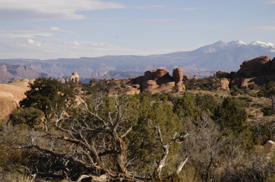
As I mentioned yesterday morning, the day started gray and not at all like the brilliant blue I associate with desert scenery. Still, the light was wonderful for detail photos of the rocks, plants, and wildlife, and so by 10:30 we were off on a 3-mile hike right from the campground to see a few arches.
Or so we thought ““ it turns out that while the park is named for the arches (and they are wonderful to see), they are only claiming top billing on the program. The vistas, wildlife, and unlikely rock formations are worth the trip even if you never saw an arch.
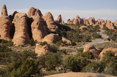
It is a testament to the beauty of this park that I ended up shooting nearly 200 photos in a single day, and after I reviewed them I kept about 140. The scenery is THAT good.
By the way, I have a new desktop wallpaper from one of yesterday’s photos. In a few days, you’ll find it in the Photo album, in the folder marked “Arches National Park”, called “Desktop”. If you like it you can use it as your desktop too. I’ll get many other photos up there soon also.
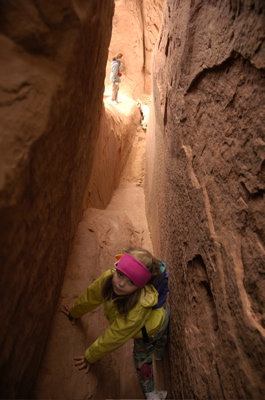
Here’s Emma climbing in one of the many little crevices. She loved the climbing!
By afternoon the sky abruptly cleared to the blue I wanted, which tended to wash out the rocks but offer opportunities for silhouettes and skylines. Emma was busy with her camera too, shooting at least a couple dozen photos. Suddenly the rocks were a lot more interesting to her!
The wind picked up to 20-30 MPH, and at one point near Sand Dune Arch we got sandblasted pretty heavily. The sand is very fine and gets everywhere, so I had to hide my camera under my jacket.
The first hike ended at about 1:30. We all got back completely worn out (and with sand in our hair). Either we’re badly out of shape, or the altitude (4,800) and dry air are really wearing us down. Still, the scenery was not to be missed, so after lunch and a little rest, we headed out again at 3:30 for an easy hike to Landscape Arch. We returned in time for sunset, having covered about 6 miles on foot for the day.
With the early sunset, the evenings have been long, so compensated by having a bit of a campfire & marshmallows, a movie ( “The Princess Bride”), and early bedtime. The wind rocked the trailer all night again (I’ve GOT to remember to put the stabilizers down next time!) but we slept like the rocks surrounding us.
We’ll be in Great Basin National Park the next night or two, so I’ll catch you up when I can …
November 3, 2005 at 8:14 am · Filed under Places to go
[I’m posting these next couple of entries at the time they would have been posted if we were online. For the last two days we’ve been visiting National Parks in Utah, well out of reach of the Internet, electrical power, and most cell phones.]
We left off coming from our evening campsite at Colorado River ““ Island Acres SP near Grand Junction, and I promised you some photos. Wow, did I get photos. Bright yellow aspens, variegated cliffs, the Colorado River running just a few feet from our door, and a beautiful park.
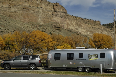
I would highly recommend Colorado River ““ Island Acres except for one thing: the park, a rail line, I-70, and the Colorado River are all squeezed into a small canyon in parallel. So freight trains run along the opposite side of the river at night (which doesn’t bother me, but some people can’t stand it), and the entire park is necessarily very close to I-70, which means a nearly constant rumble of highway traffic. With our windows closed against the 30-degree overnight temperatures, we didn’t notice the highway noise until the next morning.
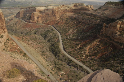
Not far away, on the other side of Grand Junction, is the Colorado National Monument. This park is basically a “Rim Road” which runs up, through, over (and sometimes under) magnificent canyons and bluffs for 19 miles, from east to west. The drive takes about an hour in a car. We had no idea what we were getting into until we arrived at the East Entrance, and then one quick look at the numerous switchbacks on the park map told us that the Rim Road was not a place to be towing a 30-foot Airstream.
So we took SR 340 to Fruita, where we went in the West Entrance. From that point it is still a harrowing climb up the canyon, but only four miles to the Visitor Center. We stopped at scenic viewpoints along the way, and were well-rewarded with views to the valley below at every turn. Built in the 1930s ostensibly for ranchers to use twice a year (but really a typical 1930s make-work project), the road is so unbelievable as to be a fantasy. In most places there are no guardrails or walls to protect the careless driver against a 500-foot sheer drop.
We also encountered two tunnels carved out of the red sandstone. At this time of year, traffic was so light that we were able to stop for a few minutes in each one and take pictures.

At the top was a campground and a smallish Visitor Center. We were tempted to stay the night but Arches National Park was calling us, and so we stayed only long enough to browse for books for Emma and renew our annual National Parks pass ($50, well worth it if you visit more than 3-4 National Parks per year).
Arches is, of course, spectacular. As a travel-hardened five-year-old, Emma was casual about the Utah scenery off I-70, not even looking up from her crayons as she muttered, “I know, more rocks. That’s all we’ve seen, is rocks, rocks, rocks!” But as we twisted through the 17-mile road to the center of Arches and Devil’s Garden campground, passing impossible red formations, even she had to admit they were impressive.
We drove in the park road at 4:30 pm yesterday, advised by the rangers that there was no way to know if there were empty spaces in the tiny 24-site campground at the end of the twisty 17-mile road. If we got there and the campground was full, we’d have to turn back, and by then it would be dark.
Fortunately a kind ranger gave us a special dispensation to park in the Group Camping spot if all other spots were full. So here we are, high atop a mesa with a spectacular 360-degree view. Later this morning we will have to move to one of the unoccupied spaces, when someone leaves. In the meantime, I think we will have oatmeal for breakfast, since the dawn has broken gray and cool and it promises to be a bit of a chilly day in the desert.
The wind rose up in the middle of the night and rocked the Airstream, and battered the tents camped nearby. I have suffered too many times from the fierce high desert winds at night, unable to sleep from the unstoppable flapping of the tent, and chilled to the bone. So I was glad to wake in the night and feel the gentle rocking of the trailer and hear the wind howling outside and know I would get up in the dawn well-refreshed rather than feeling as if I’d just survived an ordeal.
I was also glad to see Emma sleeping soundly in her bed. She is still sleeping as I type this but I know we will soon enough be out to hike a few of the many trails, and look for rabbits and other creatures that live here. She’ll have a full day.
By the way, Arches NP offers no hookups. For $10 per night, you get a place to park (if your rig is not too large: our 30-footer will only fit in about 1/3 of the sites), and the opportunity to fill up with water at the campground entrance. No dump station, no electricity, no Host this time of year, likewise no Evening Programs, and the distinct possibility of snow. We have been lucky in the snow department and for the rest we are fine with our Airstream and some imagination. One doesn’t really need an Evening Program here ““ the stars at night are spectacular and by the time of the 5:30 sunset we expect to be exhausted from hiking.
November 2, 2005 at 3:35 pm · Filed under Uncategorized
Quick entry: we’re at a lonely rest area off I-70 near Thompson UT, just taking a quick break. Amazingly Sprint has coverage here so our Internet in Motion box works and I’m taking the 5 minute opportunity to post a quick update.
We spent the morning at Colorado National Monument and took some AMAZING pictures, which I will post soon. What a beautiful place! Huge towering cliffs and red canyons, tunnels, and views that just blow your mind. We loved it.
But now we in Wiley Coyote country, heading into Arches NP (not Dead Horse SP, change of plans), and I don’t know if we can get online in the next two days. If you don’t hear from us for a bit, that’s why.
« Previous entries ·
Next entries »
