October 22, 2007 at 7:43 pm · Filed under Uncategorized
The forecast for the Hoh Rain Forest turned out to be just as ridiculous as I suspected. Partly cloudy? 61 degrees? I couldn’t see any difference between the rain of yesterday and the rain of today. Just as moderate, constant, and exactly the same upper-40s temperature. Not that I was disappointed, because it is after all a rain forest, but I was wondering how often such optimistic forecasts really come true up there.
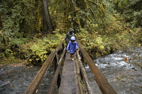
So we went for a hike in the forest. There are two short trails near the Visitor Center, running about 3/4 of a mile to 1.5 miles each. We took the longer one, but both Eleanor and I were wistfully eyeing the Hoh River Trail which goes 18.5 miles up to the Blue Glacier. In the summer that would be a heck of a great hike. We weren’t prepared for it on this visit, and conditions up above the rain would have prevented us from reaching the glacier anyway.
I can’t say enough about the beauty and dramatic forest scenery in the Hoh, but mostly because I haven’t time. This blog is coming to you from a parking lot in a small town near Cape Disappointment State Park, on the very lowest western corner of Washington State. This is the end of the Lewis and Clark expedition’s trail, and it’s also the site of a great state park where we are now camped. There’s no cell phone service in the campground at Cape Disappointment, so I have to commute a few miles into town to get online.
We had tried to make an intermediate stop at Kalaloch campground, on the coast in the Olympic National Park, but the weather was abominable. The campground was (predictably) completely vacant despite being located right on the water and having a beautiful setting. In the summer reservations are recommended, but now you can have your pick of sites.
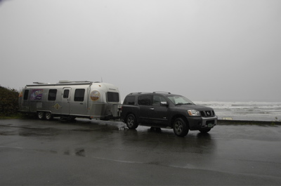
We were just a bit unlucky. When we arrived it was still raining, with huge sandy-brown waves crashing far out off the shore, and a cold wind. There was no electricity in the campground and no cell phone service. We stopped for lunch, parking the Airstream by the shore, and moved on.
The only other stop for the day was the tiny village of Humptulips, where we picked up mail. We chose this spot for our mail only because it was right on our route and had an interesting name. Picking up the mail forced us to stop and take a quick look at a place that we otherwise would not have bothered to visit. I may start picking other oddly-named little towns for our mail pickups in the future, just for fun.
Despite having difficulty getting online, we’ve decided to spend two nights at least here. There’s a lot to check out and it’s balmy (50s and 60s) and sunny. We need to soak up a little warmth and dry for a few days.
October 21, 2007 at 7:25 pm · Filed under Places to go
Normally I look for sunny weather, but if we had come to a rain forest (the first real rain forest we’ve camped in) and it had not been raining I would have been disappointed. I envisioned something primeval and dark, with moss hanging from everything, and a constant state of rain that fluctuated between drips from the giant tree leaves and steady showers.
So I have not been disappointed. The Hoh Valley is the perfect place to make rain. Moist Pacific air comes to land, carried by the “Westerlies” (an onshore breeze), and funnels into the Hoh Valley as it is pushed up by the rising landscape of the Olympic Mountain Range. Inevitably it cools and precipitates down to the giant trees that thrive in this mild wet spot, to the tune of 140 inches of rain each year. By comparison, our home base of southern Arizona gets only about a dozen inches of rain each year.
The Hoh Rain Forest will get 22-30 inches of rain this month, since we are approaching the really wet winter season. We drove through light to moderate showers for forty miles along Rt 101 and up the 20-mile Hoh Valley road, and as we approached the park interior the trees kept getting bigger and the forest grew more dramatic. The big leaves that cover the ground everywhere are from the appropriately-named “Big Leaf Maple” and they are often a foot wide. The moss finds purchase nearly everywhere, including trees, bridges, rocks, unused handrails “¦ any spot that is relatively undisturbed by the friction of feet, hooves, or water.
This time of year there are predictably few visitors, but I think this may be the best time to really experience the Hoh Rain Forest. It gets cold up above 3,500 feet, and snow is falling up there, but not here. The temperature has remained nearly constant at 47-52 degrees, a good temperature for hiking, and the air is still. Yesterday on the drive over we stopped to hike to Marymere Falls (an easy 1.5 mile roundtrip near Lake Crescent) and it was so comfortable that we spent most of the time in the forest studying the diversity of mushrooms and banana slugs that live in there, recycling the downed trees. Only near the falls, where a breeze was being generated, did it feel the slightest bit chilly.
Here in “the Hoh” they are predicting an unusual event for Monday, partly sunny skies and up to 61 degrees. I might even feel a little disappointed if it comes true. While we are here it may as well rain as much as possible, so we’ll never lose the sensation of being in the rain forest while we are camped.
 On the way here we passed one of Olympic’s record-setting giant trees. The moist climate allows Sitka Spruce to grow here, and there’s one near the road that is over 500 years old and 12 feet wide. Towering 270 feet straight up, it is impossible to photograph accurately. I have tried many times over the years to capture in a photo the sensation of standing beside a mammoth tree like this and each time I have failed. You really have to experience it yourself. It is an extraordinary thing, and even more thrilling when you realize that this country used to be covered in massive old-growth trees like this. Imagine walking through a forest filled with huge trees ranging from four to fifteen feet at their bases, and with the canopy 200-300 feet above your head. It’s kind of thing we only see in movies, or in those rare remaining spots where true old-growth forests still exist.
In the Visitor Center we bought Emma a little laminated booklet that helps identify animal tracks and scat. Right away we had opportunity to use it, because there are numerous piles of fresh scat only a few feet from our campsite, probably Elk.
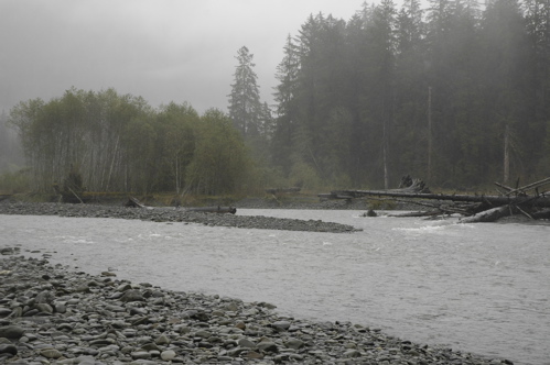
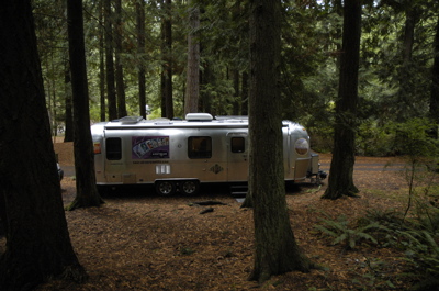
To one side of the Airstream is the rushing gray river, deep and fierce and wild-looking. It is bounded by fields of rounded rocks, tall pines and cedars, and dramatic valley landscape. To the other side we can see only trees disappearing into the fog, and above us there is an ever-present gray sky. Although the campground is quite civilized, and the water is never turned off here, there are only two other campers.
As you might expect, we are not getting much power from the solar panels. Not only is it constantly cloudy here, but tall trees shade every campsite, every parking spot, and even the road-side pull-outs. We voluntarily spent last night in the non-electric part of Salt Creek Recreation Area, but I mistakenly left the middle Fantastic Vent wide open all night, and as a result the furnace ran far too much. This used up 43% of our battery capacity in one night! (Have I mentioned lately how annoyed I am at the inefficiency of RV furnaces? I can’t wait to get that catalytic heater installed.) If we had the standard two batteries installed they would have been dead in the morning, but fortunately we’ve got four.
So we started off in Hoh with only about half our power bank remaining, and picked up virtually no solar power during the day on Sunday. Fortunately, the mild nights here mean that if I remember to close the vent tonight we will use much less power for the furnace. We should be fine for one more night before we head to the coast.
In any case, I’m not worrying about it. We watched a movie on the laptop and Eleanor and Emma baked an apple crisp using apples they’d picked from Janie’s tree in Montana. The trailer smells homey from the baked crisp, while the constant patter of rain on the aluminum is a reminder of the unusual place we’re in.
October 20, 2007 at 8:21 pm · Filed under Places to go
The knock on the door always seems to come at the worst time. Eleanor was in the shower, I was on the phone and still wearing pajamas, and our neighbors in the campground had come to visit. They were wonderful people, the Ritcheys, former Airstream owners and full of enthusiasm, and I can’t fault them for thinking we might be presentable at 10 a.m.
They live on the Olympic Peninsula, and having borrowed our open wi-fi signal and read the blog that said we were headed to the Peninsula, they felt it was only fair to return the favor of free Internet with some advice about where to go.
Eventually Eleanor and I got presentable — while talking — by sort of tag-teaming our guests. I managed to get dressed and brush my teeth while having a running conversation, and Eleanor picked up when I couldn’t.
This multi-tasking continued right up to the point when Eleanor went to dump the tanks. Naturally, the rest of us bunched up toward the hitch end of things, where I was about to demonstrate the process of connecting a Hensley. Just then, Eleanor reported in a distressed tone of voice (you’ll have to imagine it) that she had just had “a sewer accident”.
Since I am the primary tank-dumper in the family, Eleanor has never experienced the joy of a sewer malfunction. I am embarrassed to admit that my first reaction was to laugh. In this case, the sewer had backed up from the “full hookup” connection and overflowed onto the ground.
 Last night I reported that we had a full hookup at $21 in this campground, a bargain. But I didn’t actually connect things last night, Eleanor did. There was a cap with some writing on it. Eleanor glanced at this and saw the words, “Water,” “Sewer” and “ON” and assumed it was a sewer outlet.
Nope.
What it actually says is better revealed in the second photo, which shows the cap right-side up. This is in fact a cover for a valve to shut off the water supply in winter.
 Now, if I were the guy who had to shut off this water valve each season, I’d probably take much more aggressive steps to prevent people from accidentally confusing this with a sewer dump. Just one person, say for example a female person trying to help her husband and working in near-darkness, who finds this 4″ pipe that looks just like a sewer dump, in exactly the spot you’d expect to find a sewer dump, and who doesn’t carefully study the arcane inscription on the cap, and accidentally dumps a load of raw sewage down it … well, it certainly is a formula for ruining everyone’s day. The pipe is several feet deep and that’s a lot of you-know-what down the hole.
Well, let’s just cut to the conclusion. The situation was eventually cleaned up, mostly, and various people were cleaned up, and we fled, um, “departed” the campground for a very nice drive through Fidalgo and Whidbey islands. I don’t think Eleanor saw much during the first 15 minutes because she was liberally applying Purell to her hands and talking about how we were going to get a bill from the City for this episode.
I think in the course of driving through the islands for an hour we experienced half a dozen major weather shifts. Eventually we ended up on the M/V Klickitat, a ferry originally built in 1927, to Port Townsend.
Our friends from the campground steered us well. When we got to the Olympic National Park visitor center, we found that in addition to the seasonal campground closures that we knew about, two more campgrounds and a couple of roads were closed due to recent severe weather. This eliminated quite a bit of what we wanted to do on the first day in Olympic, so we decided to try one of the campgrounds suggested by the Ritcheys, Salt Creek Recreation Area (a county park).
Excellent find. This campground is right on the water, with most of the campsites just a few feet from a rocky bluff and an awesome view. There’s a water-electric hookup area, but it’s more sterile. Go to the no-hookup back loop (sites 59 and above) and you’re in the cedar forest. The sites are short but we managed to get the 30-foot Airstream parked without much trouble. A short hiking trail brings you to several beautiful overlooks, and at three points you can take stairs down to tide pools.
This campground was once a WWII gun emplacement, called Camp Hayden. The massive gun bunkers are still here and you can walk through them, along with some observation bunkers closer to the water. In fact, to go to the dump station you have to drive your RV through two of the bunkers! I’ll have to get a picture of that tomorrow, when we go dump … very carefully.
October 19, 2007 at 8:36 pm · Filed under Maintenance
Time seems to be passing very slowly in the northwet, um, I mean “northwest”. Has it been two days? Three? Is this a mild winter or a cold fall? I’ve lost track of time and season. The visual and climatological cues I’m accustomed to don’t seem to apply. Is the rain stopping or starting? Both, it seems, and at any time of day.
A friend asked me today if we were going to attempt to flee the rainy weather. Unfortunately we really can’t. The northwest rain extends down to northern California at present, and east to Montana. If we wanted to race 500 miles south we could but we’d miss all the great coastal camping along Washington and Oregon. Even in the winter, the state parks along that route have a great reputation.
We are taking an intermediate stop in the San Juan Islands before going to the Olympic Peninsula tomorrow. There are a lot of state parks in the islands worth visiting, but for convenience we chose a city park, Washington Park in Anacortes for a one-night stop (full water/electric hookup, $21). In the summer this place is reportedly very busy, but after Labor Day nobody seems to come here despite the mild weather. We are one of only four families camped here, so we had our pick of spots.
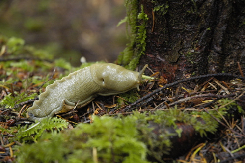
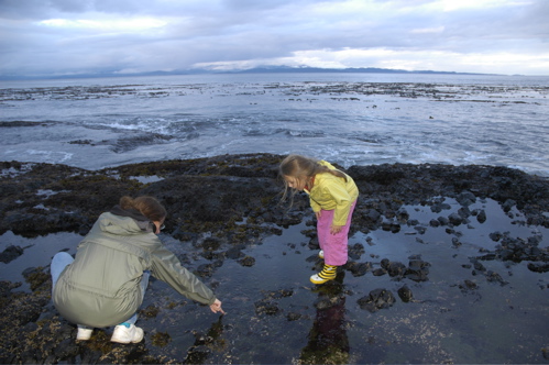
The park is heavily forested with what appear to be cedars and Ponderosa pines. It’s mossy, damp, dark, and it smells of aromatic trees and decaying vegetation. Within a minute of arriving Emma found a large green slug moving slowly across the forest floor, which is orange from the decaying cedar. That entertained her for quite a while.
A short walk from our campsite is a short stretch of shore and a dock looking out toward a cluster of other islands to the northwest. The water is calm, clear and cold, with only the occasional ferry meandering by. I can imagine how nice this place must be in the summer with all the shade. Even now it has a sort of rugged grandeur and peacefulness. If this were summer, we’d spend a week exploring the islands.
Although the campground has full hookups, I’ve learned that one can’t take voltage for granted. Not all 30-amp outlets are created equal. Last summer I bought a digital voltage monitor, which is plugged into an outlet in the bedroom, specifically so I could identify marginal campground electrical systems before they had a chance to cause us problems.
The air conditioner in our Airstream is also a heat pump, and we use it as our primary heat source when the temperatures are above freezing and we have 30-amp electric. But it doesn’t like low voltage, and Dometic specifically warns against using it below 103.5 volts. At that level, we’d risk burning out the motor. Without the voltmeter, there’s no way to know.
As it turns out, this is the first campground we’ve hit since we left Vermont that has serious problems with voltage. With nothing turned on, the meter shows the voltage at an acceptable 118 volts. When the heat pump kicks on, it drops to 106 and then stabilizes at 111. A strong electrical system wouldn’t do that. It’s marginal enough that we have to be careful to turn the heat pump off before using the microwave, otherwise the heat pump might try to start and drive the voltage below 104, which neither appliance likes.
 Maintenance has been on my mind lately. The Hensley hitch has been squeaking lately. That means the hitch ball needs lubrication. Normally you never see the hitch ball with a Hensley because it is permanently covered by the hitch head. To get to the ball, I leave the truck hitched up, loosen the weight bars and strut bars, and raise the trailer off the hitch head using the power jack.
This reveals the ball enough to lube it. I use Reese “On The Ball” hitch ball lubricant, which works well and doesn’t seem to attract dirt like grease does. Back down goes the hitch jack and the job is done for another year or so.
We were also overdue for an oil change for the Armada, which I got done at the local quick-oil place in Anacortes, and a pair of new wiper blades. The Armada will soon need its 60K major service interval and a set of tires, so I’m thinking ahead to cities in California where we may want to park for a few days and get all that done too.
Tomorrow’s plan is to ride the ferry to Port Townsend and eventually end up at Olympic National Park. It’s only 83 miles, so we’ll take our time and stop in a few towns. I don’t expect much cellular coverage once we get to the park, so the blog may drop out of sight over the weekend.
October 18, 2007 at 10:11 pm · Filed under Travel / lifestyle musings
I was well warned that the Pacific Northwest would be gray and rainy this time of year, so the weather we’ve driven into is no surprise at all. It has been raining almost continuously since we arrived on Tuesday and the forecast says to expect no sunshine until Sunday at the earliest.
But that’s OK for now. We are parked here to catch up on work and do a little planning for the future, not to play on the beach. This sort of pause in the action is a part of the full-time experience. We can’t take our next week for granted. We’ll wake up in the same bed for sure, but where will it be?
From the outside looking in, some people may assume we have a grandiose Master Plan which directs us. Others wonder, asking us, “How do you decide where to go?” The truth is that we have only the vaguest of Master Plans, and it is driven by basic influences, like the seasons. As I mentioned a couple of days ago, in the winter we have to stay south and below 6,000 feet. In the summer we head north and go visit family. Other than that, we consider things like upcoming holidays, business meetings, rallies, or interesting sights guide us. The school schedule is no longer an immediate factor since we plan to keep homeschooling for second grade.
For now, the season forces us west of the mountains, hugging the mild coast until we get into southern Oregon. We can only go south from here, and so that’s the plan: stay low and head south. But then there are details to work out. Thanksgiving is coming. Where will we spend it? We’ll need a full hookup for the actual day, since Eleanor will be doing massive cooking. I’ve been collecting ideas and talking to friends that we might meet.
Another example: I need to meet some people in California for future articles and business meetings. When will we be there, and where will we want to camp near major metros like San Francisco and Los Angeles?
And then there are the places we want to visit simply for the sake of visiting. Yosemite will be at the tail end of the season, but we might sneak in for a couple of nights. I’ve been wanting to have dim sum with Larry and Bill in San Diego. We’ve got friends in Oregon and California to catch up with. And we definitely want to spend a week or more in Anza Borrego.
We toss all these ideas, obligations, and wishes into a mental bag and let them all rattle around. Pauses like the one we have had over the past two days give us a chance to look inside the bag and put everything in order.
Practically speaking, it’s also a chance to spend a lot of time online researching. Sometimes you’ve just gotta surf for a few hours to figure out what’s ahead. Parks, campgrounds, scenery, weather, events, postal drops … all the info is out there if you go hunt it up. I make notes on alternative ideas, tell the Post Office where to forward our mail, and then hope for the best.
So we’ve done that and now I’m sick of the endless rain and sitting inside the trailer. On the San Juan Islands the forecast was for rain and 30-40 MPH winds with gusts to 60 MPH, so we stayed put. But tomorrow we are moving. I have the feeling that if I wait for a nice sunny day to tow we might be here all winter.
October 17, 2007 at 8:42 pm · Filed under Mobile technology
I’ll cut right to the chase here. We didn’t go anywhere today and the most exciting thing was having tuna fish on toast for lunch. So I’m going to take today’s blog to rant a bit.
Today’s Thesis: Campground wi-fi is about as reliable as Nigerian banker with $20 million to share.
It’s not usually the campground owner’s fault. Many of them got swept up into the promise that wi-fi would be a money-making service for them. They’d provide Internet service and charge $6 a day for it. A few still try to do it, but many of them have just opted to allow wi-fi for free, figuring it’s another marketing tool.
But getting wi-fi into RV’s all over a campground reliably is trickier than it looks. Geography, trees, buildings, and aluminum sided RVs all interfere with the signal. Electric motors, cordless phones, and other wi-fi installations also get in the way. Given that they are giving it away, not too many campground owners are inclined to make the level of investment that is needed to provide a good consistent signal. The result is that at most campgrounds we’ve visited that promise wi-fi, only about half actually provide a signal we can use inside the Airstream.
If you can’t receive the signal indoors, it’s not very useful. In Oregon near Crater Lake National Park, I remember a park where the wi-fi was reachable only within a few feet of the office. I had to sit at a picnic table outdoors with mosquitoes chewing on me. If it’s not mosquitoes, it’s cold temperatures (try typing with frozen fingers!), wind, sun so bright you can’t see the screen, or rain. It’s rarely nice enough outside to work on a laptop.
Then it gets worse. The routers and cable/DSL modems commonly used occasionally have problems, caused by power outages, spikes, people tripping over the wires, etc. They often need to be re-set, but usually nobody in the management office knows how — or even is aware that something is wrong. So even when we find a signal, I often find something technical is wrong. The router may not be assigning IP addresses, for example.
A typical scenario is that the wi-fi works for a few hours, but then suddenly stops for no apparent reason. Sometimes it comes back, usually it doesn’t. When I tell the folks in the office, I usually get a panicked look and then some gobbledygook like, “I think the Internet is down,” or “I’ll have to ask Tony when he gets back next week.”
Sometimes they’ll give up and let me take a look at the system. I’ve lost count of the number of times I’ve found myself on my hands and knees underneath someone’s desk sorting out dusty wires. Usually it’s a matter of tracing the power cables, discreetly pulling them out (because the staff gets nervous when things are disconnected, even for a moment), and reconnecting them in the proper order.
This is why, when I am told by prospective travelers that they intend to seek out “wi-fi campgrounds”, I ask if they really need to get online. If you intend to rely on the Internet as you travel for information and communications, don’t expect wi-fi in the campgrounds to work more than 50% of the time. Really, it’s that bad.
If intermittent and unpredictable access to the Internet is OK with you, then you’ll be happy. If not, you’ll need to consider either a cellular Internet card (Verizon, Sprint, AT&T/Cingular, and Alltel offer them), or a satellite Internet dish. I’ve talked about these options before in the blog, so if you are curious, just do a search on our archives.
I don’t have a lot of hope that the bad state of campground wi-fi will improve any time soon. The cost of putting in a real commercial-grade service is beyond most campground owners. For those who regard Internet service as essential as oxygen and drinkable water, expect to “bring your own” for the next decade or so.
October 16, 2007 at 7:01 pm · Filed under Travel / lifestyle musings
Our attempt to spend a few days in Vancouver was stymied by circumstance. I needed a campground with wi-fi available, to catch up on work, but I hadn’t thought to research it before we went into Canada. Once we got to the Vancouver area, it was raining (of course, because that’s what happens in the Pacific Northwest in the winter), traffic was heavy, and we had no clue where to find an appropriate campground.
After meandering aimlessly through Surrey for a while, and having lunch in a parking lot, we decided to head back across the border so that I could catch up on work with my Verizon card and phone, and skip Vancouver this time.
 The good news is that we are safely on the Pacific coast. We got past the final barricade of mountains along Route 5 in British Columbia without incident. Although the weather will probably be rainy here on the coast whenever it isn’t foggy, it will mostly be mild. For example, the weather forecast for Birch Bay (about 100 miles north of Seattle) is virtually the same for every day this week: highs in the 50s, lows in the 40s, and a high probability of rain. Beats snow.
So we can take our time from here. We’re no longer racing against the calendar. Our only scheduled obligation is to meet some friends for Thanksgiving in southern California, and even that plan is still tentative. Worst case, we have a month to drive 1,250 miles through Washington, Oregon, and California. That’s my kind of schedule.
The current discussion is whether we want to return to home base for Christmas. Eleanor and I had another one of those early morning discussions in bed about it. No conclusions yet. We have several possibilities and considerations which make it a tougher decision than you might think.
For one thing, in December RV’ers have a limited range of destinations. For decent weather out west and no risk of snow, we’ve got the valleys of California and Nevada (San Joaquin, Death Valley, and Owens Valley), the Pacific coast, southern Arizona, southern New Mexico, southwest Texas, and Mexico. Any place over 4,000 feet is suspect. Anything over 6,000 feet is very risky. That rules out the entire Colorado Plateau, and most of the western national parks, for examples.
But this is a fun problem to have. We’ll continue to mull it over as we cruise the coastline, and by the time we get to the San Joaquin Valley I’m sure we’ll have something figured out. In the meantime, the next stop will be in the San Juan Islands for a few days, and then over to Olympic National Park this weekend.
Our location: 48 °55’7.11″N, 122 °44’17.03″W
« Previous entries ·
Next entries »
