Archive for Places to go
September 3, 2008 at 7:34 pm · Filed under Places to go
This is already an amazingly great National Park and we’ve only been here a few hours.
If you were looking for the middle of nowhere, Hovenweep is pretty close. The nearest town (fuel, services, food, etc) is Cortez, about 44 miles away via a bumpy County Road. The park is in the midst of vast tracts of open desert. Almost nobody lives in the area. There are few roads.
And yet, when we pulled in, we were blown away to find a completely modern, accessible, and handsome Visitor Center, and just beyond it, one of the most beautiful campgrounds we’ve ever seen. I mean, it’s the nicest place we’ve camped since Frisco campground in the Outer Banks. And best of all, there’s nobody here.
 I mean nobody. In the 30 site campground, there is one camper: ours, shining brilliantly in the desert sun in space #4 with a gorgeous view in all direction. In the Visitor Center, there are two rangers and nobody else, so we got extremely personalized service at the desk. On the Ruins Trail that we hiked this afternoon (2.0 miles), we saw two people who quickly disappeared, and other than that we had the place to ourselves.
And the kicker is that for some strange reason, there’s a cellular signal here. There’s not supposed to be. I’m supposed to be offline, disconnected from the Internet. And yet, when the winds blows right and I hold my breath, I can get a cell phone signal.
This changes everything. We no longer have to rocket through this park and Natural Bridges (our next stop) because work is piling up. We can take our time, because every morning and evening I can get online and keep up with business.
When the stars are telling you something, you’ve got to listen. It’s $10 a night to stay here, the weather forecast is for sunny mid-80s all week, we have a gorgeous spot and our water tank is full. It all adds up to: “STAY”. So we’ll stay for at least two nights and then decide if we want to move on.
It seems almost unfair that we should have all this to ourselves, but I’m not complaining. The ancient ruins all around here are fascinating, Emma’s doing another Junior Ranger program, we’re luxuriating in the dry air, and there’s plenty to do in the area. This is the type of situation that we live for. It makes all those Wal-Mart nights and borderline campgrounds and high fuel prices worthwhile. May as well enjoy it.
September 2, 2008 at 4:57 pm · Filed under Places to go
Our plan for the day was to explore a representative sample of Mesa Verde, not everything. A park this size can’t be seen in one day, in fact it probably can’t all be seen in a week if you count in all the hiking trails. For our first visit to a big park we like to sample and browse, and in the process learn what we’ll want to come back to see next time.
 I’m a big advocate of the idea of hiking a park as much as possible. I realize that’s not possible for everyone, but right now it works for us and so we always try to check out the lesser-known corners by making the effort to hike. Our first hike was an easy one, the Farming Terrace Trail near Cedar Tree Tower, about 0.5 miles. The Ancestral Puebloans who lived here during the time of cliff dwellings were farmers. They grew squash and other vegetables, including a very small variety of corn. Since rainwater runs off the mesas very quickly, they created small terraces to slow the water enough to irrigate their crops. This trail brings you right through a series of terraces.
Three of the most popular cliff dwellings are only accessible by guided tour ($3 per person). We’d seen Long House yesterday, so today we had tickets for Cliff Palace and Balcony House. As it turned out, this was a great order to see them in. Long House is a spectacular first dwelling to tour (150 rooms), and then Cliff Palace is even more elaborate (151 rooms), so you can easily see the difference.
 Visiting these dwellings requires climbing ladders and going up and down irregular stairs. The Park Service warns people about the physical challenges of these places, and in the pre-tour briefing the rangers all mention that, should you have a medical emergency, help is three hours away. In reality they aren’t particularly strenuous to anyone in good health, but you can see why the rangers prefer to scare away anyone who might have a problem: They are the ones who will have to carry the stretcher up and out of the canyon.
 Something special was happening at Cliff Palace when the Puebloans lived here. It has many more kivas (round ceremonial rooms built into the ground), plastered walls, excellent masonry work, and elaborate decorations. It’s anyone’s guess as to what made this particular so much more elaborate than all the others.
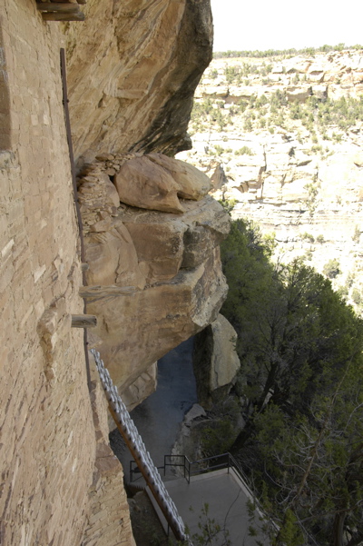
Balcony House made a fantastic final tour. Fair warning: this tour is not for anyone with a fear of heights or claustrophobia. It is considerably more psychologically challenging than the other two. The tour starts with a pair of 30-foot ladders mounted on the cliff above a very very long drop. “Don’t look down — don’t look up!” warns the ranger. “Just look straight ahead and keep three points of contact on the ladder at all times.” I didn’t look down, but I did look up and regretted it.
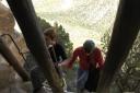
Climbing the ladder at Balcony House — click for larger
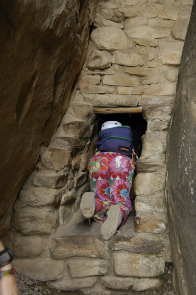
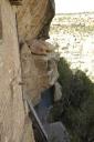
Once you’re inside the Balcony House, the view is stunning and you can see why it has that name. You also might wonder how the heck you’re going to get out of there. Back down that ladder? No, it’s even more interesting. You crawl through a tunnel that is 18″ high, and twelve feet long. (In the middle it opens up enough to crouch, but that’s all.) Emma made it look easy. The rest of us took off our packs and pushed them ahead of us.


Emma goes in the entrance; a tourist comes out the (larger) exit.
Then, you climb up a sheer rock face with chain-link handrails. Again, looking down is not recommended. It’s a looooong way to the bottom of the canyon.
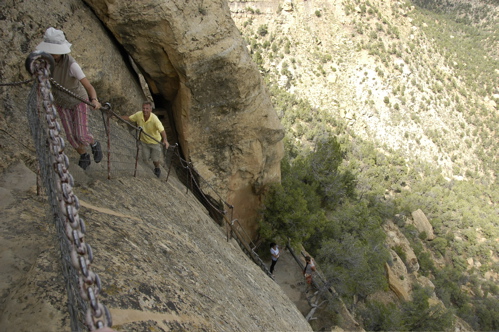
Last challenge of Balcony House — click for larger view
If climbing ladders isn’t your thing, you can still see a lot of cliff dwelling sites from your car, or on a hike. Many are marked from overlooks, and a few others are just surprises. Just by keeping my eyes open during drives and hikes, I managed to spot and photograph more than a dozen cliff dwellings. The Spruce Tree House is probably the best self-guided tour, and it’s only a few hundred feet via paved walkway from the Chapin Mesa Museum parking lot.
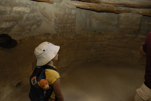
At Spruce Tree House you can actually get in a restored kiva. Kivas had roofs made of wood, but the wood has long since rotted away, so during the guided tours you see right into the kiva, like looking at a foundation with no house on it. But getting into the kiva at Spruce Tree gives you a sense of the mysterious, and you can imagine the rituals going on inside while the ceremonial fire burned.
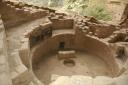

Kiva without roof; inside a kiva
From Spruce Tree house there is a very nice hike on the Petroglyph Point Trail. The signs claim that the total elevation gain is only 174 feet, but that doesn’t include the many ups and downs in the trail. In reality, I would estimate the total climb at several hundred feet — all at about 7500 feet elevation, in arid and often hot conditions. Bring a lot of water. The reward is not only some superb petroglyphs but an unnamed cliff dwelling along the trail. If you want to just see the petroglyphs with minimal effort, do the trail backwards (it’s a 2.8 mile loop), and turn around when you reach the petroglyphs. The second half of the trail is on flat mesa, very easy.
All this plus a short visit to the Chapin Museum accounted for a full day. Our last stop was for fuel, but as I expected the concessionaire-run gas station at Morefield Campground was outrageous. Unleaded: $4.71 per gallon. Seven miles away in Cortez, gas is $3.83. This is typical. When the concessionaires run things, there are more services in the parks but they always cost an arm and a leg. This also accounts for the campsites costing $24.05 instead of $14. I bought two gallons of gas just so we’d have a reserve to drive to Cortez for a proper refill.
Our stop today is Cortez, CO, to top off our reserves. We needed an oil change, a tank of propane, gas, groceries, a fridge defrost, and a chance to catch up on email & the blog before heading out again. The next four days of travel (at least) will involve places in Utah where the cell phone won’t work, Internet is just a concept, groceries are scarce, and prices for everything are likely to be high. I can’t say when I’ll get a chance to update the blog, but I will keep writing entries as we travel, and upload them as soon as possible.
August 30, 2008 at 12:30 am · Filed under Places to go

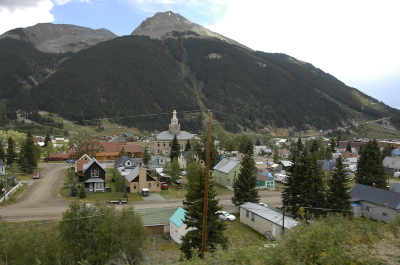
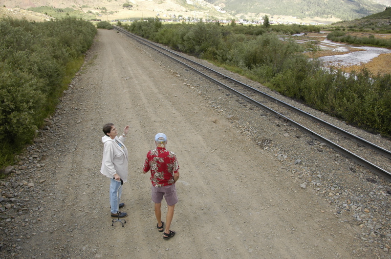
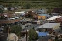
From our campsite in Silverton, “it’s up, to anywhere,” according to Mike. That’s because we are sitting in the small valley ringed by mountains of 11,000 to 12,000 feet. It may look like we are in the lowlands, but our elevation is still high enough to mess with the cooking (9,400 feet). We parked are in the middle of a flat spot just big enough for the tiny town of Silverton, a narrow-gauge railway, a river, and not much else.
If nothing else, the air would tell me that we are at high altitude. When the sun is shining through the thin atmosphere, it feels very warm, but the moment it ducks behind a cloud there’s a chill. Nighttime low temperatures are in the 30s right now, and sunlight is limited by the high mountains. In the winter, Mike says, the sun rises twice: shortly after coming up it slides behind a mountain and comes out again later.
Everything around the Airstream says we’re in an old western mining town. There are rusty metal pieces and concrete foundations left behind by miners, and mountains scarred from tailings and avalanches. The main street has old hotels and the remains of a once-thriving “red light” district. There is no consistency in architecture, and no sense of enforced historic preservation. The mere fact of utility has kept buildings in place: if it hasn’t burned down or collapsed under the snow load, why change it? We certainly aren’t in Telluride.

Silverton has two paved roads. One is the highway that brought us here, and which continues on to Ouray. The other is the main street of town, where we are parked. When the snow is deep, snowmobiles are the fastest way to get around.
It’s a relatively quiet main street because it doesn’t go anywhere. At one time the locals had a sign at the end of the street that said something like, “This isn’t the way to Ouray.” Lost tourists have to make a U-turn. The rest of the streets are dirt, giving the town a very western rural look.

This morning Mike took us on a tour of the area in his 4WD Isuzu Trooper. Seeing town doesn’t take long, but as with all the funky western towns, there are lots of little details hidden in the corners and stories to be told about the people and events that make the town interesting. And it is a very small town: the local school had 40 students (including grade school and high school) and a graduating class of 1 last year. So everyone seems to know everyone else, and if they don’t, they wave anyway.


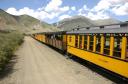
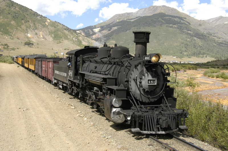
There’s a narrow-gauge railroad that runs from Durango to Silverton, along approximately the same route that we just towed on Thursday. The train comes into Silverton twice a day, so we went over to watch it go by. I’d be tempted by the ride, but it takes several hours to make the round-trip, and the drive over is still too fresh in my mind.
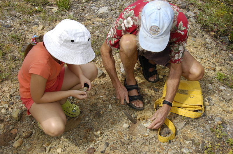
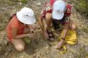
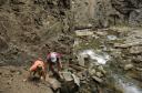
Being a dyed-in-the-wool rockhound, Mike knows all the spots to find various minerals. He also knows Emma loves hunting for rocks, so a large part of our tour involved stopping at old mining sites and whacking rocks with hammers. They found some big pieces of rhodonite, but struck out on finding a good sample of “peacock copper.” It wasn’t all rocks, though. Mike was good enough to give a fair bit of mining and settlement history as we walked around the ruins of stamp mills and narrow gauge railways.
We like Silverton, so we’ve decided to postpone our departure by another day. We’ll spend Saturday much as we did today, just looking around and maybe doing some small hikes, before moving on to Mesa Verde.
August 28, 2008 at 10:26 am · Filed under Places to go
Coming to high altitude areas and hiking requires some acclimation. Normally we are above 5000 feet for at least a few weeks before we attempt hiking in the mountains, but this time it didn’t work out that way. So when we started climbing up giant sand dunes in the morning, it was more of a challenge than you’d think.
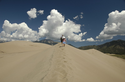
The dunes are mammoth, with the big ones running 600-750 feet tall. The big ones are surrounded by foothills of sand, so at first the climbing doesn’t seem that bad. But being made of shifting sand, there is no trail, and it’s easy to summit a sandy peak only to find that a massive canyon lies between you and the next dune.  After about 90 minutes of zig-zagging across the steep slopes, we finally reached the top of one of the higher dunes, and stopped for a snack, some oxygen, and a quiet look at the gorgeous view.
Hiking in the dunes can be extremely arduous and even dangerous under some conditions. Summer temperatures on the dunes can reach 140 degrees, and thunderstorms are common. If you’re on the dunes during lightning, you may have a bad day ““ and it’s hard to escape quickly. For these reasons we went out in the morning, and were lucky enough to enjoy absolutely spectacular weather and crystal visibility.
 Water and sunscreen are the other keys. It’s like being on a sunny beach, only with no shoreline. Bring a lot of water on a warm day. Don’t be fooled by the green pines that cover the mountains. The dunes are a desert environment. I filled my 100-oz Camelbak and the three of us drained it in about three hours, plus some additional 16-oz bottles. The problem with the sunscreen is that the sand sticks to it, but there’s no point in worrying about that. You’ll come out of the dunes with sand in every possible location anyway.
While it hasn’t been extremely hot, we took the middle of the day off from hiking and stretched out in the Airstream. Like other western parks, there are higher altitude spots to go when the heat is oppressive. In the afternoon we chose Zapata Falls (just outside the park entrance). To get there, you drive up a winding rocky road to a trailhead at about 9000 ft, then hike up further on a half mile trail to a refreshing mountain creek in the trees.
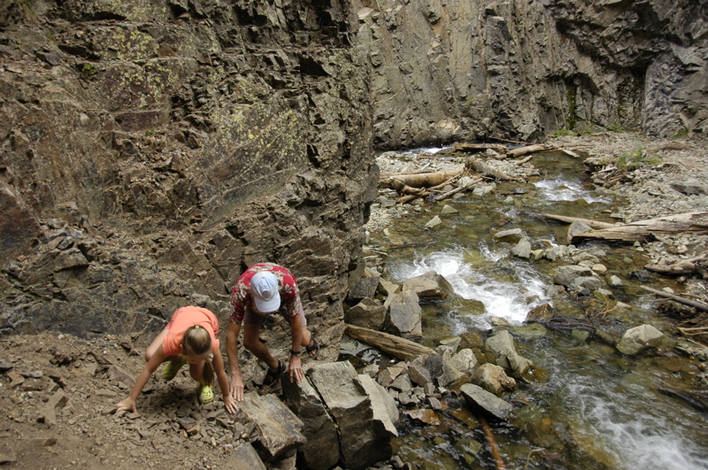
 This is where it gets interesting. Zapata Falls are inside a very narrow gorge, and the only way to see the falls is to hike upstream a short distance through icy cold water. The creek narrows to a slot in the rock, and after passing through that you can glimpse the water falling. Since you do this while standing in calf-deep water that makes your feet go numb, the visit is brief. But it’s worth the trip. The hike also offers some nice views of the Dunes from above.
As a wind-down, we drove down the Medano Primitive Road in the park to get a different perspective on the dunes. Ordinary cars can traverse the first mile of the road, but then it becomes 4WD only. If you want a long 4WD adventure, you can go 12 miles all the way up to a mountain pass above 9000 ft and then hike another 1900 feet of elevation to a lake. That’s one I’d like to try.
The hiking here has been great, and if we had another full day we’d take one of the longer alpine trails up into the Sangre de Cristo Range. Despite the challenge of acclimating to steep hikes about 9000 feet, we all really like this park. I think we will come back.
August 27, 2008 at 10:06 am · Filed under Places to go
As national parks go, Great Sand Dunes may be underrated. We had put it on our itinerary as a side trip from the drive across southern Colorado, figuring that it would be one of those parks that has one predominant feature and not much else. After all, it’s just a bunch of big piles of sand, right?
Turns out there’s a lot more here than that. Yes, there are enormous sand dunes, up to 750 feet tall, in a huge field just a short hike from the campground. But being bordered by both desert and the tall Sangre de Cristo mountain range, the environment is very diverse and there’s a lot to see, and a lot of great hiking.
 We weren’t sure when we arrived if we could actually camp in the park. The sites are generally short, meaning better suited to tents and small RVs. Big motorhomes have to camp at the Oasis Motel & RV Park just outside the park entrance. But most of the national park campground was vacant when we arrived, and eventually we shoehorned the Airstream and the Nissan into one of the larger spaces. The site slopes upward a lot, and the trailer definitely a bit higher on the front end, but it’s comfortable enough and the view of the dunes is spectacular. (No hookups, dump station, $14.) Plus we can hike to the dunes right from the Airstream’s door.
The geology of the dunes is interesting. The park has an very good Visitor Center, where you discover how the sand blows in from the San Juan Mountains to the west, drains down in creeks from the east, and then gets trapped here at the foothills. Two creeks circle the dunes, picking up any “escaped” sand and dragging it to the southwest side, where the winds redeposit it on the dune field.
Always eager to hear it from directly from the Rangers, we went to a scheduled sunset walk on the Wellington Ditch Trail, but there were thunderstorms in the area and the Ranger never showed up. Since the storms were heading away (all we got was about one minute of pea-sized hail), we hiked the trail ourselves, and then dropped in to the amphitheater for an 8:15 Ranger talk.
 The wildlife here is also interesting. Down in the dunes there are species that only exist here, such as the Great Sand Dunes Tiger Beetle, and through the foothills and lower alpine area there are black bears (bear-proof food boxes are in every campsite), deer and mountain lions. A black bear was spotted in the afternoon crossing the road between the campground and Visitor Center. On the other side of the dunes, the Nature Conservancy manages a herd of over 1,000 buffalo.
Up in the alpine areas there are marmots, bighorn sheep, and pikas, plus a very unusual salamander that actually survives the high-altitude winter by allowing itself to be frozen. The Ranger at the amphitheater talk had one and Emma was thrilled to hold the 7-inch creature in her hands (with gloves, since skin oils are toxic to the salamander).
The park was expanded in 2000 to include a chunk of the Sangre de Cristo range, which protects some of the area that contributes to the dune (adding, “and Preserve” to the official name). This expansion gives the park an enormous added dimension of mountain hikes and 4WD roads, which is what gives it a much greater status in my opinion.
With that addition, the park is more than just a place to hike around on some big sand dunes. There are some really impressive hikes up to high altitude, both easy and hard to complete. You can drive up from the base elevation of about 8400 feet, where we are camped, to mountain passes at 9900 feet, and then hike 2000 feet further up to a mountain lake, or you can just start hiking from several other points and get great views of the dunes without a lot of elevation gain.

At this point we have already decided to extend our one-night stay to two nights. It would be easy to stay here for several days or a week if we were going to tackle some of the big hikes, but I am under work pressure and need to get to a place where I can get online a little better for a few days. Cellular Internet works here, amazingly, but slowly. Two nights will have to do, and I’ll make a note that the next time we come to Great Sand Dunes, we should bring full backpacking gear for a few days of hiking.
August 20, 2008 at 12:31 am · Filed under Places to go
Our big trip for today was out to Wheat Ridge, CO, where Timeless Travel Trailers is based. They’re a relatively new advertiser in Airstream Life magazine, and Brett and I wanted to check out the operation. We’d heard very good things about them from the Airstream folks in Jackson Center.
 We were extremely impressed. They’ve got 30 people working in two buildings, cranking out two completed trailer projects each month. The staff includes two full-time designers, an estimator, and a couple dozen craftsmen in various specialty areas. The head of the operation, Brett Hall, gave us a tour of the facility and then sat down with us over lunch to talk about the industry.
TTT is on the way to becoming the official builder of custom Airstreams. Right now, Airstream doesn’t normally sell trailer shells, for lots of reasons. TTT has been allowed to buy a few direct from the factory for customization, and if all goes well they’ll formalize the relationship with Airstream and be the only shop in the country allowed to build custom Airstreams from new shells. The photo at left shows a new 31 foot Airstream shell in which TTT staff have begun to run wiring for a client.
 TTT also rebuilds vintage and late model Airstreams for customers. There were about six projects in the shop when we arrived, each one being renovated at a fantastic pace. The 34-footer in the photo at right as been in the shop for five weeks and will be done in one more week. The customizations run from about $50,000 up, with many projects exceeding $100k.
I love visiting my advertising clients because they all have interesting stories to tell, and interesting businesses. In the past week we’ve been to see Airstream, Bill Thomas Camper Sales, and Timeless Travel Trailers. All of them have been completely different, but share a common excitement for the product and the lifestyle it enables.
This evening’s entertainment was bowling downtown at Lucky Strike Lanes with Brett G’s sister, who lives in Denver. Emma loves bowling, and it seems to be something everyone can enjoy, even the lousy players. (Tonight I was the lousy player for some reason.)
Brett G is spending the next couple of nights at his sister’s house, so our Airstream is a bit emptier than it has been lately. We’re gearing up to get back into our usual 3-person travel mode. I’ve finally made plans for our weekend (Colorado Springs), and we have a tentative plan for the next couple of weeks. Thanks to everyone who suggested their favorite national park in Utah — we plan to take that advice soon.
August 9, 2008 at 10:04 pm · Filed under Places to go, Roadtrips
From Penn Wood to our next visit was only a three hour drive along I-80, through the alternating rainshowers and sunshine that I’ve begun to accept as normal. As roadtrips go, it was unexciting but at least convenient: straight down the highway and no need for fuel stops along the way.
I was surprised to find that I-80 passes right through a national park I’d never heard of: Cuyahoga National Park. If I’d seen this during research we would have tried to fit it into our schedule. The park doesn’t have camping but it does have two visitor centers (which means it likely also has a Jr. Ranger program). I made a note for next time. We seem to get through Ohio at least once a year, and visiting our friends Lou and Larry has become part of a regular routine as we head west.
So that’s where we are: parked in “our” spot alongside their house, with an extremely convenient full hookup. (I suspect they let other people use our spot when we aren’t here, but they haven’t admitted it yet.) Unfortunately, Lou and Larry had a family gathering to attend on Saturday, which drastically curtailed our visiting time. We spent the morning with their daughter Loren touring downtown Oberlin instead.
Oberlin, beside being known for its downtown college, takes some pride in the fact that it was a key junction of the famous “underground railroad” which protected escaped slaves in the mid-1800s. The sculpture above, which is visible on South Professor Street, symbolizes that historical role. All students have been welcomed to Oberlin College regardless of race since 1835. In 1858 town residents rescued an escaped slave who had been taken by “slave catchers.” This incident, documented here and in many other places, is claimed to have sparked the Civil War.
This evening the thunderstorms returned, thus maintaining the streak of having no more than 24 hours without rain in the past couple of weeks. Ohio has not been exempt from the exceptionally wet summer this year. Around town we can see how the corn is coming in spotty due to being drowned by rain, but it isn’t half as bad here as it is back in New England. We’re getting calls from people back in Vermont who are wondering when the rain and gloom will stop. From the weather map, it doesn’t look like things will improve much anytime soon.
All this rain has made me extremely glad I went to Colin’s shop for a leak test last month. It only takes a little while for a leak to cause major damage to the subfloor (and in turn, structural integrity) of an Airstream. One of the leaks that were found in that visit was letting in a surprising amount of water. I made a video which explains where the leak was, if you’re curious. Also, the repair to our front compartment that we received at Colonial Airstream in May, has been tested and proven good. We’ve towed through several heavy downpours and the front compartment has remained absolutely dry.
We’ll be at the Airstream factory in Jackson Center OH for several days this week, starting tomorrow night. A couple of friends have called to say they might be there too, which I’m hoping for. Jackson Center is a very small town with not a lot going on, but we usually manage to have a good time when friends show up in the Terra Port. Perhaps we’ll get really lucky and it won’t rain, too.
« Previous entries ·
Next entries »
 I mean nobody. In the 30 site campground, there is one camper: ours, shining brilliantly in the desert sun in space #4 with a gorgeous view in all direction. In the Visitor Center, there are two rangers and nobody else, so we got extremely personalized service at the desk. On the Ruins Trail that we hiked this afternoon (2.0 miles), we saw two people who quickly disappeared, and other than that we had the place to ourselves.