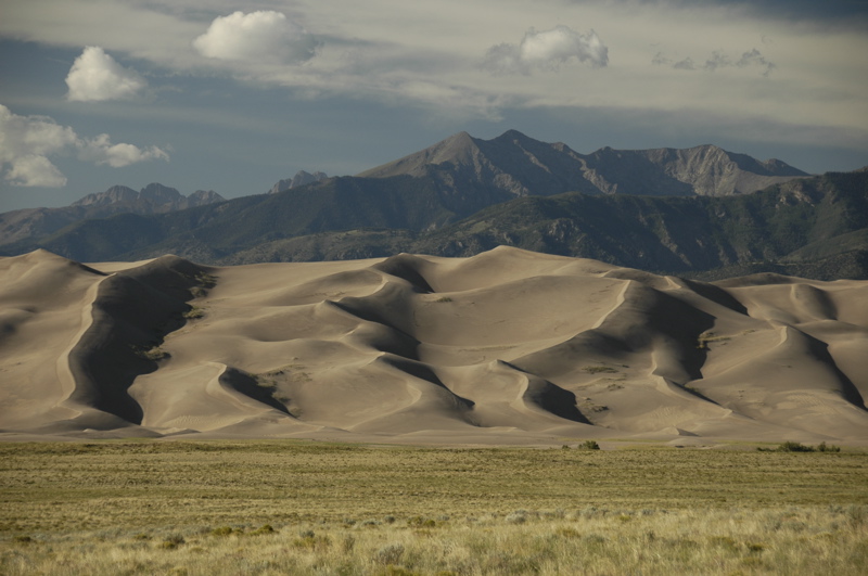
We have departed the Great Sand Dunes for points west.
This has been an incredibly convenient park. Near the campground they not only have a recycling center, a bear-proof trash drop-off, a dump station, and good-tasting water, but also compressed air. It’s provided for people who have had to lower their tire pressure when driving on the sandy 4WD roads. I took the opportunity to get all of the trailer’s tires to exactly 65 psi cold, and then we headed over to the Visitor Center to show the rangers Emma’s efforts in the Junior Ranger booklet.
 The rangers were suitably impressed with her work and her drawing of the dunes, and the fact that she had been in the park for three days. So they awarded the ultimate bonus of the Junior Ranger program: both a badge and a patch.
Our goal for the day was Silverton, where our friends Mike and Tracy live. It’s not on the way to anything we had planned to see, but the opportunity to enjoy their hospitality and local guidance was worth wandering 50 miles off course.
Driving around Colorado means you’ll eventually have to cross a mountain pass. The big ones all have names, and you’ll remember them, because each pass has its own personality. They vary in steepness, length, height, and fear factor, but they are all memorable.
In our travels we have crossed some doozies. Slumgullion Pass on the road between Durango and Creede was really a nail-biter. Monarch Pass was memorable for the aerial tramway we rode at the 11,000 foot summit. At those altitudes the gas-powered Nissan doesn’t put out its full power, so we generally gear down to 2nd and roll up the mountain grades at 35 to 40 MPH. That’s fine, since the speed limits on the twisting state highways leading toward passes are usually about 45 MPH, and slower in the hairpin curves.
Today we set a record: three passes in one trip segment. The first was Wolf Creek Pass, about 9,400 feet. The second was Coal Bank Pass, at 10,600 feet, and the third (right on the heels of Coal Bank) was Molas Pass at 10,800 feet. At Molas the summit feels like you’re on the top of the world. Ten thousand foot peaks are scattered around below you, and vast deep valleys are far below.
Of course, what goes up must go down, and that means four or five miles of 7-8% descent. That’s enough to smoke your brakes if you aren’t careful. Our procedure has been to keep the truck in 2nd and tap the disc brakes once in a while to keep the speed under 40 MPH, and 25 MPH in the curves.
Coal Bank is right up there with Slumgullion for sheer terror. Much of the road involves incredibly long drops off the non-existent shoulder, and there are few guard rails. Cross the white line with a wheel and it will be the last thing you do. I kept my eyes focused on the road and tried not to look down the steep embankments, although Eleanor was right there with a running commentary about the cliffs.
After that experience, we were glad to wind down into the little former mining town of Silverton, where Mike and Tracy live part of the year in a little century-old house on the main street of town. (When they are not here, they’re off in their Airstream Classic motorhome, which for the record goes up Coal Bank Pass at about 20 MPH. Mike says, “I’m the guy I used to be stuck behind when I was younger.”)
We’ve been given a fine courtesy parking spot next to the house, and an invitation to stay up to 20 days, the legal limit here. We’ll probably stay two or three days, although I could certainly yield to the temptation to stay longer. Even with only a couple of hours before sunset, I could see that Silverton has a lot of things to explore: historic architecture, hummingbirds, hiking, 4WD explorations, abandoned mines, local characters, etc. We’ll start checking it all out on Friday.
