April 20, 2008 at 8:39 pm · Filed under Uncategorized
Where did the day go? Rick Olivier, a professional photographer and Airstream owner, whose images will appear in the Summer 2008 Airstream Life magazine, invited us over for lunch. We meandered over to his house in a quiet mid-city neighborhood and the next thing we knew it was past 5 p.m. and we were still there.
We shouldn’t have been too surprised. In addition to Rick and his family, we had Jim and Donna Clark (Airstreamers), Rick and Mary Dotson (Airstreamers), and their neighbors. So the talk was heavily Airstream oriented all afternoon, including a couple of lengthy show-and-tell sessions at Rick’s 1969 Airstream Safari. He’s renovating it at the moment.
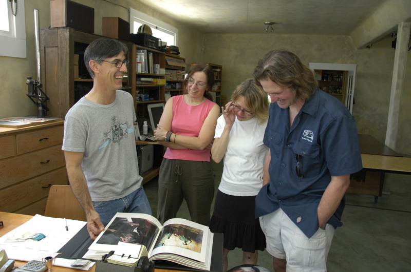
Being an accomplished photographer who has shot a lot of album covers and a book about Zydeco musicians, Rick also had a lot of images to show us. The day turned out to be a mix of music, Airstreams, photography, and talk about New Orleans — plus a lot of good food. No wonder we didn’t think to leave for five hours.
I didn’t mention this last night, but we are camped at Bayou Segnette State Park, in Westwego, across the Mississippi from New Orleans. This campground is one of the most popular in Louisiana, for good reasons. Not only does it have large open campsites and nice scenery, but swimming pools, a wave pool (not yet open for the season), and a boat launch.
The state park is full of living things, so densely packed that their presence is always noticeable. On a bike ride this morning we spotted an interesting gray snake which we have not identified yet. Coming back through the campground we saw brown rabbits everywhere, then in the early evening we spotted an armadillo industriously pawing through the grass for dinner, while Susan and I were playing ukulele music at the picnic table. At night a chorus of chirping and clicking comes out of the swamps that surround us, and continues all night until dawn when the birds start in.
Things are so different from the west. I still can’t believe the change. Despite a few dry days, we are starting to notice the humidity building up here. Upper 80s here today felt like 100 back in Arizona. The mountains have been replaced by extensive swamps, the javalina have been replaced by alligators, and the cactus are now mulberries. We are in the East now … or at least, we will officially be there tomorrow when we cross the Mississippi River and head to the Florida panhandle.
Our coordinates: 29 °53’19.43″N 90 ° 9’51.81″W
April 19, 2008 at 10:19 pm · Filed under Roadtrips
 The casino on Lake Charles did not get our business for breakfast. As it turned out, not only does I-10 roar overhead the RV parking area, but a very loud train comes by three or four times at night. The deafening noise of this train and its long horn blasts will wake anyone with normal hearing. So I slept until nine and found that Adam and Susan had uncharacteristically arisen very early and had breakfast already. We skipped the call of the buffet and just piled into the Armada to continue our journey.
Since we had only about 200 miles to go and all day to do it, we decided to try an alternate route to the New Orleans area. US 90 drops south and comes to the west bank of the Mississippi River via Houma. This is a road I’d never driven, despite having lived in Louisiana for five years back in the 1980s.
US 90 brought us past a turn-off for Avery Island, which is a spot of land surrounded by a meandering river (hence, “island”), where Tabasco sauce is made. Although it seems to be in the middle of nowhere, it is a fairly popular tourist destination. The Tabasco factory offers a free tour, but it costs $1 to cross the little bridge to enter the “island.” (This money is dedicated to maintaining security and ecological conservation on the island, says the brochure.)
Avery Island is a salt dome, which is basically a very deep salt deposit underground that has been pushed up by geologic forces. As a result, the island is a high point of land — a hill in a place where otherwise are no hills. Salt is mined, trapped natural gas and oil are pumped out, and on the surface they grow peppers for seed. It’s a pretty industrious little place.
It’s also somewhat exclusive. About 80 houses are on the island, all occupied by the families of full-time workers. Avery Island is really a factory town, privately owned by the family that owns the factory, and exploring the island (other than the factory and nearby Jungle Gardens attraction) is not encouraged.
The tour and look at Avery Island are worth the 6 mile detour off US 90, and the $1 toll, in my opinion. You get little samples of Tabasco sauce in the deal, too, and of course there’s a “country store” with everything imaginable that might involve Tabasco, including apparel and ice cream. (Eleanor says to try the Jalapeno ice cream.) There is a bus parking area which gave us plenty of room for the two RVs, so we stayed long enough to have lunch.
Tabasco factory coordinates: 29 °54’34.81″N 91 °54’11.34″W
The rest of US 90 was typical southern Louisiana driving: long stretches of bumpy concrete interspersed with occasional towns clustered around waterways. Eleanor spotted an alligator walking in a ditch near the road at one point, reminding me how very different everything has become since we crossed the invisible line between desert and swamp somewhere in east Texas.
We are now in a state park just outside New Orleans. We are close enough that this evening we drove over to Algiers and caught the ferry across the Mississippi (free for walk-on passengers) to Canal Street in New Orleans, and spent the evening walking the French Quarter. It appears completely unchanged since Katrina, which is not a surprise since the French Quarter sits on relatively high ground and was relatively untouched. The only thing that seems different is that Bourbon Street has gotten even sleazier, if that’s possible. It’s like an X-rated carnival midway now.
I got my long-awaited muffaletta from Frank’s, which was just as good as I remembered it, and then we experienced the rowdy bustle of Cafe du Monde around 9 p.m. for two orders of beignets, coffee, and chocolate milk. Emma, loaded up with powdered sugar and chocolate milk, was very happy. We all were. New Orleans’ French Quarter is a mad colorful display of excess sitting astride dignified history and fine dining. You can’t help but find it intriguing and repellent all at once.
April 18, 2008 at 6:33 pm · Filed under Roadtrips
Some days you can chew up hundreds of miles with the smooth asphalt whizzing beneath the wheels, just placidly towing along, one hand on the steering wheel and the other hand picking up snacks all day long. Those days seem to just drift by, like a day floating in an inner tube down a lazy river.
And then there are those other days, like today, when every inch of potholed roadway seems to have to be fought for against insane car drivers, mercenary trucks, and looming Jersey barriers. Those days are twice as long as other days.
We covered about 300 miles today, a big day for us, from Austin TX to somewhere near Sulphur LA. Along the way we plodded through stoplights on Rt 290 east of Austin and dodged maniacs in Houston traffic. Our favorite was a woman driving with a cast covering her entire left arm, and her right hand holding a cell phone near her mouth. Only her right elbow was contacting the steering wheel, in heavy Houston traffic. From there it was a series of construction zones along I-10 until we reached Westlake LA, home of the Isle of Capri floating casino on the shore of Lake Charles. It was not a pleasant drive.
After a drive like that, we are all pretty well worn out. We’ve made camp in the RV parking lot at the casino, and will just hang out and relax for a while. There are about a dozen other RVs here, some of which look like they’ve been here for several days. We have a nice view of Lake Charles from our front window and the constant roar of I-10 traffic overhead on the bridge.
Emma is challenging anyone who will sit still to a game of checkers, and that may be the height of our evening entertainment. Maybe we’ll watch a movie. We have low aspirations, as you can see. Tomorrow we might try the breakfast buffet in the casino, before we head out again. I’m anxious to get to New Orleans and get started on some of my favorite things there: crawfish, a muffaletta from Frank’s, beignets late at night at Cafe du Monde, and a long walk to get reacquainted with post-Katrina New Orleans.
Our coordinates: 30 °14’11.06″N 93 °14’54.63″W
April 17, 2008 at 1:49 pm · Filed under Places to go, Tips & Ideas
I mentioned earlier that we are transitioning from our PO Box in Ferrisburg VT to a mail-forwarding service in Florida. It’s something that we should have done a long time ago, but our local postmaster has been so accommodating about sending our mail to us that we never bothered.
Last week I talked to a budding full-time traveler who was doing the same sort of thing as us, and many others: having someone back home sort through and send the mail. It always seems like a good idea at first, but then problems tend to crop up. My advice to part-time or full-time travelers is to just bite the bullet and find a mail forwarding service early on.
The cost is not bad, generally $10-20 per month, but be sure to read the fine print and make sure your magazines will get forwarded too. The real challenge is getting all your accounts, family, and friends to adopt the new address. That’s the process we are in now.
For us the problem is worse because we have a house in Arizona now. Some businesses will insist on sending us mail there, even though we ask them not to. So to catch those bits of mail, we put in a temporary forwarding order from the Arizona address back to our PO box in Vermont.
Unfortunately, our postmaster in Vermont accidentally sent something to the Arizona address a week after we left. It was a license plate for an old used car that we recently bought to drive while we are in Vermont. The plate went from the Vermont DMV to our PO Box, then was forwarded to Arizona, and is now being forwarded again back to the PO Box in Vermont. Since the car is currently in Florida, we will ask for it to be forwarded again, where it will get installed on the car and driven back to Vermont. Got all that?
The license plate is like those gnomes that people mail around the world. It will be well traveled before it ever goes on a vehicle.
I’m not so worried about the plate but unfortunately a pile of mail also got sent from the PO Box to Arizona. It will eventually be sent to our mail forwarding service in Green Cove Springs FL, and then probably to Tampa, where we expect to be in about 10 days. Somewhere in this mail are several important checks that I’d like to have sooner. I wish I could get certain vendors to make electronic payments to the magazine rather than mailing paper, but not everyone is ready for that yet.
Life in Austin has been great. Every day we get a bike ride. Today Adam and I rode around the town paths, which are numerous and excellent. It makes an ideal break during long days at the computer. Tonight we are expecting guests for dinner again, and in the meantime a constant parade of interesting people come and go around Pecan Grove RV Park. I’m almost caught up on work, and the weather is fine. Can’t complain.
But we’re out of the west now. Even though Austin is considered the southwest by some, to us it feels noticeably different. There is some humidity, and grassy lawns. Very little cactus. Austin is well shaded by trees. All the signs are present, telling us we are about to enter the humid Gulf states. We’re a little sad about that because we all like the dry open spaces and the clear skies of the west, but there are many compensations where we are going, too.
For one thing, we’ll start to see beaches again — some of the best beaches in the world. And we’ll be chowing down on some seriously good Cajun food. Jill Smith-Mott, who is coming over for dinner tonight, wrote an article for the upcoming Summer 2008 issue of Airstream Life magazine which describes a great Cajun culinary tour. She has inspired us to spend a couple of days in the New Orleans area and chase down some of those edibles, and we’ll do that this weekend.
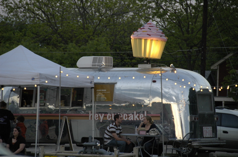
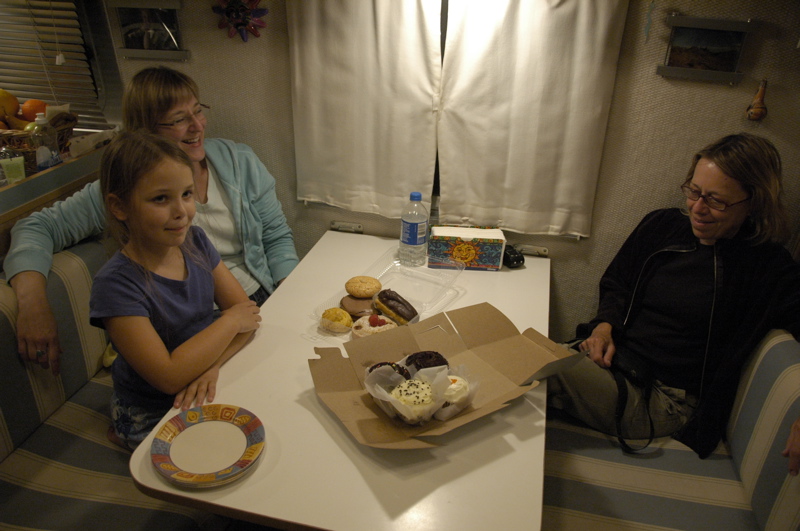
Speaking of the magazine, we’ll also have an article about Airstreams used for business, and one of the featured businesses is “Hey Cupcake!” which happens to be parked just about a mile from where we are right now, on South Congress Street. We saw the trailer last night and tried the cupcakes, which were — as expected — really excellent. The owners say they are going to launch more Airstream locations around town soon. Give ’em a try if you are in town.
April 16, 2008 at 10:01 pm · Filed under Places to go, Roadtrips
I’m still catching up on emails and blog entries since we came out of Big Bend. I came back to 229 emails, of which about 150 were spam. The rest required time to deal with …
My blog yesterday about being misguided by the GPS, and the need to keep your eyes open to “sanity check” routes was reinforced on our way out of South Llano River State Park. A bridge on the way to I-10 was being renovated, and orange signs said the clearance was 10 feet wide and 10 feet high. Our trailer is nine feet seven inches tall and eight feet six inches wide, so we would have cleared it, but our friends following us in their motorhome were too tall. This meant an abrupt detour and some quick navigating to get back to I-10 via an alternate route.
Since I needed to get back to reliable Internet, we decided to head straight for Austin for a few days. This meant skipping the hill country west of Austin, which is a shame. Still, we paused in Fredericksburg, a German-accented town in the hill country, for lunch and pastries, with the two Airstreams parked on a side street. We also stopped at the Lyndon B Johnson State and National Historic Park. Everyone checked it out while I stayed behind in the Airstream to deal with about fifty of the most pressing emails.

When we are in Austin we always visit Pecan Grove RV Park. I’ve written about it before (you can check the archives using the Search box at right). It’s one of a dying breed of urban RV parks, just a short hike from all kinds of downtown attractions. Massive economic pressure seems sure to doom this funky green oasis. The neighboring park (Shady Grove) just closed down last week and sold for $8 million.

The clock is ticking on Pecan Grove, but the residents here have a campaign to save it somehow. The only strategy I’ve heard so far that seems to have a chance is to get the park named a historic landmark. Considering all the amazing people who have lived here, and the things that have happened here, it might just work.
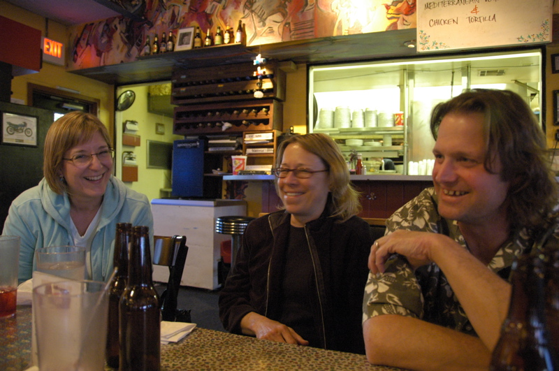
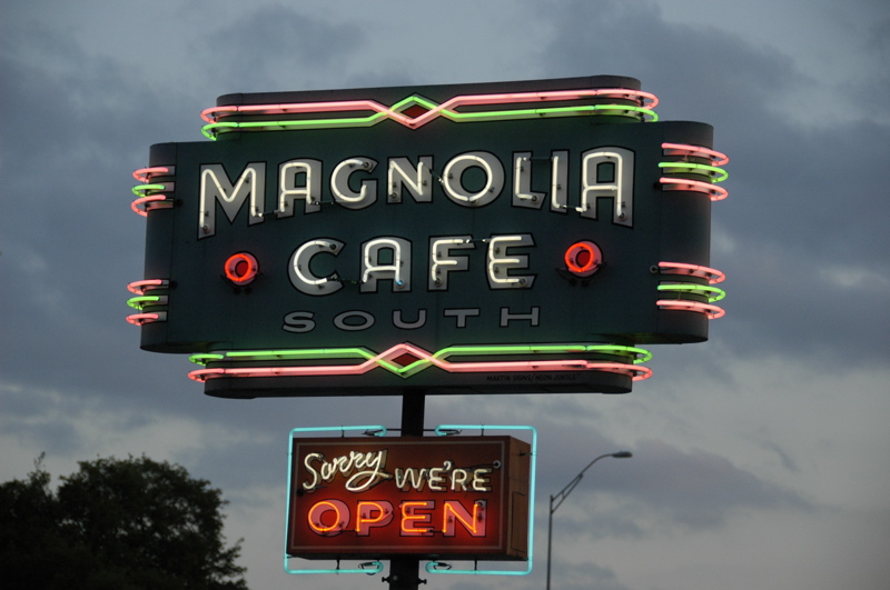
At lunchtime I was visited by John Irwin, who writes for Airstream Life magazine, and this evening we went out for dinner at the Magnolia Cafe on Congress Street with my friend Vicki, who lives here. We realized tonight that we’ve known each other about twenty years. Was it that long ago that we were cycling the streets of eastern Massachusetts together?
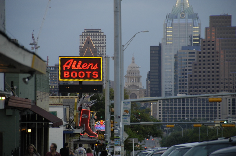
Austin seems to have a much higher ratio of neon-lit signs than other cities. I’ve noticed this in past visits but never had a chance to really get out at sunset and shoot the signs. Tonight I captured a few, and I hope to get out again on Thursday night for a few more.
Austin is a great town, with a really lively vibe. It has great food, lots of live music, and interesting people. Unfortunately, in some ways it is outgrowing its infrastructure. Traffic is often terrible. That’s another reason I’m glad we are able to stay in the heart of the city here at Pecan Grove. We’ll spend another couple of nights, so I can continue to get caught up on work, and then press on to Louisiana.
April 14, 2008 at 5:35 pm · Filed under Mobile technology, Tips & Ideas
Coming out of Big Bend I am always reminded of why visitation in the park is not as high as more northern parks. Big Bend is on the way to nowhere, since it borders Mexico and there are no roads across the border there. You have to detour at least 100 miles to get there, and coming out on Rt 385 back to Rt 90 or I-10 involves a couple of hours of driving through a lot of empty desert.
Once we reached Ft Stockton at I-10, around lunchtime, I was pleased to find that my theory about the magazine being somewhat more self-sufficient had held true. I had only two voice mail messages, and neither were business-related. But I didn’t bother to open up the laptop and check email just yet, because I knew I’d have an onslaught of at least a a hundred emails, and probably more.
On I-10 in west Texas the speed limit runs between 80 and 85 MPH (70 -75 for trucks) during the day. It’s tempting to try to tow the Airstream that fast, but there are several good reasons not to. First off, the trailer tire manufacturers recommend limiting speed to 65 MPH. Given all our tire problems lately, I am heeding their advice. The prospect of a blowout still scares me. Second, our fuel economy plummets. At 72 MPH, we burn about 35% more fuel than we do at 65 MPH, and even with all 305 horses pulling hard, the Armada has to downshift frequently to third gear to maintain that speed on hills.
A third reason used to be that the combined rig didn’t handle well at high speed, but that’s no longer true. When we first started tow without the Hensley hitch, 64 MPH was our maximum speed and 59 MPH was max in any sort of wind. With the Hensley we can go as fast as we want with superb handling at all times, but I still prefer to keep it at 65 MPH or less for fuel economy.
Speaking of fuel economy, we paid $3.89 for a gallon of fuel at Rio Grande Village. I’d rather get 10 miles out of that gallon (cost per mile: 39 cents) than 8 miles (cost per mile: 48 cents). When you realize that going 72 MPH saves us 27 minutes on a 300 mile trip (versus going 65 MPH) but costs us $27 more, the choice is pretty obvious.
South Llano River State Park is a fine place to camp, with big grassy campsites and lots of shade trees, but I found no usable Verizon signal here, which meant my phone and Internet connection were inoperable. There’s no wifi to be found either. A neighboring Airstream owner, Sharon, came by and said she’s been using the library’s wifi in town. She’s been here for two weeks waiting for parts to arrive for her late-model 20-foot Safari, which was damaged on the way here.
Sharon’s predicament brings up a cautionary note. The Garmin GPS that we and many others use is a great tool ““ most of the time. But you have to sanity-check it, especially when getting off the highway and going to state parks. The GPS is programmed so that it will choose either the quickest (time) or shortest (mileage) route. This means it will send you down a bumpy dirt road over a one-lane bridge if it calculates that this will shave 10 feet or 10 seconds off your overall trip.
That’s what it did to Sharon. Her GPS said to turn left, and she found herself facing a dead-end that wasn’t in the GPS database “¦ at night “¦ with no one in the truck to help her. She tried to back up in the dark alone and met a tree, which left her with $12,000 worth of aluminum damage and an enforced two-week stay here at South Llano River State Park.
The best strategy is to ignore your GPS when you start seeing the brown state park signs. Those signs will bring you in the best possible way. Don’t trust “Garminita” when she tells you to take a suspicious-looking left down a one-lane road. She’s a handy navigator but she doesn’t know you’re driving a long tall rig that can’t turn around on a dime.
 Two weeks of intervening time has given poor Sharon a chance to get over her disaster, and she’s been enjoying the peacefulness of the park while she works remotely on magazine designs for her clients. Since she’s a portable professional like me, the time has been useful and frankly there are a lot worse places to be “stuck” for two weeks than South Llano River State Park.
For us, however, a move is imminent. I need to spend some heavy time finalizing details for the Summer magazine. It is heading to the printer tomorrow. That means we will move to somewhere that I can get online for a few days.
On Wednesday we will arrive in a favorite spot, Pecan Grove in Austin, for at least two nights. This shady little oasis in the heart of Austin is one of the few urban campgrounds left. I’m hoping some of our friends in the Austin area will come out to meet us there.
April 13, 2008 at 1:04 pm · Filed under Places to go
This trip to Big Bend has been the most relaxing and enjoyable trip that I’ve ever had here. So relaxing, in fact, that I have not even attempted to write my usual daily blog entries. It is a small revelation for me, because (I have to admit) this is the first year that I’ve been able to fully enjoy being disconnected from the business of running Airstream Life instead of worrying about it. Finally, the business is reaching a level of maturity where I can go away and not fear a dozen “urgent” phone messages and a flood of bad-news emails upon my return.
On prior trips to Big Bend and other great places, the experience has been tainted by business concerns which have lurked in the back of my mind. It’s a shame to walk through a beautiful place and not see it because of worries about some concern back at home or work, and sadly a large number of our excursions have been afflicted by that. It is one of the risks of traveling while working (as opposed to being retired or on a leave of absence). Since in my case there isn’t any near-term solution to having to work, I resolved last year to resolve the problems that have been the cause of many a blighted trip, and at last I am approaching that goal, which is a great relief.
Of course, not all problems can be resolved simply. I had to choose to not worry about those things that I can’t control ““ something that is easier said than done. While we are out of touch, a thousand awful things could happen and I could come back in touch with the world on Monday to discover them, but of course the trick is to not let those worries invade the mind.
In this, I have been mostly successful. We have hiked at length, eaten heartily, and slept well. We have learned, and taken photos, and laughed and relaxed. In this age of instant communications, the outside world still has trouble penetrating the eastern edge of Big Bend National Park, at Rio Grande Village, where we’ve spent the last four nights.
It was a long scenic drive down TX 118 to Study Butte ( “Stoody Bee-yoot”) and into the western entrance to the park. Along the way, Ft Davis National Historic Site made a good mid-day stop, where we renewed our annual national park pass and Emma earned yet another Junior Ranger badge. I think at this point she has thirty or so, but we’ve lost count. They make a great contribution to home schooling.
The snowbirds have fled the southwest, so we had no trouble showing up at the only full-hookup campsites in Big Bend, at Rio Grande Village, and obtaining two sites for ourselves and our friends. It was 95 scorching degrees at 6 p.m. and the temperature hardly dropped after sunset. But the next day it was cooler and on the second night a cold front came through and dropped the temperatures into the 70s, making for perfect outdoor conditions. Being desert, it hardly ever rains here, and the air is comfortably dry for hiking.
 The “trailer village” at Rio Grande Village is not particularly attractive, in that it is a basic asphalt parking lot with close spaces, but it is in the middle of a large green oasis of cottonwood trees and Bermuda grass that is carried over from a pre-existing 1920s ranch. Large natural springs all along the Rio Grande and an extensive irrigation system still serve to flood the grassy areas, and the Park Service has chosen to maintain that historical environment rather than let the area return to native desert. Huge turkey vultures rest in the trees above us, and in the early evening they give us a show by soaring close by.
Adam and Susan have been encouraging hikes and long talks daily. We did not come to Big Bend with any particular agenda, but it has turned into a series of hikes every day, which we all like. Talk goes well with rhythmic hiking over miles of terrain, and so we have managed to cover a lot of ground both philosophically and literally in the past few days.
 Our first hike was an easy warm-up to Boquillas Canyon. This is 2.8 miles roundtrip. We went to go see our friend Victor Valdez, who is becoming somewhat famous as the “singing Mexican” and spokesman for the little town of Boquillas del Carmen, across the river in Mexico. (You can see him on YouTube.) On many days, Victor can be found with his friends on the Mexican side of the Rio Grande, waiting for tourists to come by. The town of Boquillas used to sustain itself as a tourist destination, but since 2002 the free access by Americans across the river to Boquillas has been prohibited, with the result that the people of Boquillas have to sustain themselves by selling trinkets to tourists (contrary to US law) by wading across the Rio Grande, and by soliciting donations.

In Boquillas Canyon there is a steep sand hill which everyone except me climbed (I stayed below with the backpacks and to take photos), and Adam had a nice time tumbling down it.
 Our afternoon hike, under a hot sun, was the Canyon Rim hike that overlooks the Rio Grande. This one is six miles roundtrip, but at the turnaround point we were able to pause at the riverside hot springs, and to take in the petroglyphs and pictographs nearby.
Hiking for hours in the desert is enough to feel justified that you’ve done enough for one day, so we retired to the Airstreams for the evening and only ventured out again for a brief ukulele lesson. Adam bought Susan a nice concert uke last week in Tucson, and she was eager to pick up a few initial pointers. It’s a lot of fun to be able to share the uke with other people, and Susan is a very quick learner.
 Hiking in the desert for hours on a hot day is also enough to drain a Camelbak drinking reservoir, I found. The Camelbak I brought holds a hefty 100 ounces of fluid, and Emma and I drained it completely in the course of our two hikes, plus an additional 20 ounce bottle of water, and then much more once we were back at the Airstream. Out here the general rule of thumb is one gallon of water (128 ounces) per person per day, when hiking, and I can tell you that when the temperatures exceed 90 degrees, that’s no exaggeration.
We did the same the next day, too. A midnight wind rose up and dropped the temperatures by 20 degrees (and forced me up in the middle of the night to take in the awning). This made things very comfortable down in Rio Grande Village, but a bit chilly up in the Chisos Mountains in the middle of the park. Susan, Adam, and I decided to take a hike down “The Window” trail in the Chisos, while Eleanor and Emma hung back to relax and work on Emma’s Junior Ranger program. In the Chisos at 5,400 feet, the temperature was a mere 43 degrees when we started hiking, quite a difference from the 95 degrees we had experienced just 48 hours prior.
That hike added 5.2 miles to our total. The Window is probably the most popular and famous hike in the entire park, because it is relatively easy and the view at the end is spectacular. We finished in time to have lunch at the Chisos Mountain Lodge, which features spectacular views and is (surprisingly) reasonably priced for lunch.

At this point I was thinking we might be done with hiking, but in a place like Big Bend you just have to go for a hike if you want to see the diversity and beauty of the park. So a couple of hours later we re-grouped with E&E and drove out on a rough backcountry road to make the short hike to Ernst Tinaja. This hike is another favorite, with the highlights being a natural watering hole (tinaja) in a dry cascade, and incredible fossils just a short distance further up the wash. It’s a short hike, about two miles roundtrip.
 At this point I realized that we weren’t going to be back to Big Bend for a long time, possibly years, and I wanted to get the most out of it, so when Susan suggested a bike ride before dinner, I was ready to go. Less than a mile from the trailer village is the national park service’s campground (a nice spot, no hookups, but with fresh water and a dump station, $14), and “¦ you guessed it, another hike. This time we just hiked a piece of it, to get a look at the beautiful pink limestone cliffs in the late afternoon sun and the little town of Boquillas across the river.

In the evenings we’ve been watching a program on DVD called “Life in the Undergrowth,” which is an educational series about insects and other little critters. It’s fascinating, and the best part is that Emma doesn’t know it’s educational. All day long, on hikes (looking at fossils and geology), doing her Junior Ranger program, and then even watching TV, we are home schooling and it’s completely painless. National parks are a great place to learn about the natural world.
Sunday I was actually a little resistant in the morning, but since everyone else was gung-ho, we launched out to do the second-most popular hike in the park: Lost Mine Trail. This hike, also in the Chisos at high elevation, was probably the most beautiful we’ve done, and that’s saying quite a bit. I can see why it is popular. It’s a moderately steep hike most of the way, 4.8 miles roundtrip, and peaks out close to 7,000 feet. The views along the entire trail are fabulous, and the top view is worth twice the hike.

At this point we are done hiking. Actually, I think we’d all be up for another one but we are having trouble finding more good hikes on this side of the park that are under ten miles. We could move to the other end of the park for a few days, but time is pressing and we need to plan the rest of the trip to Florida.
We did a little of that this evening, after lunch at the Lodge again, and another fun uke lesson at the campground. Our next deadline is May 1 in Orlando, and there is much we want to do before then, so we will launch on Monday morning. Our next stops will be along I-10, then in the Hill Country west of Austin, then in Austin itself, then the New Orleans area.
« Previous entries ·
Next entries »
