September 25, 2008 at 10:55 am · Filed under Places to go
There is only one trick to seeing Betatakin Ruin, one of the best-preserved cliff house dwellings in the entire southwest: get up early.
The reason is the crazy time zones around here. Arizona does not observe Daylight Savings Time, so it stays on Mountain Standard Time all year long. However, the Navajo nation does observe Daylight Savings Time, which means that in the summer it is one hour later here than in the rest of Arizona.
Seven people signed up for the ranger-led tour of Betatakin Ruin, but only five showed up at 10:00 a.m. MDT. The other two were probably thinking they still had an hour to get ready.
 Betatakin is a jewel among the many Ancient Puebloan ruins scattered around the Four Corners. Tucked under a massive natural alcove, it has been preserved from rain for over 700 years. It is a fairly large dwelling, with several kivas, pictographs and petroglyphs, and a “supergranary” high above for food storage. We saw dried corn cobs and potsherds all over the place, and original wood still in the ceilings. It was an amazing tour.

 The only way to see Betatakin up close is to take the free ranger-guided hike. If you are physically capable, you definitely should make the effort. The interpretation done by our ranger was superb, and with five hours of hiking and viewing time, we got a very good understanding of everything we saw. This was undoubtedly one of the highlights of our Four Corners tour, and that’s saying a lot!
Taking the tour requires that you be able to hike five miles with a descent and ascent of 700 feet including some steep switchbacks and a little bit of sand. The altitude is 7300 feet, so being acclimated for at least a few days is essential. You also should have good hiking shoes, at least two liters of water per person, snacks, and all the usual sun-protection stuff (hat, sunglasses, sunscreen). But for all the warnings and preparation, it wasn’t terribly hard and it certainly was well worth the effort.
 You have to be here to understand the beauty of this place. Even if you can’t do the hikes, the rear patio of the visitor center will give you a clue. The air is clear and the long canyon vistas are gorgeous. Down in the canyons and sandstone alcoves there is water, year-round. The stone provides shelter from heat and rain. Wildlife is hidden but present. Everything you need to survive is here, if you have the proper knowledge.
The Ancient Puebloans recognized the values of this area and managed to “dry” farm it for decades before they suddenly (and mysteriously) moved on. Today, the Navajos live here, a bit modernized, but still carrying on values and traditions that have been part of their culture for centuries. Both the Navajos and the Ancients have their secrets, making the entire place seem mysterious and magical.

We were so impressed by today’s tour that we are talking about coming out next year to hike 17 miles (roundtrip) to the Keet Seel ruin. We’d tent camp overnight for that one. It’s logistically a bit harder, but within our grasp with a little pre-planning. Perhaps in June”¦
Navajo NMON may be little visited, and far off the beaten path, but I can recommend it. Bring what you need, and stay a couple of days.
September 24, 2008 at 10:28 am · Filed under Places to go
About 80 miles from Page through rugged and open Navajo country has led us to Navajo National Monument. I can only post a quick blog right now because we are going to head off for a 5-hour ranger-led hike to Betatakin Ruins, which you can see in the photo below. Getting to the canyon involves a lot of backcountry hiking on switchbacks and sand, to across the top of the plateau shown in the photo, then down into this deep canyon, and back to the overhang where the ruins can be explored.

Navajo NMON is one of those little-visited park sites, but it is beautiful, open, peaceful, and engaging. The weather is spectacular: sunny days in the upper 70s, clear dry nights in the 50s. We found a spot for our trailer in the small campground (length limit 28 feet), and immediately decided to stay two nights at least. (It doesn’t hurt that camping is free here, up to 7 days. Bathrooms and water available, no hookups, no dump station.)
The campground is very pretty, with wonderful day and night views. The stars are almost as good as at Hovenweep, which is not surprising since we have come around almost full circle in our Four Corners tour, and are not that far from Hovenweep. I am really starting to love this part of the Four Corners.
In the visitor center there are Navajo women making rugs and sashes, which you can buy. The 2.5 ft x 4 ft rugs run $600, so we didn’t get one, but from all accounts they last forever. Since these women rely on tourists for their income, they also charge to take pictures of them working ($5). The work they do is intricate and beautiful, and I wish I could buy something just to support the tradition. From what I hear, it is dying out as fewer Navajos choose to learn these techniques.

I experimented last night with nighttime star photography for the first time. The results were not great — I got a reddish flare in the upper left corner of all my long exposures, and lots of “noise”. I need to read up on the right settings to use, because the night sky here is too stunning to let pass by without some more photos.
I am also amazed I’m able to get online with my Verizon card (for the record, from site #4). I’ll post again tomorrow with photos from the Betatakin hike.
September 23, 2008 at 9:42 am · Filed under Uncategorized
I really like visiting Page. In the first couple of years, when we were keeping an eye out for possible places to establish a home base, Page went on my list. I like the fact that it is remote (80 miles from any other towns), surrounded by classic southwestern recreation, has a massive lake, is in the desert, has good local services, and enjoys fine weather.
But we eliminated Page from the list because we ultimately decided that a home base needed to be closer to a city. We wanted the option to conveniently fly out if needed, and the added resources that cities bring. These criteria also knocked the beautiful Owens Valley (CA) off our list.
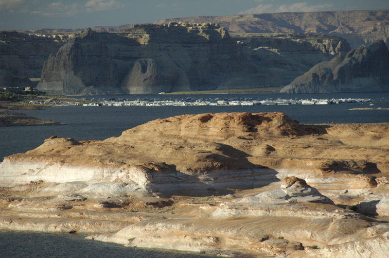
At 4300 feet elevation, Page is also a little higher than I’d like for over-wintering. Tucson made a better fit for its relatively low altitude, averaging about 2000 feet. But Page is undeniably a nice spot. From many places in town, you can see Lake Powell, a startling blue jigsaw puzzle piece sitting in the middle of sandstone formations just a few miles away. I like seeing glimpses of it while in town doing routine errands.
The lake is here to stay, but that doesn’t mean there isn’t some controversy about it. The Glen Canyon dam that created the lake prevents the Colorado River from seasonally flooding the lower river basin, especially in southern California. It also generates over a gigawatt of electrical power (when the lake is full), and of course the lake makes a nice recreational spot.
The downsides of the dam are numerous, and you’ll hear about them from the National Park Service rangers all over the southwest. For example, the dam prevents silt and gravel from reaching points downstream, thus stopping the natural erosion of the Grand Canyon, and wiping out riverside beaches. The lake has altered the desert ecosystem, bringing in lots of non-native species and eliminating others. The beautiful Glen Canyon is gone. Loss of floods has eliminated the natural renewal of nutrients in the Imperial Valley, forcing farmers to use petroleum-based fertilizers. The list goes on and on …
And the dam won’t last forever. It will silt up beyond usability in 500 years, but long before that it will start to have age-related problems and eventually somebody is going to have to figure out what to do with it. All of the dams built on the Colorado have the same issues. Hoover/Lake Mead will get a little extra time because Glen Canyon is capturing more of the silt (being upstream).
So Page is a beautiful spot today but also temporary. It was built as a worker’s town in the 1950s, enjoys its heydey right now, and will perhaps someday fade if Lake Powell disappears in the distant future. It could happen. You only need to look at the impact on Salton City, CA, as the accidentally-created Salton Sea evaporates today.
We’ve managed to get our shower drain working again, at least enough to be usable. (I’m going to buy one of those gadgets that our friend “Gadget” used on his shower.) We’ve refilled on groceries, propane, gas, and water. We’ve done all the immediate work and online banking that needed to be done. So with all that completed, we are going to leave Page today and head into Navajo country.
That’s not far — just to the edge of town — but from here the Navajo Nation extends to the New Mexico border, and beyond that are other Indian nations. The entire northeastern corner of Arizona is Navajo and Hopi territory. It is open, spread out, occasionally rugged, and very quiet. Towns are scarce. It’s really more of a series of scattered outposts, with amazing pre-historic gems here and there, and our intention is to visit several of them this week. Cell phone coverage is unlikely in most of the area, but if I can find some wifi I’ll update the blog as often as possible.
September 22, 2008 at 2:19 pm · Filed under Maintenance, Roadtrips
Leaving the Grand Canyon’s north rim to Page AZ is one of those spectacular roadtrips that can only be found in Arizona or Utah. From Grand Canyon you cruise along Rt 67 to Jacob Lake, a small outpost in the Kaibab National Forest that is a nice destination in its own right but massively overshadowed by the Grand Canyon 47 miles away.

 From Jacob Lake the road descends on Alt. Rt. 89, passing from Ponderosa pine forest, past gorgeous views of the Vermillion Cliffs, and eventually to high desert. At a viewpoint near the Vermillion Cliffs, just after entering the Navajo Nation, there is a large pullout where Navajo women have set up stands to sell art and crafts made by dozens of Navajo artists they represent. The stop is worth making just for the views of the Vermillion Cliffs — the best view we’ve seen yet — but the items for sale are also beautiful.
A bit further you pass the little outpost called Cliff Dwellers, where there is a small motel, a restaurant, and a few homes butted up against the red stone of the cliffs. Amazingly, fly fishing in the perennial streams of the nearby canyons seems to be the major attraction of Cliff Dwellers.
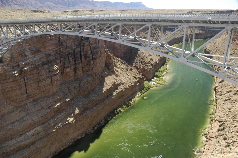
The road bottoms out at about 3,000 feet at Navajo Bridge, which crosses the Colorado River at a narrow spot above a very tall gorge. The bridge, originally built in the 1920s, is a steel arch type which appears to hang 700+ feet above the deep green water of the river below. Actually, it was replaced in 1995 by a larger but nearly identical bridge, and so you can now walk across the old bridge for the view. Well worth the stop, but keep in mind that there’s no RV parking. We “invented” some along the exit road and the ranger on duty did not mind. There are covered picnic tables near the bridges so it makes a nice lunch stop.

From Navajo Bridge the road climbs again to the south, until Alt Rt 89 joins Rt 89 and you have a choice: Flagstaff or Page. We turned left (north) to Page and immediately began a climb through the red cliffs where pullouts give you an outstanding view of the plateau below. The road slices through a notch in the cliffs and you’re back up at 6000 feet. Then it slowly descends down a tilted plateau to Page.
Page was originally a workers town for the builders of the Glen Canyon dam that formed Lake Powell. When the dam was proposed, there weren’t any towns for 80 miles, no roads, and no rails. Today it’s a modern town with golf courses and marinas on Lake Powell, but it’s still a long way from anything. This, plus the fact that it is located smack in the middle of some of the most beautiful landscape in the southwest, makes it a popular stop for RV’ers.

The National Park Service offers a free 45-minute tour of the Glen Canyon dam, and this is another stop well worth making. The views from the bridge and from the Visitor Center are breathtaking on a nice day — and it’s usually a nice day out here. Emma snagged a Junior Ranger badge there, too, in about 90 minutes.
The last time we were here we stayed at Wahweap Marina on the shore of Lake Powell. It’s a very nice spot, but this time we wanted easy access to services. The Super Wal-Mart on the main road is unbelievably convenient, with a Shell station across the street that has an RV dump, fresh water, propane, gas, diesel, and air. We needed three of those things, plus a bunch of supplies at the Wal-Mart.
Last night while taking a shower I noticed the water was extremely sluggish going down the drain. Not surprising, since I live with two females who have long hair, and we have to take apart the bathroom sink trap two or three times each year to remove clogs of hair. But the shower drain is not as accessible, which is why we always have a small screen in the drain to catch hair. So what was the problem?
We tried a jug of liquid drain stuff last night but there was no effect at all. This morning we ran into the Wal-Mart for a snake, and it was a bomb too. It hit the pipe walls at the trap and wouldn’t go any further. Then we got a plunger and applied some effort with that.
The plunger yielded some small improvement, plus a lot of sand regurgitated by the drain. Aha! We washed off some dirty feet back at Great Sand Dunes National Park last month. We think that, combined with the other things that go down the drain, the sand had formed a clog that corrosive drain cleaners couldn’t touch.
At this point the shower is usable but still slow. We could have an Airstream dealer take apart the drain (requiring opening of the belly pan beneath the trailer), but first we’re going to try to use the water hose at the Shell station to push the sand through the trap. That requires removing the lower half of the bathroom window, then the screen, so we can snake the hose into the bathroom, but I’ve done it before and it should be reasonably straightforward. This is what on-the-road maintenance looks like sometimes.
September 21, 2008 at 8:48 pm · Filed under Places to go
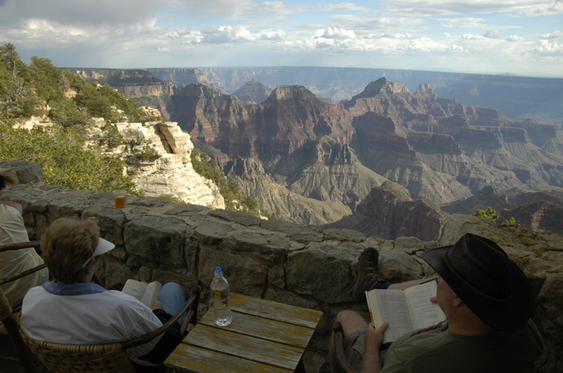
We left a few easy things for Saturday so we could have a relaxing day with Daisy and Don. For the most part, our plan was simply to drive out to the east end of the developed part of the North Rim and peer over the edge. We walked no more than a mile all day, and spent most of the time talking with Don, Daisy, and people we met along the paths.
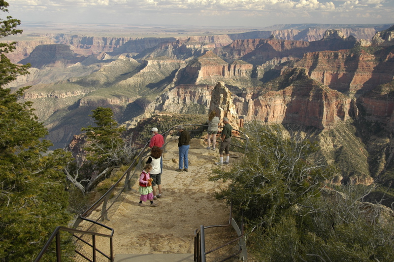
This part of the park has a couple of paved roads that wind out to fancifully-named points and overlooks: Cape Royal, Cape Final, Point Imperial, Vista Encantada, Walhalla Overlook, etc. To me, the names evoke the early days of the canyon’s development in the 1920s and 30s when Union Pacific’s subsidiaries were busy trying to make the canyon into a world-class tourist destination. Each overlook has its own distinct view, sometimes canyons, sometimes the Colorado River, sometimes the lower plateau of the Navajo nation to the east.
 Of course we dropped in on a ranger talk along the way. Emma got put to work, grinding blue Navajo corn the old-fashioned way.
 When we went by the Visitor Center in the late afternoon to get Emma’s Junior Ranger badge, we spotted a Grand Canyon Pendleton blanket hanging on the wall, and loved it. Ever since Fred Coldwell wrote an article about Pendleton’s national park blankets in the Spring 2007 issue of Airstream Life, I’ve been looking for one. So we bought it as a late anniversary present to each other (we had our 15th anniversary earlier this month). This one will keep us a bit warmer while at high elevation, but mostly I am looking forward to having it on our couch back at home base this winter.
Don and Daisy are work-camping here in the park, but mostly because they want to spend a lot of time on the north rim. With employment by the park’s concessionaire, they can stay six weeks or more in the employee campground with full hookups for a mere $5.50 per day. Usually they just volunteer; this is the first paying work-camping job they’ve accepted this season. With weekends off, they’ll have lots of time to explore before the north rim shuts down on October 15.
The north rim shuts down because of the heavy snows that blanket the Kaibab Plateau. The road coming into the park goes above 9000 feet, and keeping it open requires massive equipment. As far as I know, it has been closed each season since the lodge was built. The campground and lodge are about 8200 feet and I was told that last winter 14 feet of snow fell here.
Even now the chill is starting to creep in. The campground’s checkout time is 10 a.m., but at 6:30 the tenters are all up and pacing around, or making fires for breakfast. They start packing up early, and by 8 a.m. the campground is mostly empty. But still the campground fills every day, and it seems it will do that until sometime in October.
We have to leave today. No spaces are available to extend our stay, and I’ve got work to do on Monday anyway. Our plan is to drop into Page, AZ for a couple of days to get things done before heading into the Navajo Nation, and over to Canyon de Chelly.
September 20, 2008 at 12:09 pm · Filed under Places to go
On our first visit to the south rim of the Grand Canyon (last year) we restricted our hiking to the rim. Rim hikes are generally easy, without any real elevation gain or loss, and they are a great way to see the canyon with the perspective of altitude.
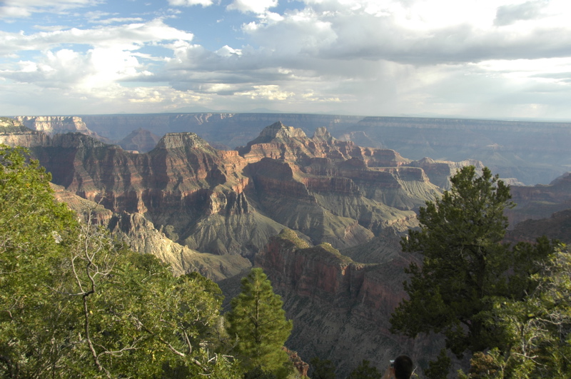
This time Eleanor wanted to hike into the canyon, at least a small distance. To hike to the bottom of the canyon, especially from the north rim, is a serious undertaking. The bottom of the canyon is at the Colorado River, 14 miles from the north rim. It’s not a day hike.
For day hikers like us, it is only possible to go a relatively short distance down. With a full day, we could have gone Roaring Springs, 4.7 miles one way and 3,000 feet below us. But we decided to check out Bright Angel Point first, a relatively easy hike from the Lodge about 0.5 miles roundtrip to a spectacular viewpoint. This would be our warm-up, and a chance to measure the canyon’s visibility (which turned out to be about 70 miles).
Bright Angel Point has short and steep ups and downs along its length. The total elevation gain/loss is not much, and the trail is entirely paved, but it seems hard. We encountered a lot of people struggling to make the uphill slopes. Even a short climb can be a challenge if you are out of shape, especially at Lodge elevation of 8,250 feet. It was a reminder that we were going to be facing a challenge on our next hike.
We chose the popular North Kaibab Trail, which runs from a trailhead on the north rim all the way to the south rim. It’s possible to do a rim-to-rim hike on this trail, with an overnight stop near the Colorado River or at Phantom Ranch, but you need to plan a year in advance to get the necessary backcountry camping permit or ranch reservation. The total trail distance is 24 miles to the south rim. We’re thinking about it for next fall. I heard that John McCain does it every year with his family. If he can do it, we can do it.
Our afternoon hike, however, was considerably less ambitious than rim-to-rim: 1.7 miles of steep downward trail, losing a total of 1,450 feet, a break at the Supai Tunnel and a refill of our water, then back up the same distance. By Grand Canyon standards this is a pretty straightforward trip, but don’t kid yourself about it. Rangers say to allow twice as much time to get back up as you took to go down, which is a reasonable guideline. Imagine taking the stairs from the top of the Sears Tower all the way to the ground, then going back up to the roof. Then imagine how you’d be breathing on those stairs if the basement were at 6,800 feet above sea level.
A total of 3.4 miles isn’t much for us normally, but the steep climb was psychologically challenging to Emma, and physically challenging to Eleanor’s asthma. On the way down, we met a pair of rangers who were concerned about Emma overheating on the climb back up. Kids often do that, because they are smaller, don’t manage their energy well (sprinting ahead), don’t remember to drink water, and prefer to eat the wrong type of snacks.
I was concerned as well, but we had prepared for this. Last week in Kanab we bought Emma a 1.5 liter Camelbak hydration reservoir and hooked it up to the purple backpack that her stuffed cat Zoe always rides in. That made it easy for her to drink steadily through the hike. At the rest stops we plied her with a mix of snacks designed to keep her energized and keep her electrolytes where they should be.
How your body feels has a lot to do with what you think you can do. But even with experience on many other hikes, and appropriate food and water, she faced the tough challenge of breaking through the mental barrier of “I can’t do this!”
This is always the low point of any tough hike we do. “I can’t!” is a kid’s way of expressing a more complex set of thoughts: I’m tired, I’m thirsty, I’m regretting that I got into this, I don’t know what’s going to happen, I’m afraid of failing, I’m afraid of getting hurt, I don’t know what I’m supposed to do, etc. We’ve been here many times before, and I suppose most parents have been. Whether it’s learning to ride a bike, do a math problem, or tackling a steep hill, it is never easy to get past the “I can’t!” barrier.
I think a lot of people choose to avoid this awful moment, standing somewhere in public, trying to negotiate the murky world of a child’s psyche while other people wander by with their opinions etched on their faces, and the clock ticks against some pressing deadline like sunset. So they try to avoid situations like this. We decided early on that the challenge was worth the results, and so far it has been. I won’t say it has always been fun, but in the end we always get where we are going, and Emma always comes out of it feeling better about herself than she went in. Experience is a great teacher.
By the second half of the climb Emma was feeling fine and even leading the parade, and my thoughts then went to Eleanor, who certainly never would have done something like this fifteen years ago, and still probably shouldn’t do something like this in the humidity of the east. She has also conquered some of her fears, and learned to manage her asthma to the point that she can hike uphill 1,450 feet in 1.7 miles and do it in a very respectable time.
Coming out of the canyon on any hike, you can’t help but be awed by the vastness of it. We are merely ants in this massive place, and our efforts are puny when pitted against the environment of the canyon. The canyon can swallow us in a few hours. It is only through cooperative effort and modern technology that so many people manage to survive it.
It isn’t the deepest, the widest, nor the longest canyon in the world, but it is indisputably the grandest. I think the fact of its grandeur makes us want to be part of it, because by joining the canyon you are forced to see yourself as you are: an individual speck in something much larger. The introspection that comes from hiking the canyon is good for your perspective and for your self-confidence. I think we have all benefited from that.
Another thing I can tell from our past couple of days’ experience: three nights is not nearly enough. If we could get a campground opening for Sunday night I would definitely take it. Or, if we had some friends in the area who could go with us, I would go back up to Kanab, park the Airstream, and take the 61-mile dirt road down to Toroweap (also known as Tuweep) and tent camp on a different section of the north rim for a couple of nights. One of the outcomes of our last month traveling through southern Colorado, Utah, and northern Arizona is that we have a long list of places we want to come back and explore further. The best thing we can do is make notes and look forward to next year’s trip.
September 19, 2008 at 12:29 pm · Filed under Places to go
For some reason people often thing that the Grand Canyon is in Utah, or that it is divided by the states so that the north rim of the canyon is in Utah. This may stem from the fact that most of the other major southwest parks are in Utah (Zion, Bryce Canyon, Capitol Reef, Canyonlands, Arches, etc), but in fact the entire Grand Canyon sits firmly in Arizona, our adopted home state.
In western terms it’s not a long drive from Kanab, UT down to the north rim ““ about two hours, versus three days in the horse-and-buggy era before the road was put in. But to get here is still a challenge for people, and so the north rim sees much less visitation than the south rim. People come here for the calmer, less crowded atmosphere, where you can sit and enjoy the views for hours without sitting in the midst of a mob.
Here’s a quick comparison of North versus South rims:
North Rim:
Much less crowded; good opportunities for solitude
Less development (hotels, shopping, restaurants). One lodge.
More 4WD roads
Higher elevation (about 8,200 feet at the lodge)
Colder (closed after Oct 15)
Closer to other major parks
South Rim:
Has a train station with daily service
Fantastic Mary Elizabeth Coulter architecture everywhere
Tram/shuttle service to popular areas
Lower elevation/ warmer than north rim
Better views of Colorado River
Far better chance of spotting condors
More Ranger programs and talks
More hotels and development
Closer to population centers (Las Vegas, Flagstaff) and I-40
Both sides of the canyon have great hiking, mule rides into the canyon, inspirational views, etc., so you can’t go far wrong visiting either rim. No need to get into over-analysis; just pick one and have fun.
 Some people can’t decide and so they try both rims. On the drive up the Kaibab Plateau yesterday, we stopped for a stunning view of the Vermillion Cliffs. We met a couple of guys heading up to the north rim as well, and they said, “We’ll see you there!” I asked if they were camping or staying in the lodge, and they replied, “No, we’re going on, to the south rim today.” Their plan was to drive to each rim and “see” them both in one day!
That’s a trip best suited to a helicopter. Even though it’s only about ten miles from rim to rim (if you could fly like the California Condors that live here), the drive from rim to rim is over 200 miles. Imagine trying to see both Boston and New York in one day. They haven’t yet put a bridge over the Grand Canyon and let’s hope nobody ever does.
Since we’ve been here only one day, I’m withholding judgment on which portion of the canyon I like best. We’ve got three nights booked and it seems barely enough. We may have to come for a third visit next year and hike down to the bottom of the canyon before a decision can be made. In fact, I want to come a fourth time and drive the 61-mile primitive dirt road down to Toroweep (another portion of the north rim) and tent-camp a few days there, too. The Grand Canyon is an enormous place and in years of visiting I’m sure we will never experience even half of it.
 We’ve met up with friends here. Daisy Welch, who writes occasionally for Airstream Life magazine both in print and online, left a note on our windshield when we were parked at Bryce Canyon last week. She spotted our Airstream parked in the shuttle lot on our last day (it’s not hard to identify with all the stickers on it). I emailed her the next day and found out she was heading to Grand Canyon north rim to work for a few weeks in the park.
So when we arrived yesterday, I found her in the post office at the lodge, and her traveling companion Don working at the lodge’s main desk. We haven’t seen Daisy in three years, but she looks great and seems to be having a wonderful life work-camping with Don from place to place. Their day off is Saturday, so we’ll spend part of the day with them, exploring some of the park together.
Campground report: The North Rim campground is very popular. Reservations are mandatory most of the season. There’s no overflow camping. All of the sites are shady, in a tall Ponderosa pine forest, and few are level. There are no hookups. From the campground it’s an easy 1.2 mile (each way) hike along the Transept Trail to the Lodge with spectacular views along the way.
The campground is very convenient with a good general store, free wifi at the store, bathrooms, dish washing sinks, dump station, etc. There are nightly amphitheater programs. We attended two afternoon programs at the Lodge (condors and geology), and the evening campground amphitheater talk as well.
 There is apparently a cell tower around here. All around the Lodge I saw people chatting on cell phones. There’s a weak signal reachable from the campground too, but I’ve left my phone off. I told everyone I’d be unavailable through Sunday, and I see no reason to change that just because somebody decided to put up a cell tower. The Lodge is a nice place to just hang out and enjoy the view from one of the big comfy leather chairs (or study for your Junior Range program). The wifi at the general store lets me receive email but they’ve got outgoing email blocked for some reason. I can work around that if I need to, by using web-based email instead.
It’s definitely cooler up here, but not bad right now. We’re getting days in the upper 60s, nights in the mid-40s. It’s hard to believe this place closes down in four weeks, but we’re told that the winter snowfall is immense. At night we hardly need heat, so we ran the catalytic heater for a few hours in the evening and then shut it off for the rest of the night. When I woke up this morning the trailer was at 58 degrees.
Solar report: Because of the tree canopy we aren’t getting much solar power. At about 9 a.m. we were getting only 0.5 amps, which is essentially nothing. In the afternoon our rear-mounted panel gets full sun for a couple of hours, but that won’t be enough to replace the power we use, so for our visit here we are essentially running on batteries. From time to time I hear someone running a generator.
Today’s plan is simply to explore and enjoy. What else would you do here?
« Previous entries ·
Next entries »
 Betatakin is a jewel among the many Ancient Puebloan ruins scattered around the Four Corners. Tucked under a massive natural alcove, it has been preserved from rain for over 700 years. It is a fairly large dwelling, with several kivas, pictographs and petroglyphs, and a “supergranary” high above for food storage. We saw dried corn cobs and potsherds all over the place, and original wood still in the ceilings. It was an amazing tour.
 The only way to see Betatakin up close is to take the free ranger-guided hike. If you are physically capable, you definitely should make the effort. The interpretation done by our ranger was superb, and with five hours of hiking and viewing time, we got a very good understanding of everything we saw. This was undoubtedly one of the highlights of our Four Corners tour, and that’s saying a lot!
 You have to be here to understand the beauty of this place. Even if you can’t do the hikes, the rear patio of the visitor center will give you a clue. The air is clear and the long canyon vistas are gorgeous. Down in the canyons and sandstone alcoves there is water, year-round. The stone provides shelter from heat and rain. Wildlife is hidden but present. Everything you need to survive is here, if you have the proper knowledge.