Archive for Roadtrips
December 4, 2007 at 11:53 am · Filed under Roadtrips
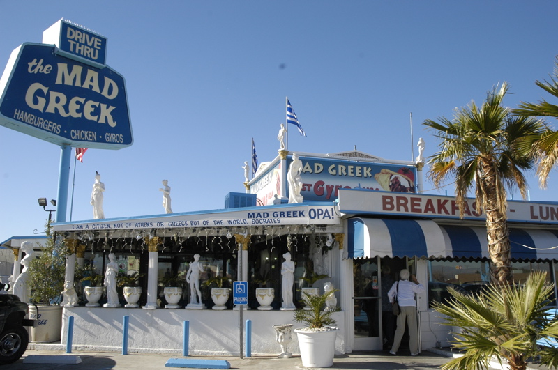
He’s big, he’s bad, he’s … oh wait, he’s a myth. It says so inside the restaurant. There’s no such thing as a mad Greek, according to signs, which also bust other “Greek myths” and list dozens of influential Greeks. There’s some serious Greek pride here, and I don’t mean the fraternity type.
Right along I-15 in the desert town of Baker CA, you’ll find The Mad Greek, home of the “best gyros”. This place combines the indoor atmosphere of the Madonna Inn with the food of a Tarpon Springs (FL) restaurant. Kind of fun, and they make a “fresh strawberry” milkshake that is justifiably boasted about on billboards up and down I-15. We made it our lunch stop on the way to the Las Vegas area.
After a beautiful drive through the wide open country, we are now parked in the driveway of our friends Brian and Leigh, who were famous in the Airstream community for their full-time blog called 63flyingcloud.com. (The blog has since been continued by the new owners of that Airstream.) Being former Airstream travelers, our hosts know exactly what we like, and so we have water, electricity, wi-fi, access to the house, and an offer of dinner tomorrow night. We’ll spend two nights and figure out what we should be doing next.
December 3, 2007 at 9:11 pm · Filed under Roadtrips
This time of year, even in the southwest, our major challenge is nighttime cold and early sunset. The short days mean that we need to plan carefully to get our driving done by 5 p.m., and at night the temperature in the desert plummets abruptly and requires us to use the furnace.
Still, I like to boondock in the desert when we get the chance, and today is one of those chances. To be ready, we need all the systems topped off. Out in some of the lonelier spots in the desert, even in some camping areas, you can’t count on any support or services.
So today we filled the fresh water tank and dumped the holding tanks before leaving the campground, our usual procedure. We always travel with full fresh water because — even if we are planning to go to a place with hookups — plans change. This policy has saved our day many times. Then we stopped off for a big grocery shopping expedition near Santa Clarita, and filled both propane tanks. At California prices, 14.5 gallons of propane (we were nearly empty) cost $54.50, the biggest single propane bill we’ve ever had.
Living in the Airstream certainly makes us well aware of what we consume on a daily basis. We took on 30 gallons of fresh water, 14.5 gallons of propane, 20 gallons of gasoline, and nine bags of groceries. We also dropped off one grocery bag of trash, about 20 gallons of gray water (four “Hollywood” showers and some dishes), and about 5 gallons of black water. I’d topped off all the tire pressures in Riverside a week ago, so we didn’t require any compressed air, and our batteries were already full courtesy of the sun.
The goal for tonight was simply to end up somewhere between Ventura and Las Vegas for a night, but what I really wanted was a quiet spot in the desert where we could see the stars. We skirted the north side of the Los Angeles metroplex from Santa Paula to Santa Clarita, then to Victorville and northeast on I-15. This avoided the worse of traffic, but still we found ourselves in a minor traffic jam near Santa Clarita.
Normally I don’t drive in the HOV (High Occupancy Vehicle) lane because we generally try to avoid places where HOV lanes are necessary. Also, in California all towing vehicles are limited to 55 MPH, which is a speed no self-respecting California will drive in a car if they don’t have to. So driving in the HOV lane with a trailer is a quick way to make enemies on the road.
But this time I made an exception because the HOV lane was the only one moving and legally we qualify with three people in the vehicle. While breezing down the road I reflected that we drive an SUV, and with the trailer we are an SUV-RV combination, and now we were an HOV-SUV-RV. But only for a few minutes.
[Edit: Don’t do this. Apparently towing in the left lane is illegal in California, which I discovered only later from a blog reader’s comment.]
Next morning at Stoddard Valley OHV Area
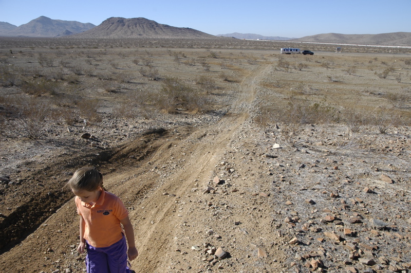
Along I-15 south of Barstow is the Stoddard Valley Off-Highway-Vehicle (OHV) Area, and after dark it seemed an ideal spot to stop for the night. Two exits lead to large dirt parking lots and a maze of roads through desert sage and cactus. We’re parked in one of the dirt lots, which I think makes us into an OHV too.
There are absolutely no services here, no lights, no rangers, nothing. Just a quiet spot within view of I-15 but far enough back that we can’t hear the highway inside the trailer. According to the web site campers can stay up to 14 days. There’s nobody here other than us tonight, probably because it is Monday and the temperature dropped into the 40s after sunset. That’s fine with us. It should be a pleasant night here, in our OHV-SUV-RV.
November 7, 2007 at 7:57 pm · Filed under Roadtrips
We are in Yosemite at last, and it’s great. The weather is beautiful (upper 60s, sunny, and dry, low 30s at night), the pines are tall, and the granite of the sheer cliffs is glowing brightly in the sun. Best of all, there’s hardly anyone here by Yosemite standards.
Getting here was a bit of a challenge. Route 49 is highly scenic and dotted with cute western downtowns, but a tiring road to pull a long trailer on. Those who are averse to sharp turns and rolling terrain should, as they say, “seek alternate routes.”
It got even more interesting when we turned onto Route 120 into Yosemite. The Old Priest Grade has been replaced by a shallower but much more twisty route for several miles. The hairpin turns overlooking a steep drop where you’d most want to see a guardrail seem to rely on Darwinism rather than protectionism, e.g., if you drive too fast (over 25 MPH or so) you will leave the gene pool permanently. We kept the truck in low gear and took our time.
Good thing the brakes are working again, too. Coming into Yosemite Valley via Rt 120 means a lot of descending. We paused about 3/4 of the way down and I could smell the brakes. Overall, I’d rather take Rt 140 but it is still closed to vehicles over 28 feet long (total length) due to a rockslide and CalTrans says it will be a looooong time before that changes. On the way out of the park, we’ll take Rt 41 to Fresno. It features a hefty climb out of the village, but it is the only viable route to the south, and that’s where we are headed next.
 On the way in we stopped for lunch along a lake just outside the park. It’s a beautiful area to visit anywhere around here. Hard to go wrong. That’s the flip side of the hairy roads. I wanted to get into the park by 2 pm but the scenery and twisting roads made us slow down to the point that we arrived sometime after three.
We have once again linked up with the McDills, and the girls are constantly off in the woods that surround all the campsites, playing adventure games. We had to establish boundaries so that they wouldn’t disappear on us. Robert is indulging his fetish for campfires (which is fine with me) and since there is absolutely no chance of gaining solar power in here due to the Ponderosa pines everywhere, the McDills are also graciously allowing us to plug into their Yamaha 3000 generator in the evening. That helps, since overnight temperatures are dipping into the 30s each night and we are using the furnace quite a lot.
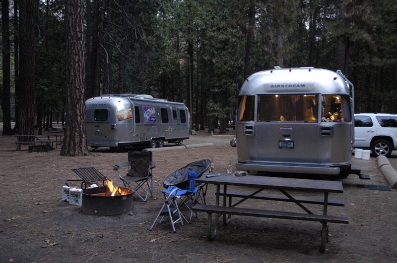
The photo above of Upper Pines campground shows the typical conditions in the early afternoon. Although the sun is shining brightly above, in the forest it is fairly dark all the time. It reminds me a little of our very dark and damp stay in the redwood forest last summer.
Internet is only available at the Ahwanee Hotel, so Kelli and I are making a daily pilgrimage there to get our email and post our respective blogs. Verizon does have limited cell service in the center of the village but it is “extended network” and as is commonly the case, that means my Verizon data card won’t work. Verizon claims it will work everywhere I can make a voice call on my Verizon phone, but it just is not true. I look forward to the day they finally get it all together.
October 26, 2007 at 9:39 pm · Filed under Places to go, Roadtrips
Things are turning around. The makers of our disc brake actuator, Active Technologies, came through promptly with some good news this morning. They have a few refurbished units which match ours, and put one in a box destined for delivery to us on Monday. This is better than getting the newer unit because it will be a direct-fit replacement and thus won’t mystify the local RV repair shop quite as much.
With this happy news, we embarked fifty miles south to Tillamook. Our friend Gunny has been parked in Salem in his Airstream 25FB, patiently waiting for us to show up and visit. I was worried we’d be forced to skip past Salem by the ripples from this delay, so we invited him to meet us at the Tillamook Dairy.
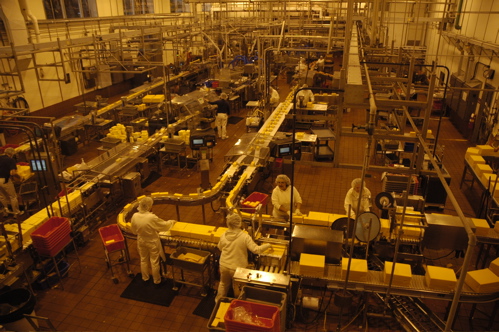
 The dairy is the major attraction of Tillamook. Even now, in the off-season, the parking lot is busy with hundreds of vehicles coming and going all day. The Dairy is a cheese factory, with a casual restaurant and a couple of ice cream bars inside too. You can take a self-guided tour overlooking the production lines, which is fun for people from 7 to 60-something years of age, as we proved today.
There are a couple of other tours along this stretch of Rt 101, according to Factory Tours USA. These include Pacific Oyster, just a couple of miles north of Tillamook, and The Real Oregon Gift Myrtlewood Company a bit further north. We dropped in on Pacific Oyster but there’s only an oyster shucking operation to see and the line was closed when we arrived.
Route 101 is the real star of this trip. The road rolls and sways, dipping into cedar forest and then rising far above the ocean to reveal stunning views. It’s like this all the way from here to Humboldt County in northern California.
Seaside Oregon is another little gem along this route. This town looks like just a strip mall from Route 101, but if you head west across the river at Avenue G, you’ll find the Lewis and Clark Salt Works location neatly enshrined among a neighborhood of cute little shingled cottages. Park here and walk to the water. Seaside has a large flat beach insulated from the neighborhood by a deep barrier of sea oats, and it’s really beautiful. In the early evening we found dozens of people crabbing in the low tide zone while the orange sun set cast reflections on the skim of water that still covered the sand.
Now it is starting to feel like there won’t be time to visit all the things we want to see in this area. That’s perfect. I’d much rather feel I left a spot a little too early, than feeling like I stayed too long.
October 15, 2007 at 6:23 pm · Filed under Roadtrips
As expected, some weather will be coming in on Tuesday. After weighing the options, we decided to head out of Banff National Park today rather than depart on Tuesday and risk icy roads. We had considered driving about 80 miles up the Icefields Parkway to see the glaciers, but in the end it seemed best to enjoy a sunny day’s drive out of the park. We’ve gotten a taste of Banff, and now we know what we’ll want to do on the next visit (and when!)

The drive out was as gorgeous as expected. Heading west from Lake Louise the road passes through Yoho National Park, then Mt Revelstoke, and finally Glacier National Park. It winds through razor-sharp ridges carved by long-ago glaciers, along lakes, and following the transcontinental Canadian Pacific railway. Up above, several glaciers can be spotted, slowly sliding their way down the mountains (typically a few feet each year).
As we drove we spotted some very nice log cabins, probably vacation homes, and this kicked off a discussion that Eleanor and I have had a few times before. It goes like this: “Gee, isn’t that a nice cabin?” “Wouldn’t it be nice to have one?” “A nice weekend getaway!” “But where?”
And then we realize that although a getaway cabin sounds nice, and they look nice, we would already have one, with wheels. We like the idea of the log cabin but in less than a year we’d certainly be bored with it. We’d be thinking of all the places we’d like to go explore other than the same acreage around the cabin, and I’d get tired of the maintenance and expense “¦ and soon we’d be “getting away” from the cabin, too.
For a leisure vehicle, the Airstream is extraordinarily practical. It is much cheaper than a vacation home, requires less maintenance, and goes almost anywhere. I like the idea of living on a boat for a while, for example, but it would be much more limiting than the Airstream. I like the idea of a cabin in the woods, but it’s too much trouble. I like to stay in nice hotels once in a while, but they are vastly more expensive. That’s the problem with the Airstream. It’s just so practical that it makes the alternatives look like outrageous luxuries or financial traps.
Tonight the vacation cabin on wheels is parked in a less-than-exciting spot, a Wal-Mart in Kamloops BC. A light rain started almost the minute we pulled in, but since it’s much warmer (59 F) here at lower altitude there’s little worry about icing tomorrow. We are now on Pacific Time and will probably stay in this zone for at least several weeks as we meander down the west coast. Our short-term goal is Vancouver. If I can find good online access and a nice campground for a few days, we’ll stay and explore the city before crossing back into the US. Otherwise, we’ll cross back into the US and begin our travels in Washington state.
October 12, 2007 at 3:52 pm · Filed under Roadtrips
[Note: this blog comes to you via a wifi spot near Lake Louise. Since I have to post this sitting on a bench outdoors, I’m skipping the photos until later. I’ll update this blog with all the pics when I can.]
Before I launch into this blog I should share some background. Eleanor has been talking about visiting Banff for over a decade. It has become, as the result of years of fantasizing about it and seeing photos, an almost mythical destination for her. Being the wonderful husband I am (even though I’m not willing to spring for a night in the hotel as Danine suggested) I promised to get her here.
This helps explain why coming up here is worth the trouble and expense. And believe me, there’s plenty of both involved, especially this time of year. We’ve been routing ourselves since late August specifically to get to this particular spot. Every decision, every stop, and our entire schedule has been oriented toward getting to Banff before the snow made it impossible.
This morning we packed up, said goodbye to Bert and Janie, and began the 300-mile trek north on Rt 93. The trip took over seven hours because it’s almost all “blue highway” and of course we made a lot of stops: dropping off mail in Whitefish, MT, a final US gas stop at Eureka, MT ($2.91 per gallon), crossing the border, and of course the innumerable bathroom stops.
Border crossing is becoming a little more structured these days. We’ve gone into Canada dozens of times, with and without the Airstream, and in the past couple of years it seems that the friendly Canadian officials are becoming more like their US counterparts. They are asking more questions, checking things a bit more often, and taking more time. The crossing still took less than five minutes but I was interested in the fact that the agent asked me twice about weapons and was careful to verify our identities (even to the point of taking a peek at Emma and comparing her to her passport). While passports are technically not required for land travel across the US/Canadian border at this point, it won’t be long before they are.
Route 93 follows the western edge of the Rocky Mountains in British Columbia, so that there’s almost always a view of steep and craggy peaks to the right (heading north). They were green down low with pine and bluish above, lightly frosted with snow. Occasionally we’d see a bright yellow squiggly line winding down the sides of the mountains, caused by the fall foliage of the aspen trees. They follow the avalanche routes, because they grow more quickly than the pines following the scouring of a massive snow slide.
The other color delight is the delicious blue/green water that is found in nearly all the rivers and lakes. It’s a translucent Caribbean blue, but more amazing by being surrounded by sharp granite and pine trees. We don’t yet know why the water here is that color, but I will try to find out.
We picked this day to travel because the weather forecast showed a stretch of good weather for the next four days. This time of year, a snowstorm could make us semi-permanent residents. All of our escape routes involve high mountain passes where tire chains are required for vehicles towing trailers. We don’t have chains and even if we did I don’t want to tow the Airstream on roads that would require chains. So we’re counting on sunshine and will be checking the weather daily for reports of a storm over British Columbia or the Pacific that might suddenly drive us out.
Even today, a fairly decent day with a slight overcast, gave us a hint of how quickly things can change. From Route 93 at Radium Springs, we turned right into the Kootenay National Park and the road began to climb steeply into the mountains. At times the grade reached 10% (with a speed limit of 70 kph, about 35 MPH) and within a few minutes of this the clouds were thick and ominous, with occasional rain spitting down and temperatures falling rapidly into the low 40s.
Things began to go a bit off after we entered Kootenay. The corner gas station in Radium Springs, at the entrance to the park, showed a price of CDN$1.15 per liter (about $4.34 per gallon). Knowing that fuel along Rt 93 had been in the range of $1.02 per liter ($3.81 per gallon), I decided to skip buying gas there. We had 3/8 of tank according to the gauge.
In retrospect, I should have bought 3-4 gallons at the outrageous Radium Springs price just to fatten our fuel margin. Although we had plenty of fuel to travel the remaining 80 miles to Banff under normal highway conditions, I forgot to calculate in a safety margin for the extended climbing we were about to do, and the lower efficiency of the gas engine at high altitude. I also shouldn’t have trusted the fuel gauge, because it is not entirely accurate.
Then things began to go further awry. The campgrounds in all of Kootenay National Park were closed for the season. This mandated that we drive all the way to Banff, leaving no alternative to stop for the night. Occasional rain began to fall. The very early sunset of this northern latitude began to occur at 6:30, made worse by the heavy clouds. The peaks that surrounded us were now largely obscured by clouds. And the fuel gauge started to fall rapidly.
I did a quick calculation when the yellow “low fuel” light went on. We’d traveled 207 miles since the last fillup. If we got 8 MPG (our absolute worst-case fuel economy, reserved for days when we tow against 20-knot headwinds), we’d run out at 224 miles, about 10 miles short of the next fuel station in Banff. If we got 9 MPG, we’d have about two gallons to spare. I don’t like shaving it that close. I was envisioning myself pedaling along the highway breakdown lane in the dark for ten miles, with rain hitting my face, and then hunting down a fuel can and begging a ride back “¦
Fortunately we did make it to Banff without a problem, and when I calculated our economy I found we averaged 9.1 MPG for the route. The tank took 25.4 gallons at $1.00 per liter, for a record-setting fillup of CDN$96. (Canadian and US dollars are only two cents apart now, so figuring the US-Canadian conversion doesn’t make much difference.) It will cost us at least $200 in gas for our trip to Banff, counting side trips, but Eleanor is worth it. She reads this blog, you know.
September 20, 2007 at 9:00 pm · Filed under Roadtrips
 This morning in Guernsey State Park we woke up to find fog covering the lake and our campsite. I opened the Airstream’s door and discovered a wonderful smell, reminiscent of cinnamon toast, like a light perfume. It seemed to be coming from the yellow flowers that are everywhere, but it was so faint that only when the air became still overnight did it concentrate enough to be detected. We all piled out in our pajamas to explore, and Emma led Eleanor back down to the dry lakebed to hunt for more rocks. A few minutes later, the fog began to lift and a light breeze resumed over the lake.
Emma’s searching of the lakebed last night turned up several nice pieces of jasper and agate. A few are keepers, including one we’ve never seen before: a light yellow-brown jasper with tiny black spots in it. Our Airstream is getting heavier by the day since she became a rockhound.
Since we are back in the west, we are camping without hookups more often and once again relying on the solar panels to keep up our batteries’ charge. Back east, the solar is not very useful since electric is often available, and clouds and overhanging trees limit our ability to recharge. I’ve discovered that light to moderate fog like we had this morning is not a serious detriment to recharging. In fact fog seems to increase our power-gathering ability in the early morning by scattering the light more evenly to the panels. Our panels don’t tilt to take best advantage of the sun, so in the early morning and late afternoon our power generation capacity is greatly reduced. A little fog can be nice.
 During the middle of the day this time of year we usually get enough sun to fully replace our usage from the night before, and yesterday was no exception. But once the temperatures start to drop and nights get longer, we’ll be much more challenged to stay afloat without plugging in once in a while. If we get to Yellowstone in the next week, as we hope to, we’ll have a real test of the system.
To the left is a photo of the entrance door of the Guernsey State Park Museum. It’s a real gem of Civilian Conservation Corps construction from the 1930s, all handsomely fitted Wyoming stone with cypress doors from Florida and quarried flagstone floors. I was more fascinated with the building than with its contents. The arrow on the floor points west to Laramie Peak, clearly visible on a clear day.
I completely forgot to mention that we have left the Honda Fit behind in Denver. It is safely tucked into a private garage under the care of a good friend. We will miss it. It was incredibly convenient to have it as a runabout, and a real gas-saver too. But this is our closest point to Tucson for at least two months, and it would be thousands of miles extra on the car to bring it along our planned route. From here on, we will resume traveling with just one vehicle. Once we arrive at home base in Tucson, sometime this winter, I will fly up to Denver and fetch it.
I also forgot to mention that our household goods arrived safely in Tucson and so I can now publicly vouch for the company that handled our move, Broadway Express. Broadway Express and ABF were both recommended to me by blog readers as less-expensive alternative to full-service movers. “You pack it,” is their deal. You also load the truck yourself, or hire your own laborers to do it. Doing the work ourselves (and hiring someone to unload the truck at the destination), we saved about $2000, well worth it. Of course, it helped even more to move as little stuff as possible, which we did thanks to two summers of energetic divesting.
Since we’ve gotten out west, we have had plenty of suggestions of places to go, from blog readers. I really appreciate all those tips, even though we can’t take advantage of most of them. If you’ve got a suggestion, put it on the blog as a comment (click the link at the bottom of the post) so other people can benefit from it too!
Today we decided to get up to Thermopolis to spend a few days checking out the mineral hot springs. The drive from Casper to Shoshoni is long and fairly bland for about 70 miles, with virtually no services along the way. The road rivals US 50 in Nevada as one of the loneliest we have driven. We topped off in Casper before starting that leg.
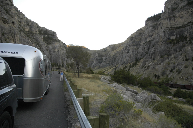
Once past Shoshoni the road turns north through the Wind River Canyon, a really neat drive. Through the winding and deep canyon is the highway, the river, a few campsites, and the railroad. Three short tunnels added a little excitement to the road for Emma. Along the way, signs point out the rock formations, which are a real geology lesson, going from the Cambrian era (500 million years ago) through the Triassic (a little over 200 million years ago).
We are camped at a campground that boasts the world’s third-largest hot water pool. We can smell the sulphur occasionally at our campsite. And where’s hot spring #1? In town, of course, at Hot Springs State Park, just a couple of miles away. We shall “take the waters” as they say, tomorrow.
« Previous entries ·
Next entries »
